Friday, August 30, 2013

Um, it looks like a Stellar Weekend here in Santa Cruz.

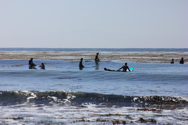
If today is any indication of what is to come, then it is game on folks.  Come to town if you are not already here.  With the north Sierra still getting smoke, and SoCal getting than monsoon thing going, and the valley if for sure getting hot, why would you want to be any place else.  I should have stuck with my gut.  Yeah, sure, fog creeped in Thursday morning, but today the entire town was sunny at daybreak.  A new south swell was on the point, and along the cliffs, the breach weather was perfect.  I might have even received a bit too much sun on my shoulders.  Superb.  And that is what we have lined up for the next few days folks.  It was 76F when we pulled out of the beach parking lot at noon today.  Much hotter than that right now out on my deck.


Empty waves within view of the Bush Compound.  Wells Beach, Maine.


Sunny mornings through Labor Day, as a decent looking storm moves through the Gulf of Alaska first pushes brisk north west winds over our outer waters, blowing out the fog.  Then break down the pressure gradient, and maybe even giving us the first real off shore flow of the season on Monday.  Look for it.  Light sea breeze should pick up by the afternoon.  Then we will likely return to foggy mornings.  Expect mid 70s here in town through the holiday, maybe a touch cooler after that.  Labor Day itself looks like a nice one if you plan to head to more wind exposed areas, like Natural Bridges or one of the many beautiful beaches just north of town.

I still see a slight chance for some showers on Monday.  But it is hard to really look at that, when at the same time a solid storm is forecast to develop along the Aleutian chain.  Now recall, a week or so back, that the current small system in the Gulf was model quite a bit stronger.  But, it kind of looks like fall out there right now.  This current storm will send us waves, and likely a spell of nice weather.  And it could even bring rain.  Think about that as we finish off August.

In short, it is going to be some great weather in Santa Cruz.  Some wind in the afternoons, but if you can get yourself out of the breeze, it will be warm.  Lighter winds on Monday.  Maybe fog returns on Tuesday.  More as we get closer.

Wednesday, August 28, 2013

Good Weather, Bad Fire.

You've heard about the fires, right?  The American, and now Rim, blowing smoke up in the Sierra.  Met a guy and his daughter on the beach today from South Lake.  They decided to come down here for their days off, and enjoy some crisp, clean air.  Strong southerly flow along the west slope is the culprit up there.  Those winds should settle a bit by this weekend, but they don't switch direction.  If you are headed any where north of Yosemite, check conditions before you go.  These things will likely burn until the first precipitation of the upcoming wet season.  I'll try to report back here before the coming weekend in regard to the expected conditions.  I have plans to be south of Tahoe, and it sounds like right now, that is not the place to be.  May need to stay at my lovely home for the long weekend. What to expect?


Mini perfection.  Riderless waves are all over the Maine coast.  Spirals, Wells Beach.

Surprisingly nice out the last few days.  The fog never really returned on the west side, so we enjoyed the sunrise three days in a row.  I can confirm that today the fog lingered on the east side well past 10am, and that on Sunday by that time it was super clear and nearly hot.  All in all some nice weather with a bit more warmth to it than last week's.  Mid 70s the past few days and warming up still.  I would bet it will hit 80F downtown on Friday.  That's the peak of it though.  Staying in the mid 70s through Labor Day, and beyond.  The forecast is for patchy fog in the mornings.  I'm betting that looks like the past few days and am hoping for early sun here and up north.

As for that possible rain thing.  Delete that.  Current theory has storm pick up moisture, wind itself up, and die out before drifting ashore well north of here.  Current theory also has a more significant looking system dipping into the northern Gulf of Alaska around that same time.  Hey folks, the ocean has been pretty calm for a few weeks now with mainly small to tiny surf.  We will see some wind swell before Friday from the slow pressure that has been up there for a few days.  It even looks like it is still producing, so waves could last through the weekend.  Not a surfer?  Sure.  But if you've been playing at the beach with little ones, or walking around some rocks, just remember that as we move into the fall, the ocean intensity increases.  These north west swells can arrive with a fury.  The ones coming at this week's end aren't much.  Just more than what we have been getting.

More on the smoke, fire, surf and fog in a few days.

7PM EDIT:  I take that back about the fog.  Looks like it is creeping into even the west side tonight.

Monday, August 26, 2013

More Summer, but a Very Slight Chance of Light Rain for Labor Day.

If you are planning on having a BBQ, you might want to listen up.  Something to monitor is is the charts.  But first, can we please talk about how awesome Sunday was.  The marine layer failed to fill in to the coast, but rather lingered just a bit off shore, allowing sunshine and building warmth form the early morning hours to undisturbed by strong on shore winds.  The result was a simply fantastic day.  Kind of epic for late August, and really a taste of what we should be starting to see as the norm over the next month.  Anyway, the forecast.  Fog filled in last night.  Grey mornings for this coming week with lows down around 57F.  Actually, kind of warm.  Afternoons begin just around 70F today, but will be pushing into the mid and upper 70s as the week progresses.  This thanks to a weakening wind gradient on the off shore waters and less of a breeze to cool things off.  So, in other words a taste of fall.  And with a little luck we could see that marine player pull out a bit due to the weak low pressure building in the Gulf.

Shore pound at Wells Beach, Maine.  How I miss that sultry New England summer air.


Speaking of that low pressure, it might just send us something of interest to start off next week.  Broad and relatively weak low pressure fills in the Gulf early this week and slowly comes down the coast, pushing rain along the BC coast.  Vancouver could see rain all week totaling upwards of three inches.  Moderate rain extends down to Oregon.  This little system could wind up a smaller one and send it at the California coast near Humboldt.  A trailer from this second system could come through our forecast area late Sunday into Monday.  Slight chance for rain from Monterey north, with a greater likelihood from Marin north.  Check back here for updates.  For sure something to monitor as the NPAC continues to remain active.  Fall is near.

Tuesday, August 20, 2013

Slow return to the same ole Summer.

Now that was fun.  If you don't really watch the weather that closely, you may have not have noticed the oddity over the past few days.  This morning's rain could easily be mistaken for just some heavy fog.  Or the storm clouds streaming in over the bay on Saturday could go unnoticed.  Even that chill in the air could feel just left over from a chilly morning.  But that was a touch of fall folks.  We return to our normal programming later in the week.  As the threat for showers focuses more on the northern part of the state, we have a clear sky this afternoon.  The only thing keeping tomorrow from being regular is the light south west flow we have going right now.  But even that is not all that atypical.  Low pressure is swiftly moving ashore to our north, and for at least a few days, the summer time high is setting back up.


Surf casting on a grey morning at the Oginquit River mouth.  

Foggy mornings and clear afternoons are on tap.  Upper 60s on Wednesday, with light winds through the day.  Gonna climb up into the lower 70s to finish out the week, with northwest breezes building through the afternoons.  Weak and broad low pressures again noses into the Gulf of Alaska this coming weekend, likely suppressing local winds.  I should mention that small short and mid period wind swell is hitting the north coast right now giving us a pretty fun dose of chest high waves.  Find the right spot and have a good time.  That should dip in size a bit as the week progresses, but wave heights should be up over the weekend with more NW wind swell filling in.  We may even see some steep angled south.  With the light winds in play, it sure is glassy out there.

Long term things are still looking like we are in mid September.  We are even seeing extra tropical energy rebounding back east through the Pacific forecast for this coming week.  Low pressure continues to toy with the Gulf.  The mega storm building on the 27th has been down sized to something more reasonable, but it is still on the charts.  Energy is moving.  We are moving.  While summer is returning by Thursday, with some luck it will be gone soon.  Bring on warmth and sunshine.

Saturday, August 17, 2013

Interesting Mid August Forecast - Includes Actual Weather!

How is this for a mid August day by day?  I'll tell you what.  It lacks the usual foggy morning, clear, breezy afternoon monologue.  High clouds persist today in Monterey Bay.  The typical morning fog cleared around 10:30 this morning, but winds have not come up hard, and high streaming clouds are drifting into the bay from the west south west.  Gonna maybe hit the mid 70's today.  As weak high pressure gets further suppressed by a small winter like system in the Gulf of Alaska, cooler air will move in.  Sunday morning looks to start in a similar fashion, but only warming to about 70F.  After that, things really start to get fun.  That small winter like system I mentioned will energize the typical south west low pressure, an draw it north, over our region.  Yup, "energize" does mean rain.

Wells Beach, Maine.  High tide, hot, humid, touch of swell in the water and off shores.  Different July than here.


As we move into Monday and Tuesday, we start to see increasing chances of showers and even thunderstorms.  Greatest chance at higher elevations, but pockets of showery popcorn clouds could pop up.  Yes, we may actually get a little rain early next week.  It is not super likely here for us just yet.  Or rather, actually forecasting how a system like this will behave is not easy this far out.  So keep an eye out.  But, in short, it looks like upper 60s through Wednesday.  Decent chance for some pockets of morning fog along the coast, but the low pressure that takes over should keep the marine layer at bay.  Although, it will have its own clouds, so even afternoons will remain partly to mostly cloudy.  Wednesday will see clearing, and maybe a return to more normal fog weather.

This is all interesting and all, but what is really interesting is how the long term GFS keeps on generating more and more progressive forecasts.   It has a warm high pressure day developing after the coming weather, and a nice warm clear day for next Wednesday, with good looking fall like weather behind it.  It has a decent swell producer moving into the Gulf of the Alaska from about the 27th until the end of the month.  It had what looks like extra tropical energy behind that turning tight powerful storm marching across the north Pacific to start the next month.  It even has serious rain makers hitting Seattle around the same time.  I'm gonna keep looking at this.  This is what we expect late next month.  If you are like me, and find autumn to be your favorite season on the Central Coast, it is hard to not get a little excited for the coming month.  But don't hold your breath.  These are all just long term fantasies of the model.

Thursday, August 15, 2013

Is that a Taste of Fall in the Air?

When I walked out onto the deck last night to pull in my shoes I was startled by the clear sky and twinkling stars above.  Maybe the song I use to put my son to bed had some good luck in it.  Then, this morning, I heard my wife gasp as she prepared for work.  "Sunshine."  We enjoyed our first sunrise since our return home at the beginning of the month.  I knew it was bound to be a killer day.  Low to mid 80s out there right now, and select spots feel a bit warmer.  Not too much of sea breeze in town.  Windy up the coast for sure, though.  So, not quite like autumn.  autumn is nicer.  But close enough.  Not sure it will last though.  Let's take a look.

Even the cloudy mornings in Maine were warm and sunny.  Ogunquit river mouth.  


Low pressure is currently trying to get a foot hold in the Gulf of Alaska.  This is number two since the north Pacific awake from its summer slumber last week.  Not much of a swell maker this one, but current models get some wind traction on the water over the next two days, so some small swell might result for the coming weekend.  More importantly, this thing could help keep the pressure gradient at bay, and give us a bit of sunshine this late week, as the marine layer has pretty much pulled out to the coast.  Except in Santa Cruz county, where it has pulled out to sea,  Good for us.  Again, not sure if it will last.  NOAA is calling for foggy mornings the next seven days.  I think we might get one more sunny morning, but I too am not counting on it.   Still, my money is on an early burner off, so I'll callit another winner.  Sunny, with a high of 82F downtown, and 75F at the Boardwalk.  Foggy mornings return with the weekend, and daily highs drop back down into the mid 70s.  Might even drop into the upper 60s the early part of next week.  Depends on how thick the fog grows.

The mid and long term models keep low pressure systems moving into the Gulf.  Nothing impressive on the charts, except for the fact that it looks like the dominant high is not rebounding quickly, which can suggest a shift in the seasons.  Seems a bit early for this, though.  Usually this is what I look for come mid September.  But, it does peak my interest, and I would not mind moving away from the grey, windy weather we have been having.  Fall, and fall surf, can never come to early in my opinion.  Stay tuned.

Sunday, August 11, 2013

To Be Continued: Fog.

I guess three weeks in the east was not enough to avoid summer all together.  This morning feels particularly glum as I pack my wife and son into the car to head to a pool party in Concord.  Where is actually feels like a real summer.  And depending on your outlook, it sure feels like a Santa Cruz summer down here in Santa Cruz.  So, not much to report today.  Morning fog brings damp, cool, grey weather.  Clearing around noon time, as the north west breeze picks up.  Afternoon high of about 70F.  Warmer in the Banana Belt and inland zones, cooler at the water's edge.  Fog fills in just after sunset.  Overnight lows dropping to about 53F.  Typical summer.

No matter what the weather, tide pools are always fun.  The Hook, Santa Cruz.


If I see much of interest, I'll post up here.  In the meantime, the surf is going flat and no swell is on the way.  The north pacific does show some signs of waking up, so I will continue to monitor.  In the meantime, I'm oiling my bike chain and getting ready to hit the trails for a few weeks.  More to come.

Tuesday, August 6, 2013

Fog and Drizzle Short Term. Basically, more of the same Long Term.

This time of year you can pretty much tune out and have a pretty good guess on what the weather will be like.  Kind of like the run we have right now.  Overnight, clouds move in from the ocean.  Fog thickens and the overnight low is hovering a bit above 50F.  Morning breaks thick, damp and cool.  A bit of blue sky pokes through up by the hills around 10AM.  A breeze kicks up off the ocean and it is predominately sunny by just after noon.  Temps peak out a hair above 70F.  A touch cooler along the water's edge.  Check back in in late September when summer is finally over and things begin to get a bit more interesting.  Or you can pay attention so that you are not stuck inside doing some mundane project when the good days show up.  Not that we really have any of those on the radar.  The details...

Foggy mornings and small waves.  Must be summer time.  The Hook, Santa Cruz.


The next few days look especially grey in the mornings.  Drizzle is to be expected.  Not really the best weather for tomatoes, although ours are still looking quite healthy.  The afternoon sun is helping.  We should see the sun on Wednesday, but some spots that really trap the moisture could stay patchy throughout the day.  Dreary, yes.  More of the same through Friday.  Still a bit of a chance of some eddy wind flow which does not help in promoting sunshine.  By Saturday we see more of a robust high pressure returning, and along with that north west flow and sunnier days.  Expect the burn off earlier in the morning over the weekend.  Or let us at least hope that is what happens.  The good news wrapped up in all of this is that the afternoon highs and overnight lows should be climbing a bit over the week.  Today's 51/71 is next week's 54/74.  Wow.

What is interesting to me, if the feature may be keeping the winds at bay the next few days.  A small, tight low pressure system wound up the past few days just south east of the Aleutians.  By winter standards, this storm would be pretty small and insignificant.  But being that we are smack dab in the middle of summer, this thing is awesome.  For the surfers, we should see a small mid period swell coming from the northwest sometime late Friday and into the weekend.  Might need to take a trip up to OB if the morning winds would cooperate.  The remains of the storm winds down in the Gulf the next few days, suppressing the high pressure a bit.  More low pressure is forecast to move into the Gulf next week, although this system in much weaker and much broader.  Of weather interest for sure.  We will have to watch how all this plays out.  The fantasy models have rain hitting the west coast in two weeks from Canada all the way down into Mendocino County.


Friday, August 2, 2013

Well, I'm back, and ready to post up some forecast.

It was a fantastic three weeks of exciting weather in the north east.  Hot and humid days breaking well into the 100s, summery rain storms dumping buckets,  and a few perfect beach days thrown in for good measure.  Not 100 percent sure, as my phone, which is my main connection to weather models while I'm on the road, took a swim early on, but it was pretty un-eventful back here.  Day time highs in the upper 60s and low 70s, with foggy mornings, and some afternoon clearing.  Kind of what we have going on right now and for the next few days.  Here is what I see.

Sunny summer mornings are going to be rare this coming week.


Fog in the morning tomorrow, clearing around noon here in town.  A little less breezy on the water than it was today.  But not much.  70F downtown, upper 60s along the water.  Saturday we could develop a south flow and remain foggy late into the afternoon.  That would keep it a touch cooler.  Sunday should see a return to NW breezes and a clear afternoon.  Might see a return to south flow, say on Tuesday.  Kind of a run of not awesome, but not horrible weather.  Mind those tomatoes.  If you see the mildew getting to them, pull them for your neighbors sack.  Don't take down the entire blocks crop.  Mine look pretty healthy right now, so I can't complain.  And if you surf, get it before it is gone.  South swell continues through the weekend, but things look pretty small for next week.