Just a short update this evening. It is cold in the mountains. It is cold in town. The storms are trending toward the west and most rain is expected to fall off shore. The GFS is calling for a few tenths of an inch through Tuesday. The Canadian model is much wetter, but still just barely reaching a half inch. NWS has cut back on their forecast as well. Expect wet weather over the weekend, but don't let that stop you. It will be light and maybe nothing at all. In other news the hopes I had for 70F seem squashed. This high pressure is going to provide some warming, but mid 60s is really the best we can hope for.
I'm going to keep it short and go stoke that fire. It was 0F outside this cabin when I woke up at 7AM. We saw ice crystals vaporizing when the sun hit and it was actual cold smoke. So cool. Or cold.
Friday, February 24, 2017
Thursday, February 23, 2017
Showers and Ballon.
Cool weather continues over the next few days. Mornings are especially crisp, with lows in the mid to upper 30s. If you are a bit inland, and low, and shadowed, it could be cooler than that. Tie Gulch would be an example. They dropped to 29.8F this morning. The day should be otherwise pleasant on Friday with plenty of sunshine. The winds will pick up to a moderate speed from the south tomorrow, ahead of an approaching storm. This one does not look like it will hit us directly, but we could see wrap around moisture filling in during the afternoon on Saturday. It won't be much. Perhaps a few tenths of an inch by mid morning on Sunday. Whatever doe come, it should wrap up by late in the day Sunday. This thing is is a cut off low, so we could see it miss us completely, or hit us more directly. Sunday night a second round might swing through, but this one currently looks even lighter. It could have lasting showers for the Monday morning commute. Normally, this would not be much of a concern, but with our water loaded earth, something to consider. About a half inch total from Saturday through Monday. The cool thing is snow levels will be low. Below 3000 feet at times. So we could be enjoying some snow on the mountains around the bay again next week.
Here is the awesome news. By Tuesday, the storms clear out and high pressure begins to set up on Central California. A nice fat bubble of high pressure. The week will begin on the cooler side, but we could see some real warming with that early March sun. We will be back in the 60s by Wednesday and shooting up to the mid and upper 60s by late in the work week. And get this. It may stick around through mid month. Yes, we actually may see not one, but two weeks of sun. A chance to dry out. That would be awesome.
I'm up in the Sierra right now. There is so much snow. A tremendous amount. Drought is only recorded in less than 17% of the state. Only 4% of that Severe. We still have about a third of the state listed as Abnormally Dry, or in drought, but that is an awesome improvement over where we started this water year. Lets hope the infrastructure holds up.
Tuesday, February 21, 2017
That's So Cool.
Currently 45F out at 8:45PM. That is the coolest evening temp we have seen in a while. Snow is still falling in the Sierra, and freezing level is dropping to 5000 feet or lower tonight. Clouds are above my house, and today we received moderate rain. Around noon we had a quick downpour, and it seemed like we were going to get a deluge. My faithful gauge in Scotts Valley recorded a quick bout of rain around 6AM. Together with the mid day squall, and a short minimal burst around 7PM, we are looking at a half inch total. That puts this particular location at near 25 inches for the month, or over an inch a day. I recall writing something like this in January.
We still have a chance for rain tonight, but it is not likely and not more than a tenth of an inch. Tomorrow we will see clouds and sun, and it will be cool in the mid 50s. Temps drop into the upper 30s for the first time in a while tomorrow night as the sky becomes mostly clear. It will be crisp come Thursday morning. The day will be even cooler, and the night even colder. We could see temps drop down to 32F just a mile or two inland. Town will bottom out around 35F. Friday is more of the same, but not quite as cold. Clouds return sometime on Friday night and we are looking at the chance for another storm Saturday through Monday. Models are not agreeing on a solution for this period, but it looks likely we will at least get some rain during that period.
At least it looks sunny for a few days after that. At least it does now. A few days ago I though this coming weekend looked clear. We need some time to dry out. The water year is near record breaking. The ground is very wet. The roads are sliding away. We need a break.
Monday, February 20, 2017
Holee Sheets.
This is the storm. The calm is now gone. Rain started as expected, with just over an inch by sunrise. Then it mellowed a bit with with just over an inch and a half by noon. As we approach sunset, we near two inches for the day. But is is jamming out there right now. We lost another section of roofing this afternoon as those winds whipped up. I wish we had a wind gauge, as we are on a south facing slope and exposed to the southwest wind. I'm pretty sure it was whipping though here with gusts over 45mph. The gauges down on King Street were clocking gusts up to 28mph. The Harbor is currently clocking 35mph. Long Marine Lab is at 34mph, but had a gust of 60mph around 4:45. Even more impressive was an 80mph gust at 5Pm in Panoche, in souther San Benito County.
A redwood tree fell across all four lanes of Highway 17 this afternoon. The San Joaquin River was expected to exceed flood levels today. Oroville is maintaining itself, but the spillway continues to erode. In flow is expected to exceed out flow by about now, so we will need to see how that goes. This rainfall right now is pretty warm, so that is not good. Tonight will be interesting across the region. Plenty of wind, but we have likely at the peak of it right now. It will mellow a bit overnight, but still be strong tomorrow. GFS if forecasting several more inches overnight. Radar is full right now. It feels like it is raining pretty hard. Still, the main AR is shifting south, so we might not sustain. The rain will back off quite a bit tomorrow. But plan for some rain, at least through the morning.
A redwood tree fell across all four lanes of Highway 17 this afternoon. The San Joaquin River was expected to exceed flood levels today. Oroville is maintaining itself, but the spillway continues to erode. In flow is expected to exceed out flow by about now, so we will need to see how that goes. This rainfall right now is pretty warm, so that is not good. Tonight will be interesting across the region. Plenty of wind, but we have likely at the peak of it right now. It will mellow a bit overnight, but still be strong tomorrow. GFS if forecasting several more inches overnight. Radar is full right now. It feels like it is raining pretty hard. Still, the main AR is shifting south, so we might not sustain. The rain will back off quite a bit tomorrow. But plan for some rain, at least through the morning.
Sunday, February 19, 2017
Quiet before the storm.
It has been a mellow day. About two tenths of an inch of rain. Not really all that much. In fact, it was a good day to spend outside. Monday is a holiday. Which is good. It will keep many commuters off the road. Rain showery weather continues this evening and then around midnight we get slammed. Strong winds will be blowing by morning, with gusts up to 40mph forecasted in town. I lost some of my deck roofing during the last system. I'll need to see how my patch work holds up. That rain I mentioned will be heavy. We have over four inches forecasted by night fall on Monday. I think the GFS is coming in a bit strong, but it has us right in the bullseye. Be ready for some major flooding Monday. Today's very light rain was running all over town, and pooling up. Now imagine twenty times that much. Or more. Things are going to get real (as if they have not been real enough). Sure glad right now that I live in town, and hope for the best for those in the hills.
Monday will be very stormy, with strong winds, and very heavy rains. We are forecast to get over one inch per six hour period from midnight tonight until midnight tomorrow. The strong rains start to back off in the very early morning hours Tuesday. BTW, temps are forecasted in the low 60s Monday, and upper 50s Tuesday. Moderate rains continue through the early part of the day Tuesday, then back off to more showery weather. The real storms pass. Wind will be lighter on Tuesday, around 15 mph. Rains break by night fall. Wednesday morning will likely still have clouds, but just as likely not have rain. Cooler day, in the mid 50s, with one more system moving in mid day. Good news is this one is pretty mellow. Much less water (as in like maybe a half inch) and much less wind.
Sun comes back out Thursday and cooler air settles in with daytime highs in the mid 50s and overnight lows in the low 40s. Not December cold, but cold. The GFS has gotten pretty bullish with a Friday afternoon to Saturday night storm. Will need to watch that. In fact, it suggest wet wether through the following Tuesday (Feb 28th). These are new developments. Clear after that through the fifth of March. Then more water. Seriously. Can't make this stuff up.
Saturday, February 18, 2017
Over Produced.
Crazy storm. We had lots of wind. I lost portions of my deck corrugated fiberglass roof. Lots of rain. Yesterday came in how Thursday was expected. Rain was slow to start in the morning. We just had tremendous winds. I was watching the eucalyptus grove across the way, expect things to drop. Then just before noon the deluge began. Rain fell at a steady pace, well past night fall, and we ended up exceeding that one to two inch forecast with a total of 3.09 inches by midnight. In the early morning we received another .41 inches, for a total of 3.5 inches with the storm. That exceeds the one to two forecasts by NOAA.
February has been a wet month. 18.7 inches so far, and we still have several big water events on the horizon. This water year is currently the wettest to date, and if we continue along this trajectory, it will be record breaking by magnitudes. Climate is certainly changing in the state, with our longest recorded drought period followed by at least an above average, if not record breaking year. Seems like our state is going to have to figure out better water management and retention systems.
Looking at the models there is still hope for some sun breaking out late in the day today. Showery weather should stick around, with several tenth of an inch possible. Right now it looks like Sunday morning will be pleasant, with perhaps some winter sun. Clouds deepen through the day, and we could have a rainy afternoon, although it looks on the lighter side. The real rain arrives overnight, and by midnight or soon after, we will see very heavy rains. This is another AR event, aimed just to our north. We could easily see several more inches from late Sunday through early Tuesday. Winds are again expected to be quite strong. From Tuesday on, things are starting to look much better. It is not like the rain will completely stop, but it will not be quite so strong.
In fact, Tuesday, we could be experiencing a little break between systems. Maybe some light showers. Maybe some sunshine. Another wave moves in Tuesday night and lasts through much of the day Wednesday. This one is still significant, but much less dramatic, less windy, and less wet than Monday. Showers Thursday morning, and then some magical clearing. Current model runs keep us dry through the following weekend, or ten days. Imagine that
Friday, February 17, 2017
Deluge Update.
Actually, we will get one to two inches. Looks like the Euro wins. GFS had us in the hole between rain to our north and south, but the whole thing is rotating north, and bingo, we are wet. Looking at the radar, we are far from the worse of it, but there is not a clear out just yet. We could see these heavy rains and gusty winds through this evening.
They are calling for up to a foot at the peaks of the Sierra, but I would not be surprised to hear bigger totals. Regardless of the measurement, it will be thick and zesty. Be careful if you are on the road today, whether that be Highway 17 or a Sierra pass. Things will settle down by morning.
They are calling for up to a foot at the peaks of the Sierra, but I would not be surprised to hear bigger totals. Regardless of the measurement, it will be thick and zesty. Be careful if you are on the road today, whether that be Highway 17 or a Sierra pass. Things will settle down by morning.
Turbulent.
Winds came up around 4AM, and they are only getting stronger. They are south easterly this morning, shifting more south westerly and building through afternoon. It is quite a day out there. Not that much rain has fallen yet, but forecasts are calling for one to two inches today. There is a tremendous amount of rain falling to our south over a large area; from Big Sur to Los Angeles. This storm is mostly south of us, but it is a whale of a storm. This coming week will likely eradicate surface water drought in 75% of the state, by the time it is all said an done.
Rain will fall through the day today, but I'm not expecting to see that one to two inches. There is still a fair amount of precipitation north of us, that will move south. Regardless, by night fall, things will likely be showery. Saturday morning could begin a little wet, but sunshine will come out mid day. A cold front coming in today will keep temps cool tomorrow, but that sun will be nice. Get it while you can, because clouds move in quickly overnight Saturday, and showers arrive for Sunday. Those showers turn to rain Sunday night and Monday looks like another whale of a storm. Just a little colder than this one.
Showers persist through Wednesday. It looks like we get a short break on Thursday, with one more chance for rain next Friday. After that, the long term model runs suggest a solid high pressure setting up. We could be enjoying more sunshine soon.
Thursday, February 16, 2017
Swift in the Night.
Got that wrong. I kind of saw it late last night but failed to post. You know, sleep called. In fact, pretty much all the forecasts failed in the duration of this event. The main band went through quickly in the pre dawn hours. Dropped about a half inch in town and and inch in Scotts Valley. Less than expected, but quicker than expected. I don't have a full update today, but will review models this evening hand hope to post up again tonight.
Expect showery weather this afternoon, but mostly clear. Go out and enjoy.
Expect showery weather this afternoon, but mostly clear. Go out and enjoy.
Wednesday, February 15, 2017
Humpday Transition Day.
We are headed into a week of rain systems starting tomorrow. Yesterday's warm sun has shifted to today's mild cloud cover. Light precursor rain moves in just around sunrise tomorrow. If you are a lucky commuter, you'll be on the road before the rain shows. Don't expect such a clear afternoon commute. Heavy rain will be hot on its tails, and by noon time, we should be in the midst of a downpour. Expect an inch or more during the day time hours tomorrow. By dark, much of this system will be south of us, and we will just be in its showery tails. Much cooler tomorrow with temps struggling to hit 60F. The sky remains mostly cloudy overnight.
Friday morning will be warm, in the low 50s. Rain fills in by mid day. This storm comes in from the west well south of us, with a bullseye south of Point Conception. Still, we should see a half inch or so of rain during the day Friday. NWS is calling for rain by sunrise, but the GFS holds it off until sunset. I'll spit the difference with a call for noon. Watch out for this one, as when it does come in, it should come in quickly. This system is a slow mover, with rain continuing overnight and through the morning on Saturday before seeing it back off much. We could see over two inches accumulate before it finishes off. Some time during the day Friday the rain turns to showers, then broken showers, and then clearing out near sunset.
Next system up stream arrives Monday morning, with several rounds rotating on shore through Wednesday. A lot of rain falling, and a lot of snow piling up. Good news for Oroville and our saturated state is that snow levels are expected to drop down to 5000 feet or lower by Tuesday, and prior to that hovering around lake level (6200') for much of the precipitative period. This means less water flowing into our river ways, and less rain falling on snow, or saturated soils.
I'll keep an eye on how things play out, but expect rain tomorrow. If we are lucky, not until sunset, but it could start before sunrise. Different models find different solutions even just 12 hours out. Plan for rain early, but I think we have until almost noon before it starts. Hope I'm right.
 |
| Best day off from school ever. Sunshine, recent snow and no wind. Kirkwood Resort, California. |
Friday morning will be warm, in the low 50s. Rain fills in by mid day. This storm comes in from the west well south of us, with a bullseye south of Point Conception. Still, we should see a half inch or so of rain during the day Friday. NWS is calling for rain by sunrise, but the GFS holds it off until sunset. I'll spit the difference with a call for noon. Watch out for this one, as when it does come in, it should come in quickly. This system is a slow mover, with rain continuing overnight and through the morning on Saturday before seeing it back off much. We could see over two inches accumulate before it finishes off. Some time during the day Friday the rain turns to showers, then broken showers, and then clearing out near sunset.
Next system up stream arrives Monday morning, with several rounds rotating on shore through Wednesday. A lot of rain falling, and a lot of snow piling up. Good news for Oroville and our saturated state is that snow levels are expected to drop down to 5000 feet or lower by Tuesday, and prior to that hovering around lake level (6200') for much of the precipitative period. This means less water flowing into our river ways, and less rain falling on snow, or saturated soils.
I'll keep an eye on how things play out, but expect rain tomorrow. If we are lucky, not until sunset, but it could start before sunrise. Different models find different solutions even just 12 hours out. Plan for rain early, but I think we have until almost noon before it starts. Hope I'm right.
Tuesday, February 14, 2017
Too Much Rain?
Enjoying that sunshine? Good. We took the day to head to the snow and enjoyed a lazy Monday at Kirkwood. There is a ton of snow up there. The mountain is caked. The banks are high. There is really no need for more, or anywhere to really put it. The same could be said for water down here. The reservoirs are near capacity. The Oroville spillway is compromised, and has led to the greatest evacuation in California history. If that emergency spillway were to fail, fifty feet of lake water will flood the central valley and much of Sacramento. This would be catastrophic. Highway 17 is still under a land slide, and having driven past it Sunday and again Monday, it looks like they have done no work to clear it. Commutes are taking an extra hour. This winter has been intense.
Enjoy today. Sunny. Patchy fog in the morning will conspire to keep us in the upper 60s, but a few lucky souls will find a 70F reading. Wednesday will see clouds moving in, but still plenty of sun and mid 60s. Thursday is a rain day. Best bet is for a lunch arrival of the next rain system. Luckily for Oroville, this will be a mostly coastal storm, but they will start dealing with more in flow still. Here on the coast we could see a good inch fall between noon and midnight, and then a quick drying out as the storm moves south quickly. These coming storms are much cooler than last week and temps will stay in the upper 50s Thursday. Cooler temps will also slow inflow for Oroville, as less rain on snow and more snow on the ground means less runoff. Phew.
We see a short break on Friday morning, then another round arrives. This one looks like a bigger, wetter system, but we may only see a half to three fourths of an inch here in Santa Cruz. I will need to look at this again as we get closer, but as of now, the Friday storm looks to be concentrated to our east and south. This is good for drought relief. Rain lasts through mid day Saturday. Breaks in the rain look short lived. We see a showery system for Monday, and a decent rain maker for Tuesday into Wednesday. Things kind of clear out Thursday, but wrap around moisture is to persist for a few days. A blocking high does try to set up in place by Monday the 27th, but it looks like a wet week ahead, with rainfall totals of about four inches locally, and a southern bullseye near Santa Barbara of eleven inches. Winter is far from over.
 |
| Kirkwood snow bank. |
Enjoy today. Sunny. Patchy fog in the morning will conspire to keep us in the upper 60s, but a few lucky souls will find a 70F reading. Wednesday will see clouds moving in, but still plenty of sun and mid 60s. Thursday is a rain day. Best bet is for a lunch arrival of the next rain system. Luckily for Oroville, this will be a mostly coastal storm, but they will start dealing with more in flow still. Here on the coast we could see a good inch fall between noon and midnight, and then a quick drying out as the storm moves south quickly. These coming storms are much cooler than last week and temps will stay in the upper 50s Thursday. Cooler temps will also slow inflow for Oroville, as less rain on snow and more snow on the ground means less runoff. Phew.
We see a short break on Friday morning, then another round arrives. This one looks like a bigger, wetter system, but we may only see a half to three fourths of an inch here in Santa Cruz. I will need to look at this again as we get closer, but as of now, the Friday storm looks to be concentrated to our east and south. This is good for drought relief. Rain lasts through mid day Saturday. Breaks in the rain look short lived. We see a showery system for Monday, and a decent rain maker for Tuesday into Wednesday. Things kind of clear out Thursday, but wrap around moisture is to persist for a few days. A blocking high does try to set up in place by Monday the 27th, but it looks like a wet week ahead, with rainfall totals of about four inches locally, and a southern bullseye near Santa Barbara of eleven inches. Winter is far from over.
Sunday, February 12, 2017
Sun and Warmth; Then More Rain.
It was a really strong start to the month water wise. I found a gauge that was working here in town this past Thursday and Friday. We received a little over four inches on the west side, perhaps topping eleven inches of rain since the previous Thursday. That would be a bit more than was recorded in Scotts Valley. Regardless, that is a hefty amount of water. It is one third of our annual average, in just eight days. That may help make sense out of the road closures due to downed trees, land slides and major sink holes. Route 35 now is impassable with a major sink hole over 50 feet deep and at least 50 feet across. The mountain side just literally disappeared. The San Lorenzo was rushing out of its mouth on Friday. A sandbar is set up at Cowells. The waterfalls and creeks are raging. And that gorgeous sun is out and shining this week. We will be in the upper 60s today and Monday, with a good chance of hitting 70F on Tuesday. Nights are crisp in the low 40s. It dropped to 39F last night in my neighborhood. Anyway, this weather is going to shift as a major trough sets up on the west coast on Thursday, opening the storm door and allowing colder air to move in.
Wednesday will be our transition day, and will begin quite nicely. The high will be in the mid 60s, just a touch cooler than Tuesday. Clouds will begin moving in aloft later in the day and into the evening. It will stay warm Wednesday night with that cloud cover, sticking in the low 50s. We are still several days out, but lets take a preliminary look at next Thursday and through the weekend. It looks like we could see some light rain begin next Thursday morning, with moderate rain moving in late in the day and lasting overnight into Friday morning. An inch or less here in town. Almost insignificant consider the last two series. Still, this could be enough to create some commute headaches on Friday morning. It does look like the rain pushes south by Friday sunrise. We could have a decent day on Friday. Not sunny, but not rainy. A brief break though, as the next system pushes ashore Friday afternoon or evening. This one is going to hit south of us, but we will still get some rain. It currently looks heaviest overnight, with showery weather persisting during the day Saturday and into Sunday. From there the breaks look minimal, with a series of storms pushing in Sunday night and Tuesday morning.
We are looking at weather 4 to 12 days out, so confidence in any outcome starts low and decreases as we look further out. Regardless, it does look like more rain will be coming our way. The models have backed off a bit in the long term, but we should still plan for several more inches of water this month. And it is only February.
 |
| Route 35 wash out, near Los Combre Rd. Indefinitely closed. Photo: CBS SF |
Wednesday will be our transition day, and will begin quite nicely. The high will be in the mid 60s, just a touch cooler than Tuesday. Clouds will begin moving in aloft later in the day and into the evening. It will stay warm Wednesday night with that cloud cover, sticking in the low 50s. We are still several days out, but lets take a preliminary look at next Thursday and through the weekend. It looks like we could see some light rain begin next Thursday morning, with moderate rain moving in late in the day and lasting overnight into Friday morning. An inch or less here in town. Almost insignificant consider the last two series. Still, this could be enough to create some commute headaches on Friday morning. It does look like the rain pushes south by Friday sunrise. We could have a decent day on Friday. Not sunny, but not rainy. A brief break though, as the next system pushes ashore Friday afternoon or evening. This one is going to hit south of us, but we will still get some rain. It currently looks heaviest overnight, with showery weather persisting during the day Saturday and into Sunday. From there the breaks look minimal, with a series of storms pushing in Sunday night and Tuesday morning.
We are looking at weather 4 to 12 days out, so confidence in any outcome starts low and decreases as we look further out. Regardless, it does look like more rain will be coming our way. The models have backed off a bit in the long term, but we should still plan for several more inches of water this month. And it is only February.
Friday, February 10, 2017
A Ten Inch Week.
Technically, it was over 7 plus days, with rain starting mid day last Thursday, and ending early this Friday morning. Also, technically, it was 10.81 inches of rain on Monte Fiore in Scotts Valley. All my local west side rain gauges seemed to get over whelmed at some point during this past week's systems. And technically, it did not rain at all on Wednesday, so all that rain fell across less than seven days total, if you cut out the break day. Regardless, wow. And it feels nice to be at the back end of it today. The rain has subsided. We may see a few broken showers during the day today, but that is not likely. The main AR is well south of us, currently impacting from Big Sur to Santa Barbara. It is also more wide spread and less defined than yesterday. Meaning, the rain is not as intense inside the band. A secondary band is impact NorCal near Cape Mendocino. That could shift south through the day, but it is not likely to get much further south than Jenner. That is not to say it could not move this far south; just not likely.
We are looking forward to a return to sunshine for the weekend, and for the next five days. We need that time for the ground to have water percolate down toward the aquifers. While much of the state is out of surface water drought, we still need to fill those underground caverns. Recent NASA data suggests that the Central Valley has sunken during the drought due to loss of ground water, up to 20 inches in some locales. Not sure if refilling will see the ground swell again, but it is concerning. Speaking of surface water drought, things continue to improve, with 38% in moderate drought, 10% severe, and less than 2% in extreme. No where in the state is listed as Exceptional, and 12% is abnormally dry, with the remaining 41.5% (I rounded off) completely out of dry conditions. This is as of this past Tuesday, so next week we should see even greater impacts, and I would expect to move completely out of the Extreme category.
The next five days will feel awesome. Low 60s to start tomorrow, but each day warming a bit through Tuesday, topping out in the upper 60s. I still hold hopes for hitting 70F, but I might need to sit in the Costco parking lot to feel that. Rain expected to return by next Thursday, and from what I have seen, it could be another wet period lasting 5-10 days. This time colder. More to come.
 |
| Van in hole in road. Skyline Road. Why I suggest staying off the mountain work arounds when the highway is closed. Photo: Alicia Lopez-Nulph, pulled from Mercury News. |
We are looking forward to a return to sunshine for the weekend, and for the next five days. We need that time for the ground to have water percolate down toward the aquifers. While much of the state is out of surface water drought, we still need to fill those underground caverns. Recent NASA data suggests that the Central Valley has sunken during the drought due to loss of ground water, up to 20 inches in some locales. Not sure if refilling will see the ground swell again, but it is concerning. Speaking of surface water drought, things continue to improve, with 38% in moderate drought, 10% severe, and less than 2% in extreme. No where in the state is listed as Exceptional, and 12% is abnormally dry, with the remaining 41.5% (I rounded off) completely out of dry conditions. This is as of this past Tuesday, so next week we should see even greater impacts, and I would expect to move completely out of the Extreme category.
The next five days will feel awesome. Low 60s to start tomorrow, but each day warming a bit through Tuesday, topping out in the upper 60s. I still hold hopes for hitting 70F, but I might need to sit in the Costco parking lot to feel that. Rain expected to return by next Thursday, and from what I have seen, it could be another wet period lasting 5-10 days. This time colder. More to come.
Thursday, February 9, 2017
Relentless
2.6" as of 6:45. This AR has stalled its north-south movement in the last hour, and if anything, has shifted back north a bit. We are in the bullseye currently, and we can expect several more hours of heavy rain at this point. Rivers are swelling. The land is sliding. The roads are under water. Expect issues with mountain roads to arise overnight. If you must commute over the mountains tomorrow, leave extra early, go extra slow, give extra room, and bring extra good luck. Things will improve vastly by afternoon and into the weekend.
Afternoon Update: AR Hits
Rainfall rates have been at over a 1/3 of an inch an hour for over two hours now. At times approaching four tenths of an inch per hour. That is solid. The AR has just hit us in earnest. Based on watching the radar this morning and afternoon, this system is shifting south very slowly. So we could be inside this stream for several more hours. I expect that we will be approaching the north side of the AR before dark, but just barely. OTOH, the last hour saw very little southerly shift, so we could be seeing a stall. If that were the case, we could see heavy rate for several more hours, and even into the early morning hours Friday. So far we are at 1.15" in Scotts Valley. We could easily double that during the rest of the storm. Roads are hazardous and getting worse. Buckle down for the day as much as you can. Avoid high speeds. Look for standing and running water. Maybe work from home tomorrow. If you can.
4:25 UPDATE. Looks like we are more than half way through this thing. Slightly. Expect several more hours of rain. Rain rates drop to nearly a 1/4 per hour (oh, so slow) for a bit but recently ramped back up to 1/3 inch per hour. Current total for today 1.63 inches of new rain since 11AM.
4:25 UPDATE. Looks like we are more than half way through this thing. Slightly. Expect several more hours of rain. Rain rates drop to nearly a 1/4 per hour (oh, so slow) for a bit but recently ramped back up to 1/3 inch per hour. Current total for today 1.63 inches of new rain since 11AM.
AR Inching Southward
Currently another powerful Atmospheric River is taking aim at the NorCal coast, and that water maker is inching southward toward Santa Cruz. We could see rain filling in as early as later this morning. This thing looks very wet on radar, so once it does take aim at us, we could be looking at rainfall amounts totaling up to two inches by night fall. It remains mild today at about 60F. The evening commute will be a challenge, so leave early if you can. If you are in need of an outdoor activity, go right now; this afternoon will be quite stormy. Southerly winds are gusting to 30mph along West Cliff Drive. Expect the San Lorenzo to swell again. Sandbars are being built. Cowells is back in, so once we get some fine weather, could be a fun beach.
Rain will be heavy this afternoon and evening, tapering a bit after bight fall. By the early morning hours on Friday, the AR will be well south of us, and we will only have some lingering showers. The morning commute will still be something to contend with, as that will be prime time for landslides to again close the road. A massive landslide near Surgarloaf is still blocking most of the north bound lanes, and is not expected to be cleared until at least Monday. Luckily we are going to see 5 or more days break in the rain. We can expect up to three inches here in town before the rain subsides tomorrow. More in the mountains. With some luck, this thing will move quickly and keep us below an inch of new water. We could use the break.
Friday begins with showers, and ends with maybe some misting. Cooler air moves in during the day with a cold front. Friday night, the starts will come out and temps will drop into the low 40s, after hanging in the mid 50s all week. It will feel crisp Saturday morning, but that sunshine will feel so nice. As it stands now, we can expect sunshine and fine warming weather through next Thursday. My hopes for hitting the 70s looks squashed, but we stil can expect mid to upper 60s through the middle of the work week. It is not much time to dry out before the next set of systems, but it is better than nothing.
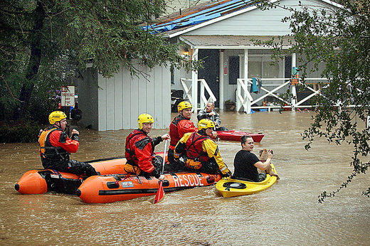 |
| Rescue efforts in Felton. photo: Dan Coyro - SC Sentinel |
Rain will be heavy this afternoon and evening, tapering a bit after bight fall. By the early morning hours on Friday, the AR will be well south of us, and we will only have some lingering showers. The morning commute will still be something to contend with, as that will be prime time for landslides to again close the road. A massive landslide near Surgarloaf is still blocking most of the north bound lanes, and is not expected to be cleared until at least Monday. Luckily we are going to see 5 or more days break in the rain. We can expect up to three inches here in town before the rain subsides tomorrow. More in the mountains. With some luck, this thing will move quickly and keep us below an inch of new water. We could use the break.
Friday begins with showers, and ends with maybe some misting. Cooler air moves in during the day with a cold front. Friday night, the starts will come out and temps will drop into the low 40s, after hanging in the mid 50s all week. It will feel crisp Saturday morning, but that sunshine will feel so nice. As it stands now, we can expect sunshine and fine warming weather through next Thursday. My hopes for hitting the 70s looks squashed, but we stil can expect mid to upper 60s through the middle of the work week. It is not much time to dry out before the next set of systems, but it is better than nothing.
Wednesday, February 8, 2017
5.83" in 24 Hours.
It is kind of hard to track this much rainfall. I've seen three gauges go down on the west side this week and last. One of them was certainly off when it recorded over 50" of rainfall yesterday. A station at Monte Fiore near Scotts Valley recorded 5.83" of rain in a 24 hour period beginning at 3:48PM on Monday. Actually, the vast majority of that fell prior to 11AM on Tuesday, so really a 19 hour period. That is a tremendous amount of water, and one result was a swelling and flooding of the San Lorenzo River.
Since Sunday, we have collected 7.37 inches of rain in Scotts Valley, and over 8 inches at the summit. Today and tomorrow morning we are in for a little break. Light misty drizzle could continue today, but not expecting much more than a few tenths of an inch. We could see a few moderate squalls. It is warm out there, with lows never dipping below 56F last night on the west side. Pin pointing when the rain will come back in is not easy. The GFS models are suggesting a break until mid day Thursday. The NWS service is forecasting heavy rain returning tonight after 10PM. That is a pretty big gap. I'll split the difference and say that heavy rains will move in early tomorrow morning. Caveat here is we may see a mild morning. Regardless, we are looking at one to several inches of more rain by the end of day Friday. There is potential here for a a five day total of nearly 10 inches of precipitation. There is potential here for a record breaking year. Just read about that in the long term.
 |
| The mighty San Lorenzo. Photo: Ed Schuhl, Cohabitat Building. |
Since Sunday, we have collected 7.37 inches of rain in Scotts Valley, and over 8 inches at the summit. Today and tomorrow morning we are in for a little break. Light misty drizzle could continue today, but not expecting much more than a few tenths of an inch. We could see a few moderate squalls. It is warm out there, with lows never dipping below 56F last night on the west side. Pin pointing when the rain will come back in is not easy. The GFS models are suggesting a break until mid day Thursday. The NWS service is forecasting heavy rain returning tonight after 10PM. That is a pretty big gap. I'll split the difference and say that heavy rains will move in early tomorrow morning. Caveat here is we may see a mild morning. Regardless, we are looking at one to several inches of more rain by the end of day Friday. There is potential here for a a five day total of nearly 10 inches of precipitation. There is potential here for a record breaking year. Just read about that in the long term.
This weekend is going to be awesome. The storm moves south on Friday, hitting the drought stricken portion of the state (we can say that now). Mid to upper 60s warming to low 70s on Monday. We could be looking at 5-7 days of sunshine. Yipee! After that there is a a lot of agreement on the models that we could return to a very wet and wild, and possibly cold run of weather. Winter is here. I would seriously take this coming week to dry off, and get some sunshine on your skin. Prep, and prepare, as this next round will be falling on this supersaturated soil, with our rivers and lakes already filled. We've been lucky in my neighborhood with only one brief power outage this season. That can't last for ever.
Highway 17 is has opened back up today, after closing due to a massive mudslide yesterday. Many commuters spent the night in San Jose as Highways 9 and 152 closed as well. Travel over the mountain on back roads is not safe during these systems, so please stay safe when we see these closures. A large truck was hit by the Highway 17 landslide and road over the barrier into the opposite lane. Serious power here. Plan for traffic delays on Friday.
Tuesday, February 7, 2017
Four Before Sunrise.
It is really hard to track the rain fall as gauges seem to be going down daily. We recorded several inches yesterday day her on the west side and as of 6:30 this morning the same gauge is recording another 10 inches. That is not happening. It has been raining hard, but not like that. The Scotts Valley gauge is now totaling 3.75 inches since yesterday morning. That seems more like it. Near the summit, the total is exactly four inches. It is currently 57F on the westside. A very warm night. Winds have not been that bad, with gusts to near 20mph in town, and up to 30mph near the summit, and up to 40mph at Long Marine Lab. Could be worse.
Rain continues today. NWS calling for one to two more inches. We have already received a lot. Looking at the infrared and water vapor, it looks like more is in fact streaming in. Plan for a very very wet day, with the potential for some real flooding to occur. Use extra caution on the mountain roads, and plan for delays. This is a doozie of a day. We might exceed a half foot of rain in a 48 hour period. At this point we have received close to four inches in less than 15 hours. Onto already saturated soils. There is literally no where for the water to go except across the surface.
The aim of this AR event will remain centered near us through the daylight hours today. We may see a lighter period of rain through the first half of the day, with a resurgence from noon to sunset. The GFS is calling for another 3-4 inches by noon Wednesday. These forecasts are insane. Anyway, heavier rains in the afternoon, then the heaviest precip begins to shift south. By sunrise on Wednesday, we should see just some light, and sporadic rain. We could see a complete break in the rain by night fall tomorrow. Thursday could be the winner of the week, but another round os still expected for Thursday night and Friday. More on that tomorrow. Stay safe.
Monday, February 6, 2017
Wet, Warm and Windy.
Monday night is going to be a doozie. Just got back from a wonderful weekend on the snow with the family. Snow backs are in excess of 10 feet in the Kirkwood Valley. The mountain is heavily covered, with most typical slopes off the ridge line completely filled in top to bottom. This is the best it has been since 04/05 this early in the season. The year my son was born (10/11) was big was well, but it had a 6 week drought into mid February, then really turned on through June. With another 40 inches or more expected this week, it keeps piling up. But let's take a look at this week's weather.
Rain and warmth today. Not too crazy, as the first system of the week already moved through last night dropping a quick half inch on the west side. Over an inch fell along the summit. We drove 17 at the perfect time to get the most rain fall on my wind shield. It was dumping. Today will hit about 60F, then tonight we see some serious wind and rain. Winds will ramp up from the southwest a little after sunset, with local gusts upwards of 40 mph. Soon after those winds start up we will see a deluge. If you are a highway 17 commuter, Tuesday morning is going to be hellacious. Fully. Over night tonight, the NWS is calling for 1-2 inches of rain in Santa Cruz, with more in the mountains. That is a tremendous amount of water to fall on already very saturated ground. Combined with high winds, we could expect more downed trees, despite having already lost all the weak trees earlier this winter. And mudslides. At the very least, check for road closures before you go. Currently the forecast is for the heaviest rains from about 10PM Monday, through 10AM Tuesday. But it is not like either the wind or the rain let up much after that.
Monday night will drop to only 55F, and Tuesday will be in the low 60s. This is a very warm rain event, and snow levels will rise up past 8000 feet Tuesday. This will result in quite a bit of upper elevation run off, and we should expect rivers to swell back up toward flood levels. Rain continues through Tuesday night with a low again near 55F. Wednesday will be kind of nice, considering. Light rain, moderate winds, clouds and in the low 60s. Might be a good day to get outside. In fact, it will stay like that through Thursday morning. Then, the next system arrives. This one is looking a bit colder, but might take some time for that colder air to filter into Santa Cruz. Rain begins up mid day on Thursday and last into Friday. Details are sketchy, but it looks like by Saturday morning we should be in for a break.
All in all, we are looking at another 3-5 inches of rain over the next 5 days, with more in the local mountains. The Sierra Crest is looking at 7-15 inches of water equivalent, with much of that falling as rain. The highest peaks, above 9000 feet, could be receiving 10 or more feet of snow. Crazy. More details to follow. Stay dry and stay safe. Plan for power outages. And copious winds.
Thursday, February 2, 2017
Storm Days.
Yesterday was pretty damn nice out. Sunny at times, and with that warm. We took the remote control car out for a run around Lighthouse Field in the early afternoon. There are still some puddles to drive around, and the low spots are a bog, but the main paths were relatively dry. As we emerged from a grove and was headed to our car at about 3PM, we were greeted by very strong south winds. Soon after that a little rain started. The Farmer's Market was in full clean up mode when I showed up around 5PM. But the rain never really kicked in in earnest. Even this morning it is on again, off again. Still, we should expect some moderate rains through mid day today, tapering in the afternoon. We are at just over a quarter inch so far (.84" in Scotts Valley), and should expect nearly an inch in town. A few more up in the hills. Based on our hike about yesterday, plan for even this moderate rain fall to get those creeks up an running swiftly. And be watching for mudslide and urban flooding. It is winter.
It should remain cool, but not cold, with temps in the upper 50s today, and it never dropped below 50F last night. This will mean rain for Tahoe until later. By evening, we should have a fair break in the weather before the second round arrives before sunrise on Friday. Another warm night is expected. We could see another round of moderate rain here in Santa Cruz. Around mid day to evening a cold front will pass through, dropping temps a bit, and bringing with it frontal showers. Rain tapers overnight and by Saturday day break we should really only see a few sporadic showers. The forecast trend is for mostly clouds over the weekend, but very little chance for light rain until Sunday afternoon when the next system approaches. Of course, you need not be surprised is showers do persist over the weekend, as they are expected just to our north and south - so don't expect a beach day.
Currently it looks like more rain Sunday night into Monday, with another storm showing on Tuesday. Another inch or so with the Monday system. The Tuesday storm looks like we will just get brushed by the southern fringe, so lighter precip; but this storm is a strong one just to our north, so a shift of a few hundred miles could bring us a deluge. The rest of next week looks like high pressure will try to squeeze in from the south, pushing showery weather north. Hoping it is sunshine and not a week of clouds and showers. The long term suggests a return to a storm track for mid to late in the month.
Today's drought monitor release has seen another 6% drop (down to 20% of the state) out of Severe to Moderate drought. That was the biggest shift. We still have 1.87% listed Extreme, with 38% out of drought completely, and another 22% just Abnormally Dry. Moving in the right direction, and with more rain, we will continue to see improvements. Unfortunately, this storm will not reach south or east of LA, so drought will persist there.
Subscribe to:
Posts (Atom)