Monday, August 29, 2011

Over 6 Million.

Saturday afternoon image of Irene.  Huge.
Irene is now just a memory, but she has had a lasting effects.  The loss of power for over 6 million people for instance.  The estuaries along the east coast, especially inside the Outer Banks, have taken a serious blow.  It will take some time to determine the extent of the damage.  House in the sea, roads collapsed, city streets flooded.  This was no meager storm.  We could say that many were lucky that Irene decided to mellow a bit just before hitting North Carolina and rolling up the Mid Atlantic Seaboard.  But then again, lucky would have been a hard right hand turn, out to sea, sparing untold loss.

Growing up on the east coast, hurricanes always fascinated and excited us.  Once, Bob ran across Rhode Island and the Cape, and turned back on shore in Maine.  We had a 'cane party, while our wiser parents tied down the fort and headed for safer ground.  It was amazing to see the winds calm and then switch off shore as the eye passed.  And to watch the swells grow from nothing to huge in hours.  And diminish as quickly.  Irene was not a great swell maker for the east coast.  Just too close.  And too destructive to truly appreciate the beauty of the waves.  Still south Florida faired best, and actually missed the rain and the wind from the storm completely.  New Jersey got decent surf on Sunday afternoon after the storm passed north, and smaller swells are impacting Maine this morning.
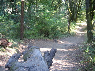
Smooth single track in Wilder Ranch SP.
Here in Santa Cruz, things remain fairly constant. We continue in the summer pattern of cool foggy nights around 55F and mild sunny afternoons reaching about 70F.  The marine layer if filling back in this week, after a brief warming trend that was experienced in the interior the past few days.  Low lying areas around the Bay should see a fair amount of fog this morning and through the week.  Expect coastal clearing to happen around noon or later.  Some zones will stay foggy all day.  While our local weather is none to interesting, regionally, we see some things happening.

Over the weekend, two waves of a broad low pressure moved through the Gulf of Alaska.  Most of the energy was deflected north, sparing rain for the coast south of the northern tip of Vancouver Island.  Regardless, this was not a typical summer system, and suggests that the north Pacific is coming to life.  This week sees a rebound of the typical high pressure.  But mid range and long range charts do look interesting.  Another series of more defined storms are to begin moving into the Gulf by this weekend and through the early part of next week.  We could even see rain reaching down into Washington by next Wednesday as these storms push ashore.  But that is way to far out to have any confidence in.  Beyond that, on the fantasy models, the east Pacific may have some well defined systems moving off of Kamchatka and slowly filling in across the entire North Pacific.  This would be interesting for mid September, and may be enough to push the first showers of the season across the Tahoe high country.  We will monitor and report back here.

All this talk of storms nearby has got to have some of you thinking about waves.  Yes, we are expecting a little push of NW groundswell to arrive later this week.  We should begin to see some mid period ground swell arrive on Tuesday evening and lasting through Wednesday.  Expect five foot surf or so.  Much better than what we have been getting, but that is nothing compared to the south swell that is right on its heels.  Very long period south swell should arrive mid day Wednesday and building to eight feet (or more at the best locations) on Thursday.  This is a very long period swell and will be packing a tremendous amount of energy compared to its height.  If you plant to venture out in the water the second half of the week, please know what you are doing and be smart.  Waves should begin to taper slightly on Friday and subside over the holiday weekend.  Should be some fun surfing over the next week.  More likely on the way if those storms move through the Gulf this weekend.

Small waves at the top of Pleasure Point.
Just a word of caution to all those gardeners out there. If you are living through the summer in a mild foggy zone like I am, watch out for molds.  Particularly devastating can be tomato late blight.  This fungus can easily take hold in these conditions and destroy your (and your neighbor's) crop.  More information and picture are here.  I mention this here, as we had to pull out one plant recently.  It was sad as this was a wonderful looking paste tomato that I had been excited to try.  I guess we will make green tomato relish instead.  And hopefully we spared the other plants in the yard from having the disease spread to them.  We are in a holding pattern with most of our tomatoes, waiting for the warmth of late September to ripen them up.  On a very positive not, our Sungold 100s do not seem to mild the chill and we are harvesting 1-2 quarts a week.  Let the tomato fest begin.

For now, continued fog.  Heavy at times this week.  Expect the same for the holiday weekend.  If you are looking for sun, head inland.  We will be going to the Sierra to enjoy a few starry nights.  And the recent activity in the Gulf of Alaska gives hope to the change of seasons.  The good news is that before we get rain, we usually get a month or more of the best weather of the year down here by the sea.


Monday, August 22, 2011

Lowtide @ the Ogunquit footbridge, Maine
The surf must be flat (it is), because when I had a window open up last evening, I grabbed the bike and headed out to Wilder State Park.  With a paved bike path starting on the northern edge of town connecting the one mile to the park, it is all about easy access.  The weather is just about perfect for a bike ride in the late afternoon.  With the heavy marine layer sticking around until early afternoon, the air temperatures are staying mild.  Perfect for climbing.  I took a quick run, and only stayed on one set up trails, but things are looking great up there.  A lot of trail work has been completed since I last got on my bike in spring.  A bunch of grooming, and some much needed minor rerouting has really smoothed out the single track.  Actually, to call the rerouting minor is a little mild.  Some sections have had significant changes, making it feel almost like completely new trails.  And the fire road I was on was the fastest and smoothest I have seen it since four or five seasons ago.  If you like to mountain bike, get on down to Santa Cruz and over to Wilder.  It is riding excellently right now.  I know I am going to go out and explore some more this week.  And that should give you the surf forecast - pretty minor.

As for the weather, more gloom here on the coast.  We are not seeing much of a change to the current pattern, that is now going into its sixth week.  If only we could have some of that last April/ early May gloriousness.  Mid 50s at night and about 70F for a daytime high.  Fog lingering through the morning.  Clearing sometime between 11am and 1pm - if at all.  Tuesday looks to be the highlight of the week, with slightly warmer temps and the fog burning off a tad bit earlier.  If we are lucky.  The marine layer is not going to be quite so invasive this week, so areas just off the water might be spared.  That is good news for the Santa Cruz mountains, as well as areas like Palo Alto.  As usual, Los Gatos should have great weather this week.  And the inland valleys continue to see hot days in the 90s and mild evenings in the mid 60s.  If any of you folk need to cool off, just jet on over to Santa Cruz.  The air conditioner is always on this season.

Thunderstorms rolling into Cape Porpoise Harbor.
Diffuse low pressure continues in the Gulf of Alaska this week.  Most storms will be forces northward by ridging before impacting the coast of British Columbia.  Only chance of rain we see around the bay will be drizzle from this fog layer.  Still, it is interesting to see the summer high pressure suppressed for an extended period of time in August.  Small chance for minimal wind swell starting some time tomorrow from these storms.  Minimal is the operative word.  Perhaps of more pressing interest os Hurricane Irene in the Atlantic.  Currently located just northeast of Hispaniola, Irene has sustained winds of 70 knots.  And she is broad.  Irene is forecast to intensify to a Class 3 storm and run over the Bahamas late Wednesday, into Thursday morning.  Currently, models have her tracking east of Florida on Friday and running into the South Carolina coast line on Saturday morning with winds sustained at 100 knots.  It should be mentioned that the forecast track for Friday and Saturday is a bit suspect, as the 5 year average error at those forecast times are over 200 miles.  This storm could run a ground much early, or be way out to sea.  Still, for any who have interest on the south east coast, this is something to monitor.  As a note, this track does not do a great job for producing swell either.  The Outer Banks, though, should be over powered with swell.

Southern Maine estuary.
This weather is having its effect on produce.  Apples are in early this season.  That I do not mind.  Typical hot weather crops are not having a great year, but then again, not as bad as last year.  Tomatoes are very slow to ripen, and many are starting to see some molds.  One of your best organic defenses against mold is copper spray, as well as the removal of effected plant parts.  Still, it is a battle between the slow ripening and the pest.  Lettuces are doing great, as well as other typical cold weather plants.  Peas are having a better than average summer season, especially if they were planted in the sunnier parts of the yard.  Our purple Brussles sprouts are doing decently, but even they could handle a bit more heat. On the other hand, cucumbers, beans and tomatillos that were started in May or June, have never really took hold, and are quite stunted.  But there is still time, and summer does not really come around here until mid September.  Hold on one more month.  It should be glorious again.

For now, cool and foggy.  Bring a hoody to the beach.  Ride a bike.  Go for a run or a hike.  If you are still looking for an outdoor activity, try berry picking.  Dress warm, pick away and you will be rewarded.

Wednesday, August 17, 2011

A Stir in the North. Otherwise, Things Remain the Same.

Cape Porpoise Harbor, Maine.
Santa Cruz has been pretty much the same every day for the past week.  Sure, the fog has cleared earlier some days, but every morning begins with the clouds.  Monday was perhaps the best day, with sun on the west side of town by 8AM.  Most days, we wait until late morning, or even early afternoon.  One day, the sun never did come out.  Today and the next should warm up a bit, with highs in the mid 70s.  Otherwise, expect high 60s to 70F for day time highs.  Lows should be in the mid 50s for the coming week.

Lobster Buoys. 
What is of interest is the going ons in the Gulf of Alaska.  We saw a fairly strong trough move through the Gulf and into the Washington coast over the past few days.  While not unheard of for August, this was a strong showing.  And it did result in some cooling in the valley and mountains.  It did not much effect our weather here on the coast except for some wind.  While the usual high pressure is making its rebound starting today, the forecast calls for two strong waves to move through starting as early as Friday.  Again, we will not see much weather change from these systems, as they are much further north than us.  Still, if they develop as modeled, they are interesting.  The first, and stronger of the two, begins setting up in the Bering Sea on Friday, with pressure dropping below 980mb.  That is pretty darn strong for August.  Then, the bulk of the system shifts into the Gulf of Alaska on Saturday, as it weakens and broadens a bit.  A second wave is to follow the same path about a day behind.  High pressure does not again take control of the Pacific until late next week.  Very interesting, and perhaps a sign of a change in the seasons could be a bit early this year.

Or, this could just be a blip.  Still, if it does come to pass, we could see significant wind swell and minor ground swell coming from the north west.  Not a bad thing, considering the small south swells, that we have been lucky enough to have, are coming to an end.  And on the long range fantasy models, we see more low pressure moving across the north Pacific to start off the month of September.  All of these storms are expected to stay well north of our area, so no hopes of rain any time soon.  But Seattle and points north could begin to see some moderate rain.  Some parts of the British Columbia coast can expect heavy rains over the next week.

Nubble Light, Cape Neddick.  York, Maine.
It is a good thing we are staying dry because tomato season has just begun for the coastal communities.  Our Sungolds (small cherry tomato) are just starting to go off.  The vines are huge, with many over seven feet long.  And heavy with fruit.  Now the ripening process is to begin.  You may have tomato plants yourself, and you may hit a point in the next month when you have more  tomatoes than you know what to do with.  We just end up putting them in everything.  Salad, salsa, pasta, curry, whatever.  If you still have some sitting around, you can always can some for the winter.  If you do not want to go through all that trouble, and have some freezer space, try this.  Score the skin of the tomatoes before placing them in boiling water.  Boil for 90 seconds and transfer to ice water.  Allow them to sit for 5 minutes.  Remove and peel the skin off.  If done correctly, the skin will already be separated from the flesh.  Either keep or remove the seeds.  Cool and place in a freezer bag.  Freeze until needed.  They will be great for sauces and pasta come February.  You can never have too many fresh tomatoes.

Remember to water your gardens.  Even with this fog, the dry afternoon air and winds help drain that soil.  Cucumbers, beans and squash especially need a regular watering.  And that will not change for some time.  For now, foggy mornings and sunny afternoons prevail along the coast.  Oh, and local pics will return soon.

Thursday, August 11, 2011

Still a Typical Summer. Foggy Mornings and Sunny Afternoons.

So after nearly a month of traveling around New England and experiencing their hot humid days and amazing afternoon thunder and lightning storms, we return to beautiful Santa Cruz to find a warm sunny afternoon followed by a cool foggy morning.  Who could have guessed?  Following the summer weather here is generally a no brainer, and you can usually make a smart bet without ever even checking a forecast. A little different back east where each day can have significant difference.  Glad to be back, but will sort of miss the humid 90F beach days with 68F water temps.  It is hard to explain to friends how the Pacific can actually hurt as you step into it in Santa Cruz.

So what is in store for us central Californians?  Santa Cruz can look forward to lows around 55 and highs around 70 for the foreseeable future.  Heavy fog fills in every night and sticks around through the morning hours.  Clearing late morning to early afternoon and then sun and some warming.  As soon as that sun dips, the temperatures follow (no more hot summer nights for us).   Not very exciting weather, for sure, but not terrible.  Remember the six weeks last summer that we never really saw the sun along the coast, and even typically warm and sunny locales like Palo Alto had high cloud fog through early afternoon?  That pattern never really set up this summer despite the pool of cold water hanging just off our coast.  In part, this is because the interior did not really set up the heat pump from the southwest.  Sure, the central valley is warm or hot even with daytime highs in the low 90s, but the air mass is cool when nights are dropping into the high 50s.  Hence, no intense fog.  But still enough to keep us damp.

Around the bay, low lying zones near water are seeing morning fog, just like us in Santa Cruz.  Los Gatos seems to be the winner, as a little elevation, and being backed to the mountains is giving it sunny mornings with mid day highs around 85F.  Perhaps this is the week to do a little shopping around their downtown.  If shopping is not your thing, this weather is good for just about any outdoor activity besides sunbathing.  You have a big window for hitting up the mountain bike trails around Wilder.  Those sun exposed meadows do not bake in the sun until the sun comes out.  Or is you want to escape the fog, head up to the Sierra.  The days are actually much warmer up there this time of year, and you can expect high 70s and low 80s around the lake this week.  And there is still plenty of patch skiing going on at the higher elevations.

The surf is looking small and decent this coming week, with plenty of action in the water.  Northerly wind swell will offer up most of the energy.  Some minimal typhoon swell may fill in and last through the week.  This will be from the WNW, long period, small and inconsistent, but will mix with other swells to generate some fun waves.  Also, we keep seeing some small mid period south energy filling in around Santa Cruz this work week.  All in all, waist to chest high surf should be the call.  And mornings should be glassy.  We do have a chance for some mid sized south swells to arrive for the weekend.  So, at least you can get out and get some exercise.  You may even have a little fun.

In short, nothing too exciting.  Should stay this way for a while.  But fall is just around the corner, and we should begin seeing some pattern changes soon.  Check back here later this week.  I will assess our garden more tomorrow, but it looks like tomato season has begun along the coast.