Sun. Surf. No Wind. Sunsets. Warm. No Rain. I tell ya, we have some of the best winter around. While a good portion of the rest of the country is wet, cold, or both, we are looking pretty fine. I just got off the plane from Virginia, where the weather was pleasant enough, if a bit crisp. It was warm when we got home today. The surf was pumping. And the sunset was another winner. You've got to love it here. I really enjoyed my trip, but it always nice to come home. And today delivered. Thing is, Santa Cruz delivered all week while I was gone. And it will deliver again all next week. Again, while I'm gone. And when I come home a few days later, it will still be delivering. So, when does this all change?
Mid 60s, and little wind. Some high clouds. Warmest Sunday. And again by Thursday. Nights in the upper 30s. Looks like it should continue like this through next weekend at least. Only bummer about this weather, is we really do need to get some water this winter. GFS keeps brining it to us starting around the 8th or so. Euro is a touch later. Been that way for several runs now. But no one is holding there breath. Before that, the weather stays pretty much the same. Another round of swell fills in tomorrow, while what is in the water is still sizable enough to have town breaks looking fun. Another round arrives Monday, and another Thursday. Oh, and the wind looks light through the period. So basically, surf is up.
I'll take a look at the forecast models over the next few days and see if we get some more agreement and consistency as we get closer. As for now, get out there and seize the day folks. It is damn awesome out.
Friday, December 27, 2013
Sunday, December 22, 2013
High and Dry.
Hey folks. I'm headed out of town in the morning to go visit family. Too bad, as the weather is ideal mid winter bliss. Cool, even crisp, mornings in the upper 30s. Afternoon highs in the low to mid 60s. Slight warming trend through Christmas Day. Nestled up against the south facing cinder block wall in the CostCo parking lot, it could top 70F. Not bad for December 25th. And the surf will be pumping this week as well, as a new NW long period mid size swell peaks on Monday and tapers through the first half of the week. Another shows as a gift from Saint Nick. Slightly cooler into the weekend. Sunshine prevails, other than just enough cloud cover to make the early winter sunsets pop.
 |
| The weather outside is not frightful. |
Wednesday, December 18, 2013
Quick update this morning. GFS has us dry, with almost a quarter inch (say 2 inches of snow) along the Tahoe peaks. Almost a half inch for L.A., and even more for the Socal mountains. Mammoth could get up to three quarters of an inch of precipitation. Not a lot going south, but the bulk of this will be well south and east of us. Feels like rain this morning though. I think that is just the warm still air pooling before the cold north west breeze develops. But it is moist. Still a slight chance for rain tonight and tomorrow.Could be a good few days to get some errands done, or find something to do inside. We might hit up the Monterey Bay Aquarium Thursday. We like to park for free out along the coastal bike path, and walk back to the aquarium while looking for seals, otters and birds. Memberships are a great holiday gift to give to a family (I should know, we have received this gift for two years in a row). And tax deductible, for you finance savvy folks out there. In April, or May, the Tentacles exhibition will be open. Another thing to do inside, starting this Friday, is the train exhibit at the Santa Cruz Museum of Art and History. If your young one, or you yourself, love a good model train set up, this is the thing for you. And it is free, but, hey, membership here is less expensive, and supports a good place. We built snow flakes there recently.
Okay, likely no rain. But still plan for a drizzle, or cool ominous clouds, at least. Clearer and warmer Friday. Weekend looks fine. Could see another warm up.
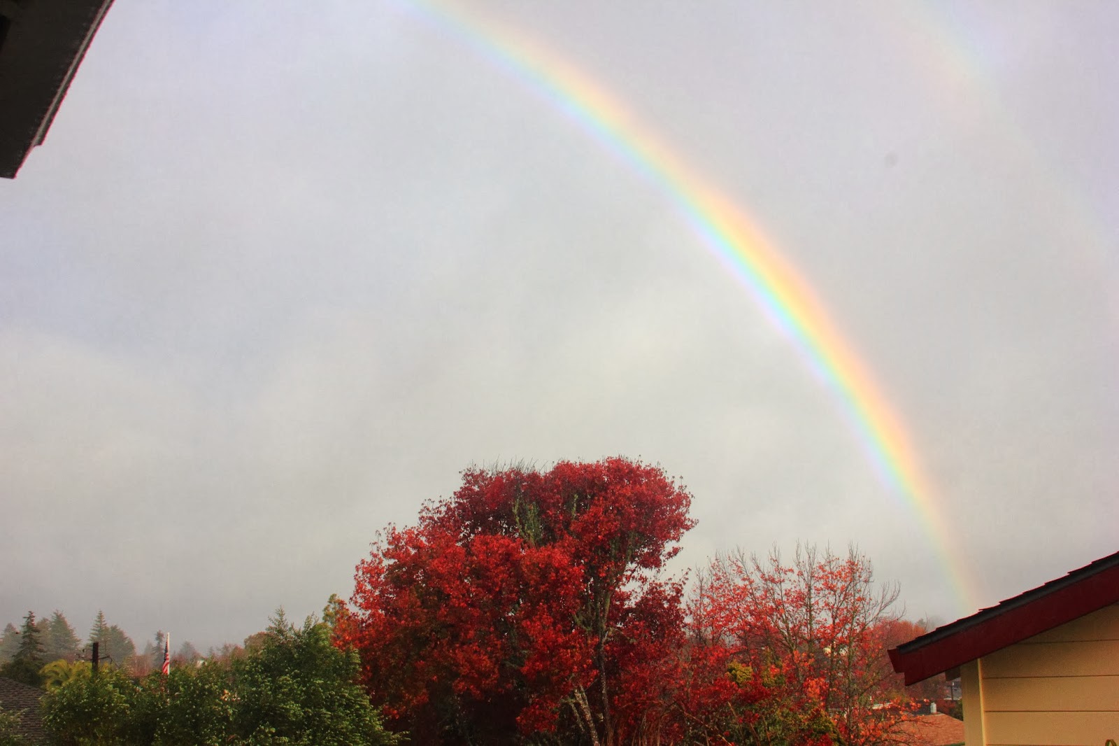 |
| Autumn storm brings color to the sky. Hard to see, but that was a double rainbow, dude.... |
Okay, likely no rain. But still plan for a drizzle, or cool ominous clouds, at least. Clearer and warmer Friday. Weekend looks fine. Could see another warm up.
Tuesday, December 17, 2013
Looking mostly dry. Mostly.
I wanted to wait till this morning to get a better feel for the trend this week. On Sunday, the GFS shifted to a much wetter, and a touch cooler, solution. Since then it has been slowly backing off from that toward a drier, if not dry, solution. Now we are two days out, so lets take a closer look at it. Pleasant day today. Not quite as warm as yesterday, but still quite nice. Speaking of yesterday, if you were watching TV at sunset, you were doing it wrong. One of those magical evenings out there. I was lucky enough to be in the water along West Cliff when dark slowly settled in. Such an absolutely beautiful late autumn evening. Upper 60s today in the best corners of town, with a thin high haze, and maybe some low fog along the water. That fog could fill in tonight, as the winds are basically calm out there. Wednesday will start off quite mild in the low to mid 40s. But it won't warm up much, as a cold north west breeze develops through the day. Highs stay in the 50s.
So, there is a pretty solid swell running right now. At least solid for this anemic season. And with these calm conditions, the surf is breaking really nicely. Should be another solid day today. As the swell backs off, and the wind kicks up, the conditions will deteriorate. But not to worry. We will get some big windswell mid week. As the weather calms late in the week, more small mid period swell arrives. By next week, it could be big again. And it looks to stay rideable through next week. Finally, maybe the season has started up.
So the weather calms. Thursday could be a stormy day, with some wind and clouds. We could even see a bit of rain, but it does not look likely at this point. The Sierra Crest still might squeeze out a few inches of snow. But it is mostly only going to bring that colder air, with lows back in the 30s and the highs back in the 50s. Luckily, it will not quite last like the last bought of cold, as high pressure quickly builds and pumps back in the warm air. Not like yesterday warm, but warm. Low to mid 60s starting Saturday. And no signs of cooling or storms in the mid term. Bubble of high could keep us dry through the year. If you collect your own rain water, you should be conserving right now. Until winter starts, we really can count on anything.
 |
| Stealing one of my wife's pics. Persimmons, UCSC Campus Farm. |
So, there is a pretty solid swell running right now. At least solid for this anemic season. And with these calm conditions, the surf is breaking really nicely. Should be another solid day today. As the swell backs off, and the wind kicks up, the conditions will deteriorate. But not to worry. We will get some big windswell mid week. As the weather calms late in the week, more small mid period swell arrives. By next week, it could be big again. And it looks to stay rideable through next week. Finally, maybe the season has started up.
So the weather calms. Thursday could be a stormy day, with some wind and clouds. We could even see a bit of rain, but it does not look likely at this point. The Sierra Crest still might squeeze out a few inches of snow. But it is mostly only going to bring that colder air, with lows back in the 30s and the highs back in the 50s. Luckily, it will not quite last like the last bought of cold, as high pressure quickly builds and pumps back in the warm air. Not like yesterday warm, but warm. Low to mid 60s starting Saturday. And no signs of cooling or storms in the mid term. Bubble of high could keep us dry through the year. If you collect your own rain water, you should be conserving right now. Until winter starts, we really can count on anything.
Sunday, December 15, 2013
Maybe a shower?
I sure need one. his mornings run of the GFS has the storm for Thursday looking much more impressive, but still staying mostly away from us. Out to sea it the thought today. But this scenario would bring us some clouds and light showers for Thursday. I'll keep an eye on this, and give you a more in depth look tomorrow night. This system is to split from the Jet Stream, so it will really be quite unpredictable, but we will try to make an educated guess. Right now it seems wise to plan for a little wetness Thursday. Not too much though. And not enough to make for some real snow. In the meantime, if you use Instagram, follow therealweather for current up to date pictures of our weather. Maybe I will even tweet soon.
Anyway folks, if the storm does dive down the coast, and pick up moisture, it will likely bring cooler weather by Wednesday. Still super nice on Monday. Warm, even. Milder, but still fair on Tuesday. Cooler Wednesday, and maybe a short drizzle for Thursday. Rebound into the low 60s for the weekend. Stay tuned.
 |
| More hiking trail. Henry Cowell Redwood State Park. |
Anyway folks, if the storm does dive down the coast, and pick up moisture, it will likely bring cooler weather by Wednesday. Still super nice on Monday. Warm, even. Milder, but still fair on Tuesday. Cooler Wednesday, and maybe a short drizzle for Thursday. Rebound into the low 60s for the weekend. Stay tuned.
Saturday, December 14, 2013
Great time to work on a holiday tan.
Seriously, this weekend and the start of next week look splendid for mid December. We have moved solidly into the 60s for today, with upper 60s for Sunday and moving into the 70s on Monday. Over night, with the calm winds, it is still pretty chilly. Upper 30s, but still some frost development. We saw frost still on the ground at noon, both Wednesday and Thursday, tucked up near the red woods. That is some cold folks. Mornings will be slightly warmer during the start of the week. Say, low to mid 40s. But not for long. More cold is on the way. Get your tan on while it is warm enough to remove some garments. No rain in the forecast.
After Monday, it will not be as warm, but it won't be cold. Mid 60s. Then Thursday, a mostly dry system crashes south and brings us another round of cold air. Lows in the mid 30s. Highs in the upper 50s. Not quite as cold as the last system, but chilly none the less. This system once looked like it would bring some rain somewhere. Now we will be lucky to squeeze and inch of snow out of it at high elevations. And no real water is showing up in the mid and long term right now. It could be a very dry month. The ski resorts could really use a good dump before the holidays, and the state could use the water. Fingers crossed, but it does not look likely. Well, back to completing work in the yard. In the meantime, the surf is real good, with finally some swell and nice clean conditions. Bigger swell for Monday. Wear a hood, It is cold out there. I'll post up again early next week, looking at the surf and coming cold. And I'll keep an eye out for rain. Like I said, this would be a good weekend o be up skiing. Nice weather, and the snow we do have is fun, and it is only getting older. Hell, Kirkwood opened Chair 6 today, so Tahoe does have some steeps on offer.
 |
| Get it while it is good. Kirkwood ridge line. |
After Monday, it will not be as warm, but it won't be cold. Mid 60s. Then Thursday, a mostly dry system crashes south and brings us another round of cold air. Lows in the mid 30s. Highs in the upper 50s. Not quite as cold as the last system, but chilly none the less. This system once looked like it would bring some rain somewhere. Now we will be lucky to squeeze and inch of snow out of it at high elevations. And no real water is showing up in the mid and long term right now. It could be a very dry month. The ski resorts could really use a good dump before the holidays, and the state could use the water. Fingers crossed, but it does not look likely. Well, back to completing work in the yard. In the meantime, the surf is real good, with finally some swell and nice clean conditions. Bigger swell for Monday. Wear a hood, It is cold out there. I'll post up again early next week, looking at the surf and coming cold. And I'll keep an eye out for rain. Like I said, this would be a good weekend o be up skiing. Nice weather, and the snow we do have is fun, and it is only getting older. Hell, Kirkwood opened Chair 6 today, so Tahoe does have some steeps on offer.
Wednesday, December 11, 2013
Warming.
No a whole lot, but it is there. Yesterday morning seemed about the coldest for the spell. At least in my yard, and based upon my very scientific 'frost on car' visual check. Anyway, today will move into the mid 50s, and tonight we will stay in the mid to upper 30s. So, yeah, right toasty. The real news for today is the warming that might show for the coming weekend. The rest of the week will like kind of like today. Perhaps a touch warmer each day. Highs for the weekend could be in the mid 60s and even warmer for Sunday and Monday. It will depend on how this high pressure sets up over us. But at the very least, we are in for a run sunshine.
Don't get me wrong. It is still cold out there. We saw frost crystals still on the ground at 11AM in Harvey West Park. Now, this is a spot that rarely sees the sun this time of year, but still, that is cold. The ground actually felt semi frozen there. But, with a little luck, we could be pushing 70F in some parts of town by next Wednesday. If that comes to pass, it will feel positively warm. I might just head to the beach. In the meantime, the surf is running fairly small, and fairly clean. Size should pick up later in the week, and we could see chest to head high surf through the weekend, with maybe a bigger pulse on Monday. With the calm, and warm, weather, it could make for some fun surf.
Next chance at a weather change looks to be late next week. If you have been reading this fall, you know my confidence in the mid and long term is very, but I thought I'd give this a mention, as it has shown on the models several runs in a row now. Basically, an Alaskan system could break through the high pressure, bringing another round of cold air and rain for late next week. Or not. Check back here to see how things start to pan out over the next few days.
 |
| The Sierra gets a blanket. Check it out here. |
Don't get me wrong. It is still cold out there. We saw frost crystals still on the ground at 11AM in Harvey West Park. Now, this is a spot that rarely sees the sun this time of year, but still, that is cold. The ground actually felt semi frozen there. But, with a little luck, we could be pushing 70F in some parts of town by next Wednesday. If that comes to pass, it will feel positively warm. I might just head to the beach. In the meantime, the surf is running fairly small, and fairly clean. Size should pick up later in the week, and we could see chest to head high surf through the weekend, with maybe a bigger pulse on Monday. With the calm, and warm, weather, it could make for some fun surf.
Next chance at a weather change looks to be late next week. If you have been reading this fall, you know my confidence in the mid and long term is very, but I thought I'd give this a mention, as it has shown on the models several runs in a row now. Basically, an Alaskan system could break through the high pressure, bringing another round of cold air and rain for late next week. Or not. Check back here to see how things start to pan out over the next few days.
Monday, December 9, 2013
Continued Cold, but Slight Warming will feel nice.
Man is it chilly out there. Last night I pulled into the driveway around 10pm. It was 35F. Colder than 10PM on Thanksgiving, at 7800'. At 8AM, at 7800 feet, it was -9F. Even colder in the high elevation valleys. South Lake was -15F. Lucky for us, we live in sunny and warm California. The real cold was in the interior of the country where temperatures as low at -40F (and colder) were recorded. Mornings will remain cold, but they will slightly moderate by the end of the week. Daytime temps will be on the rise and we are in for a stretch of sunshine. About 50F today. Maybe a touch warmer. Clear and cold tonight with a freeze warning in effect. Continue to care for the needy people, pets and plants. Maybe take a moment and check in on a fellow human being. Some cold folks over the past few nights. Tuesday will be warmer still, clocking in at about 55F.
Wednesday morning will not be as cold, but still, some areas may drop below 32F. Still watch those plants. The rest of the week it looks like lows in the mid 30s and the highs in the upper 50s. The weekend will be warmer still with lows about 40F and highs about 60F. Right toasty. High pressure is setting up over the west and we should be storm free for a week or more. So, let us check in on the snow. Tahoe area resorts received from 1 to 3 feet of very light, dry snow from Friday's storm. If this were wet, heavy snow, it would be a big game on. But it helps. So does the cold and snow guns. Kirkwood is now running 3 lifts, with both on and off piste zones open, offering a nice, small variety of skiing options. I hear Sugarbowl has decent natural coverage as well. Most of the other resorts are mostly operating on manmade surfaces at this time. Northstar has a lot of groomed mileage, and with Burnout now open, at least something to develop leg burn on. I tell ya, that is one of the best places to hit up in White Ribbon Season. No storms on the horizon, and what looks like a relatively dry December has some folks worried. I say go on up and hit it now. Now, through this coming weekend, the snow should hold up nicely. Cool days keep the natural stuff in decent shape, and cold nights allows for the guns to blow. We need more to see the resorts really pop open, but we have a good start. Fingers crossed, but to be honest, I am not minding the though of another ten days of sunshine. And maybe a little bit of warmth too.
 |
| San Lorenzo River, Henry Cowell State Park, Felton, California. Late Autumn. |
Wednesday morning will not be as cold, but still, some areas may drop below 32F. Still watch those plants. The rest of the week it looks like lows in the mid 30s and the highs in the upper 50s. The weekend will be warmer still with lows about 40F and highs about 60F. Right toasty. High pressure is setting up over the west and we should be storm free for a week or more. So, let us check in on the snow. Tahoe area resorts received from 1 to 3 feet of very light, dry snow from Friday's storm. If this were wet, heavy snow, it would be a big game on. But it helps. So does the cold and snow guns. Kirkwood is now running 3 lifts, with both on and off piste zones open, offering a nice, small variety of skiing options. I hear Sugarbowl has decent natural coverage as well. Most of the other resorts are mostly operating on manmade surfaces at this time. Northstar has a lot of groomed mileage, and with Burnout now open, at least something to develop leg burn on. I tell ya, that is one of the best places to hit up in White Ribbon Season. No storms on the horizon, and what looks like a relatively dry December has some folks worried. I say go on up and hit it now. Now, through this coming weekend, the snow should hold up nicely. Cool days keep the natural stuff in decent shape, and cold nights allows for the guns to blow. We need more to see the resorts really pop open, but we have a good start. Fingers crossed, but to be honest, I am not minding the though of another ten days of sunshine. And maybe a little bit of warmth too.
Saturday, December 7, 2013
Cold Weekend, but things clear out early.
The storm has pretty much passed for us here in Santa Cruz. Clouds still block the view to Monterey, so they could have more morning showers. Radar shows there is still a little bit of action to our west, so we could still see some light showers sporadically this morning. Go downtown and enjoy the holiday parade. Much better out there than forecasted. But bundle up. It is still cold. And more cold air filters in tonight, although, it does not look like it will be quite as chilly as expected. Low 30s for us in town, maybe dropping to the upper 20's in the local mountains. The inland valley will be freezing, with extended periods in the low 20s. We might have some citrus issues from this chill.
Sunday we struggle to break into the 50s again. Slight warming trend for the coming week. Models are all over the place for the weather late in the week, so I will likely watch a few runs and update for that on Monday. Right now I am just enjoying the morning sunshine and the fact that this storm cruised through our area pretty quickly. I doubt we even got a 1/4 inch yesterday, let alone the 1/2 inch the GFS called for. While this system did speed through our area, it has settled down in the Sierra where a foot or two fell last night, and more continues to fall. Expect those ski resorts to start opening up more terrain. It is very light blower snow, so it will not get a lot of the steeper and rockier stuff to pop, but you probably will be able to ski a bit more than the white ribbon. I might head on up to check it out tomorrow. It is not like the surf looks all that promising this weekend. Maybe a small swell for Monday. And I know some of you like a wet bike trail, but I don't need another cleaning project on my hands. More on Monday.
 |
| A great place to be after, or during a rain. Among Redwoods. Henry Cowell SP. |
Sunday we struggle to break into the 50s again. Slight warming trend for the coming week. Models are all over the place for the weather late in the week, so I will likely watch a few runs and update for that on Monday. Right now I am just enjoying the morning sunshine and the fact that this storm cruised through our area pretty quickly. I doubt we even got a 1/4 inch yesterday, let alone the 1/2 inch the GFS called for. While this system did speed through our area, it has settled down in the Sierra where a foot or two fell last night, and more continues to fall. Expect those ski resorts to start opening up more terrain. It is very light blower snow, so it will not get a lot of the steeper and rockier stuff to pop, but you probably will be able to ski a bit more than the white ribbon. I might head on up to check it out tomorrow. It is not like the surf looks all that promising this weekend. Maybe a small swell for Monday. And I know some of you like a wet bike trail, but I don't need another cleaning project on my hands. More on Monday.
Friday, December 6, 2013
Rain Overnight.
Coming in after sunset, although clouds could fill more this afternoon. Onset before midnight, with heaviest rain subsiding just about daybreak. Rain tapering through the day. Cold. Colder again tomorrow night, with temps forecast below freezing by early morning. Will depend on cloud clover. Less means colder. Really try to get out there and protect your loved ones. This will be the coldest morning yet. Sunday will be a chilly one. Warming through mid week. More later today when I have a chance to sit.
Evening Edit: I felt the first drops around 3:30 today, and we had a steady rain develop by night fall. Brunt of the system is still to hit later tonight, but it looks like we received precipitation from a few forward bands. I can hear a steady pitter patter on the roof top. Look around the local hills tomorrow for snow on top. Could be a beautiful one, if chilly. Sunday still looks cold, and we could drop below freezing for a few hours, even right up to the coast.
 |
| Along the trail. Henry Cowell SP. |
Evening Edit: I felt the first drops around 3:30 today, and we had a steady rain develop by night fall. Brunt of the system is still to hit later tonight, but it looks like we received precipitation from a few forward bands. I can hear a steady pitter patter on the roof top. Look around the local hills tomorrow for snow on top. Could be a beautiful one, if chilly. Sunday still looks cold, and we could drop below freezing for a few hours, even right up to the coast.
Thursday, December 5, 2013
Splitting the difference. Rain should begin around night fall Friday. Wet Saturday.
The GFS continues to hold off on the start of rain, but other models and outlets call for rain by mid day Friday. Everyone agrees that there will be rain. NWS backed off on the timing as well. All in all, it looks like a fast, quick storm, that will drop a decent amount of rain over night. Showery weather breaks apart during the day, and we could even see some sun (fingers crossed) by afternoon. But with a good half inch expected, the ground will be fairly wet on Saturday. And it will be breezy, as well. Cold air follow behind the storm, and if those sky is clear, we could dip down into the 20s for early Saturday morning. Brr. We could be stuck in the high 40s for Sunday, but at least the wind will back down. Brrrrrrrrr. Much warmer on Monday, but still in the mid 50s. Low to mid 60s by mid week, which will feel right warm after these days. But we could be looking at another storm to finish off the week. Folks, this is going to feel like a winter weekend. Be prepared.
I'll take a final look at this storm, and the coming week tomorrow morning. For now, stay bundled up, and keep watching out for your plants, pets and folks living outside.
I'll take a final look at this storm, and the coming week tomorrow morning. For now, stay bundled up, and keep watching out for your plants, pets and folks living outside.
Wednesday, December 4, 2013
Model slows approach.
Just a quick one today. This morning's run slows the approach of the system for the weekend. Rain looks to develop sometime on Saturday, likely in the morning, and lasting through the day. This keeps the system over water longer, and allow for it to hit us more fully. Could be a pretty wet day. Heaviest rain presently looks to be around nightfall, with things fairly cleared out by Sunday. Freezing levels could drop below 2000 feet, which allows for some snow locally. It would be nice if we could see some on the peaks in the morning.
It should be noted that the NWS still has this coming in on early Friday, about 30 hours before the GFS. That is super significant given we are only 36 hours out from the earlier arrival time. Something to monitor. We are looking at a half inch of liquid as far south as at least Carmel. Well over in inch in the Sierra. We could get some decent snow this weekend, especially with the cold. Not really the sloppy base builder we need, but better than nothing. Expect more terrain opening, especially with the big man made and low angled resorts. I'll update this all tomorrow as to timing and rainfall. And don't forget, it is going to be freezing tomorrow morning. Already pretty damn cold today. Ahh, winter time. Just hung the lights. Don't be surprised if these numbers all peddle back tomorrow.
It should be noted that the NWS still has this coming in on early Friday, about 30 hours before the GFS. That is super significant given we are only 36 hours out from the earlier arrival time. Something to monitor. We are looking at a half inch of liquid as far south as at least Carmel. Well over in inch in the Sierra. We could get some decent snow this weekend, especially with the cold. Not really the sloppy base builder we need, but better than nothing. Expect more terrain opening, especially with the big man made and low angled resorts. I'll update this all tomorrow as to timing and rainfall. And don't forget, it is going to be freezing tomorrow morning. Already pretty damn cold today. Ahh, winter time. Just hung the lights. Don't be surprised if these numbers all peddle back tomorrow.
Tuesday, December 3, 2013
Could it be Drought Year, Again?
The zoo is all in a chatter about how this could be the third one in a row. A slow start, after what looked like it might be a promising fall, an experimental model, and age old fear mongering has got every one concerned that this could be another poor year for snow. While the hopefuls are just claiming it has not turned on yet, but once it does, it will dump. What ever your perspective, it seems like the start of winter has been off since the big year that started in October of 2003. That is a decade. Anyway, models are doing what they seem to have been doing the past two winters. It always looks like we are going to get slammed by a big wet set up in ten days time. At least now, we are seeing some precipitation in the mountains and actually have more forecast for Friday night. Let's focus in this week for now.
Still a very slight chance for showers out there locally, but it is much more concentrated in the Sierra with the very cold temperatures. Maybe a foot will fall atop Kirkwood, but this snow is very light and will settle down to 2-4 inches, if it does not first get blown away. It is cool out there today, with a gusty wind. Kind of feel like Fall that I remember as a kid in New England. But more like an early November day there. Tonight will be cold, but high clouds and wind keep us just above freezing. About 35F tonight and 50F on Wednesday. And clearing. Thursday night will get cold, and you will want to consider you plants and pets. And anyone you know living outside. Make sure they stay warm. If you have tender plants, cover them up, especially in low, shaded areas. I like to make sure the soil is well watered before a cold snap. Unless you have succulents. Then you pray. But I don't think it is going to get that cold in most places to really hurt mature plants. SLV, and such locales, OTOH, could get a freeze. Certain north sloping valleys at elevation in the Santa Cruz Mountains could dip below 25F. Back up to 50F or so across the region. Tahoe is be in the 20s. More of the same through Friday morning. Then we need to watch this next system that is on the charts.
Right now, it looks like we could get a similar storm as today's moving through, only its track will be a bit further south and west, driving the bulk of the system through just to our north and east. This will give us a much greater chance for rain, but the real heavy stuff seems like it will hit Sacramento and the West Slope. At least the rain will warm things up a little bit. The day Friday should warm to 55F, with clouds and late day rain. Overnight, we should be above freezing here in town, but snow could fall on certain peaks around Monterey Bay. With a little luck, we could have some snow caps in the morning. Clouds, though, may obstruct them. If the day does not melt it, sunset could pull together for a nice view. Saturday will be crisp, with the cold air filling in behind the storm. Right now, high pressure fills in, bringing cool air, sunshine, and slow warming. Rain again Thursday, or 10 days out.
Come back tomorrow. If there is any shift in the forecast for Friday, I'll post it up. For now, dry and cold until Friday, when it warms a bit, and rains, then cool and dry starting Sunday.
 |
| Cell phone pic, 'cause these guys are around. Mostly at NBs, but a swath of them at Lighthouse Field. |
Still a very slight chance for showers out there locally, but it is much more concentrated in the Sierra with the very cold temperatures. Maybe a foot will fall atop Kirkwood, but this snow is very light and will settle down to 2-4 inches, if it does not first get blown away. It is cool out there today, with a gusty wind. Kind of feel like Fall that I remember as a kid in New England. But more like an early November day there. Tonight will be cold, but high clouds and wind keep us just above freezing. About 35F tonight and 50F on Wednesday. And clearing. Thursday night will get cold, and you will want to consider you plants and pets. And anyone you know living outside. Make sure they stay warm. If you have tender plants, cover them up, especially in low, shaded areas. I like to make sure the soil is well watered before a cold snap. Unless you have succulents. Then you pray. But I don't think it is going to get that cold in most places to really hurt mature plants. SLV, and such locales, OTOH, could get a freeze. Certain north sloping valleys at elevation in the Santa Cruz Mountains could dip below 25F. Back up to 50F or so across the region. Tahoe is be in the 20s. More of the same through Friday morning. Then we need to watch this next system that is on the charts.
Right now, it looks like we could get a similar storm as today's moving through, only its track will be a bit further south and west, driving the bulk of the system through just to our north and east. This will give us a much greater chance for rain, but the real heavy stuff seems like it will hit Sacramento and the West Slope. At least the rain will warm things up a little bit. The day Friday should warm to 55F, with clouds and late day rain. Overnight, we should be above freezing here in town, but snow could fall on certain peaks around Monterey Bay. With a little luck, we could have some snow caps in the morning. Clouds, though, may obstruct them. If the day does not melt it, sunset could pull together for a nice view. Saturday will be crisp, with the cold air filling in behind the storm. Right now, high pressure fills in, bringing cool air, sunshine, and slow warming. Rain again Thursday, or 10 days out.
Come back tomorrow. If there is any shift in the forecast for Friday, I'll post it up. For now, dry and cold until Friday, when it warms a bit, and rains, then cool and dry starting Sunday.
Monday, December 2, 2013
Them models sure are pretty, but, damn are they flaky.
No real change in the short term. Cold air is filling in, maybe some clouds tonight. real slight chance of rain overnight and through tomorrow. System is moving a bit slower on today's run, so if it does bring moisture, it could last a bit longer. Six inches for Tahoe. Much cooler tomorrow and into Wednesday. We could seeing freezing temperatures on the coast Thursday and Friday morning. That is all basically the same. But the big blocking high on last night's run, is gone this morning. Late Friday a small low pressure that develops off the BC coast shifts south and could move across our region bringing coastal rain and mountain snow. So, yeah, there is that. And another one sets up for Monday. I'll watch the models and update on this when, and if, I gain any sort of confidence in the mid and long term. For now, let us just bundle up and stay warm for the next few days. Protect your outdoor plants and animals. Bust out the oil heater for the infants room. Put on a sweater and extra duvet. It is gonna be a cold few days for us beach people.
Check on back here for updates regarding the end of the week and the weekend. If these storm show again on the next model runs, I'll start trying to hone in on timing. Could be a wet, and cool, Saturday morning.
 |
| Missing the summer time watering hole. |
Check on back here for updates regarding the end of the week and the weekend. If these storm show again on the next model runs, I'll start trying to hone in on timing. Could be a wet, and cool, Saturday morning.
Sunday, December 1, 2013
Looking Dry, Breezy and Cold.
Freezing actually, by early Thursday morning. But first, I apologies for my lack of update concerning the epic weather we just experienced this past weekend. I saw it coming via my phone, but lacked an internet connection to update this page. Maybe I need to set up a twitter feed. Anyway, it was lovely out. Hoped you didn't stay inside all weekend watching football or something. And the surf was not too shabby either. But, let us look at what is to come. Basically, coldness. Monday will start off not too different than this morning, in the low to mid 40s. The day will begin quite nice, but a stiff northwest breeze will develop by afternoon and begin ushering in cooler air. What was low 70s today will be mid 60s tomorrow. Then things start to get chilly.
A cold front is expected to arrive on Tuesday with cold Canadian air behind it. It looks like this system may produce some light snow showers in the Sierra, but we will likely remain dry here in Santa Cruz. Still, slight chance for a drizzle. Very good chance for coldness. Highs should only reach into the low to mid 50s. Windy conditions prevail, which actually will help keep the early morning lows from dropping into the freezing zone here in Santa Cruz. Let us say it will only be a brisk 35F. Not quite freezing. Other inland areas around the Bay are likely to see some sort of freeze Wednesday morning. Winds will begin to subside, but with the cold air in place, daytime highs will struggle to reach much past 50F. Then as the night time sky clears, and the wind stops, Thursday morning will be very cold with freezing temperatures expected across our county, right up to the coastal bluffs. We may see 32F on West Cliff Drive. It then looks pretty much the same through Sunday, with slight increases in daytime highs, maybe getting back to the mid 50s by the start of next week.
Okay, so I am sure your gutters are clean by now if you have been listening to me. You will thank me latter when we actually do get some real rain. But now you need to start thinking about your young winter gardens or frost sensitive plants. Not sure yet just how cold this thing will get, but we are looking at temps way below average for early December. These are cold overnight lows for any time of year. Use floating row covers or other tenting devices to protect your plants. We are looking at Wednesday through Friday night at least. Maybe even into next week. For you snow schussers, this thing is not a going to be a big producer and will do little for improving our lack of base, but it will help the resorts with snow making. Guns should be firing all day by mid week. I guess that is exciting. More as we start seeing this cold air impact our region. Bundle up buttercup.
 |
| It will be quite at the beaches this week at least. |
A cold front is expected to arrive on Tuesday with cold Canadian air behind it. It looks like this system may produce some light snow showers in the Sierra, but we will likely remain dry here in Santa Cruz. Still, slight chance for a drizzle. Very good chance for coldness. Highs should only reach into the low to mid 50s. Windy conditions prevail, which actually will help keep the early morning lows from dropping into the freezing zone here in Santa Cruz. Let us say it will only be a brisk 35F. Not quite freezing. Other inland areas around the Bay are likely to see some sort of freeze Wednesday morning. Winds will begin to subside, but with the cold air in place, daytime highs will struggle to reach much past 50F. Then as the night time sky clears, and the wind stops, Thursday morning will be very cold with freezing temperatures expected across our county, right up to the coastal bluffs. We may see 32F on West Cliff Drive. It then looks pretty much the same through Sunday, with slight increases in daytime highs, maybe getting back to the mid 50s by the start of next week.
Okay, so I am sure your gutters are clean by now if you have been listening to me. You will thank me latter when we actually do get some real rain. But now you need to start thinking about your young winter gardens or frost sensitive plants. Not sure yet just how cold this thing will get, but we are looking at temps way below average for early December. These are cold overnight lows for any time of year. Use floating row covers or other tenting devices to protect your plants. We are looking at Wednesday through Friday night at least. Maybe even into next week. For you snow schussers, this thing is not a going to be a big producer and will do little for improving our lack of base, but it will help the resorts with snow making. Guns should be firing all day by mid week. I guess that is exciting. More as we start seeing this cold air impact our region. Bundle up buttercup.
Thursday, November 28, 2013
Happy Thanksgiving.
Hey, at least it is not raining. That is a big positive. Mild weather continues through the holiday weekend, with highs in the low to mid 60s. Sunday looks like the warmest. More coolness arrives early next week. Lows in the low 40s. Decent sized surf. Trails are in good shape. Water falls might even be running a bit with last week's rain fall. Anyway, it looks like pleasant weather for the holiday weekend. So enjoy. Next week is up in the air.
Basically, we are seeing a large scale trough develop near the west coast. Again, a cut off system that is hard to forecast much more than a day or two in advance. Iy could be very cold. It could be very wet. It could be cool and dry. Just don't expect hot weather. More as we move into the weekend. But be prepared just in case this thing sets up over us with lots of over water pull. There is also a chance of the system tapping into tropical moisture stream late in the week, so it could get very very wet. For now, roast up a bird, kick back, and enjoy the holiday. More on next week soon.
 |
| Ferris Wheel. |
Basically, we are seeing a large scale trough develop near the west coast. Again, a cut off system that is hard to forecast much more than a day or two in advance. Iy could be very cold. It could be very wet. It could be cool and dry. Just don't expect hot weather. More as we move into the weekend. But be prepared just in case this thing sets up over us with lots of over water pull. There is also a chance of the system tapping into tropical moisture stream late in the week, so it could get very very wet. For now, roast up a bird, kick back, and enjoy the holiday. More on next week soon.
Tuesday, November 26, 2013
Big jumbled surf coming for Turkey Day, and confidence building for a wet solution mid next week.
Another quick one as I take a break in packing the car for the holiday trip to the man made snow. If you are wondering, a few resorts in Tahoe have opened on primarily man made snow with limited runs. Mammoth is in a bet better condition, but we need a big snow to really get going up there. On the other hand, weather looks great for the long weekend, and it is time to make some snowmen and hit the slopes. Meanwhile, down here in Santa Cruz, the models shift west again with the storm, keeping it well off shore, and us quite dry. Still, maybe some showers. These cut off lows are very finicky.
Bigger news would be the increasing wind swell and mid period swell tomorrow, with a sizable swell showing up on Thanksgiving. All that water moving about is going to make for some jumbled conditions, but with the storm off shore and too our south, we could see some off shore breezes cleaning things up. And considering how poor the surf has been lately, this looks to be a fun event. Due to the speed of the storm, the waves should be short lived and much smaller by Saturday. Don't worry, another long period WNW could be here by Sunday.
A significant seasonal type change continues to be forecast for mid next week. Being significant seasonal change type stuff, which the models always have difficulty in forecasting accuracy, and the shift still being a week out, we are not ready to forecast with much confidence as to the timing. But, that said, models continue to suggest a cold trough settling down, with a good portion over water, into our region. That would me a good dose of rain, a chill and abundant snow. This could be the one to start off the season folks. Hope you have the gutters cleaned, and the yard ready for winter.
 |
| Sparrow nest, nestled into the sand stone cliffs. 4 Mile Beach, Santa Cruz |
Bigger news would be the increasing wind swell and mid period swell tomorrow, with a sizable swell showing up on Thanksgiving. All that water moving about is going to make for some jumbled conditions, but with the storm off shore and too our south, we could see some off shore breezes cleaning things up. And considering how poor the surf has been lately, this looks to be a fun event. Due to the speed of the storm, the waves should be short lived and much smaller by Saturday. Don't worry, another long period WNW could be here by Sunday.
A significant seasonal type change continues to be forecast for mid next week. Being significant seasonal change type stuff, which the models always have difficulty in forecasting accuracy, and the shift still being a week out, we are not ready to forecast with much confidence as to the timing. But, that said, models continue to suggest a cold trough settling down, with a good portion over water, into our region. That would me a good dose of rain, a chill and abundant snow. This could be the one to start off the season folks. Hope you have the gutters cleaned, and the yard ready for winter.
Monday, November 25, 2013
Moderate chance for light rain late Wednesday.
Think travel folks. This Wednesday evening is one of the busiest days on the road in the entire year. It is not looking like we will have down pours, but there is a chance of rain out there. Current run of the GFS has that storm a little closer back to shore, which actually seems as a more likely scenario than to have this thing miss us entirely. Funny thing is, if it does, it will end up pounding SoCal. In fact, it looks like they will get the brunt of this system. Some wrap around looks like it could happen on the holiday brining upper elevation snow showers to the high Sierra. But we are not looking at much accumulation. But keep a wary eye. This system has plenty of moisture, and a slight easterly shift in its tract we could be looking at copious rain and snow. Next event chance is around December 5th, but wet weather could draw in a few days before that. For now, we will just take a quick look at the upcoming week.
Tuesday looks very similar to today. Warm and pleasant. Actually, quite pleasant. A bit more clouds on Wednesday, with a slight chance for showers by evening. Greatest likelihood for rain will be early Thanksgiving morning. Of course, with the clouds, it will feel a touch cooler. Any rain we do get will subside by Friday morning. For now, lets call it a slight chance for light rain, or maybe a moderate shower. Totals less than a few tenths of an inch. So really, not much. A bit warmer, and a bit sunnier through the weekend. More of the same continues to start December. A broad low pressure system looks to develop in the southern Gulf later on Monday and will hit Seattle with plenty of rain early in the week. By Wednesday we could develop clouds and light rain as the system spreads south, with possibly a slug of moisture hitting us late in the week and into the first weekend of December. More on this later.
For now, things look pretty nice. If a little rain bothers you, travel a bit east. But we probably won't see more than a few sprinkles. Drive safe, and enjoy the coming holiday. If I see any major change in this holiday forecast, I will be sure to post up here tomorrow or the next day.
 |
| The have been plenty of birds around this November. |
Tuesday looks very similar to today. Warm and pleasant. Actually, quite pleasant. A bit more clouds on Wednesday, with a slight chance for showers by evening. Greatest likelihood for rain will be early Thanksgiving morning. Of course, with the clouds, it will feel a touch cooler. Any rain we do get will subside by Friday morning. For now, lets call it a slight chance for light rain, or maybe a moderate shower. Totals less than a few tenths of an inch. So really, not much. A bit warmer, and a bit sunnier through the weekend. More of the same continues to start December. A broad low pressure system looks to develop in the southern Gulf later on Monday and will hit Seattle with plenty of rain early in the week. By Wednesday we could develop clouds and light rain as the system spreads south, with possibly a slug of moisture hitting us late in the week and into the first weekend of December. More on this later.
For now, things look pretty nice. If a little rain bothers you, travel a bit east. But we probably won't see more than a few sprinkles. Drive safe, and enjoy the coming holiday. If I see any major change in this holiday forecast, I will be sure to post up here tomorrow or the next day.
Sunday, November 24, 2013
Things are looking up for the holiday.
Just a real short one today folks. I need to get outside an play a little bit, as well as get a pumpkin roasting for my holiday pie and some chestnuts roasting (and peeled) for my holiday dressing. Anyway, I just wanted to give you a heads up on where the weather is trending. More of the same. Low to mid 60s as a daytime high and low 40s as an early morning low. At least for the next few days. Kind of typical late November weather. The storm that has been on the charts for the past few days is trending further and further west. I'll take a look at the model runs the next few days and post up an changes, but if the trend continues with a western trajectory we might just see a continuation of the cool and dry weather that we are currently having. Chances for any snow in the Sierra look pretty slim, and chances for rain on the coast are diminishing. That is good news, right?
No surf to speak of right now in the water. Hell, it looks more like July out there. I still have not done anything to replace my bike tube that burst in May (hey, I've been busy working in the yard whenever the surf goes flat), but with last week's rain I can only imagine the trails are lovely and tacky. If that is not your thing, try a walk around UCSC farm. It has lovely views. Whatever you find yourself doing, I hope you are getting outdoors. The weather is quite fine. And it looks like we may yet hold off on more rain. Long term, things start to look wetter toward the end of the first week of December. But we need to get a lot closer to that before we start forecasting. Get out and enjoy Santa Cruz.
 |
| Main Beach, Santa Cruz. |
No surf to speak of right now in the water. Hell, it looks more like July out there. I still have not done anything to replace my bike tube that burst in May (hey, I've been busy working in the yard whenever the surf goes flat), but with last week's rain I can only imagine the trails are lovely and tacky. If that is not your thing, try a walk around UCSC farm. It has lovely views. Whatever you find yourself doing, I hope you are getting outdoors. The weather is quite fine. And it looks like we may yet hold off on more rain. Long term, things start to look wetter toward the end of the first week of December. But we need to get a lot closer to that before we start forecasting. Get out and enjoy Santa Cruz.
Thursday, November 21, 2013
First rain clears for a crisp few days, and a fair weekend ahead.
Well, that was fun. Nothing too serious, but enough to make some of us stop worrying about an uber drought or water jinx or something. We collected almost half an inch of rain in our yard on the west side, and areas in the Santa Cruz Mountains exceeded and inch over the past few days. Cool air is moving into the region, an although the sun is back out, we won't be climbing much above 60F today. A strong wind event is setting up over the land mass today with very blustery conditions in the Sierra, where the Tahoe resorts got about a half foot to a foot of fresh snow, with Kirkwood reporting in with 18 inches. More on the whole snow sliding thing below. Strong winds are expected down near the coast and in the local hills with a NNE direction. Over the water, things will be quite a bit mellower, and in fact, right now we have some fresh solid wind swell and calm local conditions.
Winds remain strong through Saturday morning, keeping us cool with arctic air. As the breezes subside into the weekend, we will warm back up through the mid 60s, but don't going expecting more than that. We should remain on a fair and sunny track through at least next Tuesday. Models being models have been flaky recently. Here is the gist of things. A storm is to form in the Gulf of Alaska around Monday, and will pick up plenty of water and begin moving south and east. This thing could go over and east of us, or west and under us, or right on top of us. This morning's GFS has the storm hanging right on the coast and dumping a good rain on Santa Cruz next Wednesday, and into Thanksgiving. Could make for some serious driving headaches. Anyway, I'll be watching this for sure, as we plan to be on the road next week. So check back here for the holiday forecast to form up.
As for the mountains and snow sport folks. So, yes, some fresh snow fell on the resorts, but not nearly enough to get things opened. Heavenly and Rose should open this Friday on a few man made runs. Northstar and Kirkwood are putting their opening on hold, but may still be open this weekend. Good money has them, and others, spinning lifts before Thanksgiving. That arctic air I mention is really going to drop temperatures overnight the next few nights and allow for copious snow to be blown from guns. So, sure, you should be able to make some turns within the next few days. But don't go expecting much in the form of off piste to be opening up. Unless we get lucky next week and get another storm like the past few days. But even then, off piste will be limited to resorts directly along the crest like Kirkwood, Sugarbowl, Squaw and Alpine. Still, it is a good chance to stretch the legs and knock the cobwebs off your sticks.
 |
| Big Dipper, Santa Cruz Boardwalk. |
Winds remain strong through Saturday morning, keeping us cool with arctic air. As the breezes subside into the weekend, we will warm back up through the mid 60s, but don't going expecting more than that. We should remain on a fair and sunny track through at least next Tuesday. Models being models have been flaky recently. Here is the gist of things. A storm is to form in the Gulf of Alaska around Monday, and will pick up plenty of water and begin moving south and east. This thing could go over and east of us, or west and under us, or right on top of us. This morning's GFS has the storm hanging right on the coast and dumping a good rain on Santa Cruz next Wednesday, and into Thanksgiving. Could make for some serious driving headaches. Anyway, I'll be watching this for sure, as we plan to be on the road next week. So check back here for the holiday forecast to form up.
As for the mountains and snow sport folks. So, yes, some fresh snow fell on the resorts, but not nearly enough to get things opened. Heavenly and Rose should open this Friday on a few man made runs. Northstar and Kirkwood are putting their opening on hold, but may still be open this weekend. Good money has them, and others, spinning lifts before Thanksgiving. That arctic air I mention is really going to drop temperatures overnight the next few nights and allow for copious snow to be blown from guns. So, sure, you should be able to make some turns within the next few days. But don't go expecting much in the form of off piste to be opening up. Unless we get lucky next week and get another storm like the past few days. But even then, off piste will be limited to resorts directly along the crest like Kirkwood, Sugarbowl, Squaw and Alpine. Still, it is a good chance to stretch the legs and knock the cobwebs off your sticks.
Monday, November 18, 2013
Rain Likely.
Another cool, and partially clear, autumn day today. Not gonna warm up too much out there. Just a quick update today, to say the forecast pretty much stands. Here in Santa Cruz, Tuesday will begin partly cloudy, with showers passing through by evening. Rain picks up overnight, with our heaviest precipitation falling during the early morning hours on Wednesday. It will likely be a fairly rough commute. Weather will not be particularly nasty, but you damn California drivers always seem how to forget to drive in the rain and screw the pooch on the first real rain storm. Just saying. Drive carefully, be considerate, and slow it down a touch. You will all arrive safely that way. Rain lightens through the day, with a final wave moving through in the evening and overnight. This one looks to bullseye in Big Sur, so, with a bit of luck, it will be lighter up here. Clearing on Thursday and a warm up for Friday and the weekend. More on the weekend and coming coming holiday later this week. Winds are not looking too strong with this system, but with the heavier rain, we could see some moderate southerly gust. If anything changes significantly. you can be sure that I will be posting up here.
 |
| The lovely coast just north of town. |
Sunday, November 17, 2013
Getting Progressive, Eh?
GFS comes around to wetter solution, while the Canadian holds. Euro backs off a touch. But all three have us wet next week, with what is looking like the first multi day weather system of the season. This is no super storm coming, but the roads are going to be wet, and water may begin to run in the streets. Hard to tell, as out ground is super dry right now and might just suck it all in like a brand new sponge. Rain looks to be fairly light through the period, but with several days of rain in the forecast, we could see a bit of accumulation. Bullseye is looking to be in Humboldt with over three inches. Tahoe north could hit an inch plus, with the south side getting less. Down here in Santa Cruz we are looking at about an half inch, with more likely in select spots in the coastal mountains. Let's look at the day to day.
Get out there today, as the sun is out and the weather is just fine. It is about perfect out there for that yard work. I for one need to get up and look at the gutters today. I have not been lazy folks. I've been squeezing every last bit out of the dry season and staying on top of my projects. I've just have not taken the time to clean those gutters. Getting to that today. High in the low 60s. Chilly over night, but a nice day again on Monday. Similar to today. By evening things start to turn as clouds begin to move in with slightly cooler air. Rain is likely in the north bay overnight, with showers moving south east through the morning hours. The Route 17 commute could be dry Tuesday morning, but it looks like we should have wet roads by the evening commute. The light winds from Monday will shift southerly and moderate. This is not a very windy system. Showers and south breezes continue into Wednesday.
Current model runs have us drying out by Thursday, but showers continue to our north and in the Sierra. Another slight shift in the forecast could keep us wet. OTOH, a slight shift in the other direction could dry us out earlier. By Friday, high pressure noses in and we will be back up into the upper 60s with sunshine. Right now it looks like a real nice weekend coming up next. And the mid term has the holiday period relatively dry, and perhaps a bit crisp. More on that as we approach.
EDIT: Current GFS model has some moisture kicking back around the low and hitting us on Thursday. I'll take a look at the runs later today and tomorrow morning and post back up here. Could be that we see a three day wet event. Winter is knocking at the door.
 |
| Even the clouds around here are pretty sweet. Some where above Santa Cruz. |
Get out there today, as the sun is out and the weather is just fine. It is about perfect out there for that yard work. I for one need to get up and look at the gutters today. I have not been lazy folks. I've been squeezing every last bit out of the dry season and staying on top of my projects. I've just have not taken the time to clean those gutters. Getting to that today. High in the low 60s. Chilly over night, but a nice day again on Monday. Similar to today. By evening things start to turn as clouds begin to move in with slightly cooler air. Rain is likely in the north bay overnight, with showers moving south east through the morning hours. The Route 17 commute could be dry Tuesday morning, but it looks like we should have wet roads by the evening commute. The light winds from Monday will shift southerly and moderate. This is not a very windy system. Showers and south breezes continue into Wednesday.
Current model runs have us drying out by Thursday, but showers continue to our north and in the Sierra. Another slight shift in the forecast could keep us wet. OTOH, a slight shift in the other direction could dry us out earlier. By Friday, high pressure noses in and we will be back up into the upper 60s with sunshine. Right now it looks like a real nice weekend coming up next. And the mid term has the holiday period relatively dry, and perhaps a bit crisp. More on that as we approach.
EDIT: Current GFS model has some moisture kicking back around the low and hitting us on Thursday. I'll take a look at the runs later today and tomorrow morning and post back up here. Could be that we see a three day wet event. Winter is knocking at the door.
Saturday, November 16, 2013
Rain by Tuesday?
Okay folks, I know it may seem like I am beginning to just cry wolf, but we actually have three models somewhat in agreement for rain just 3 days out. I think we can feel pretty sure that we will see at least a little something this coming week, so use your time wisely. If you have gutters, and you still have not been up to take a look at them, please do, and clean them if they have leaves. Here is the gist of things. Cool, crisp weather continues through Monday, with highs in the low 60s. A storm system will develop and move south along the coast reaching the northern Bay Area by mid day Tuesday. Rain looks to spread south and west through the region over night into Wednesday morning. Here is where the models don't align. The GFS has us drying out through the day on Wednesday, with the others keeping us wet a bit longer. The GFS has been progressing slightly wetter the past few runs. No super storm, but we could see enough to get a foot of snow. I'll watch how the models play out over the next 36 hours and give ya'll a better idea of what to expect next week. Who knows? The way things have been going this fall, I would not be shocked if it all blew out to our north instead. By Friday, high pressure bubbles back in and we could have a warm up for next weekend.
 |
| 4 Mile Beach and the marine layer just off shore. |
Friday, November 15, 2013
Hanging out on the dry side of the storms.
That is what we can expect to be happening in Santa Cruz for the next five or six days. Anything beyond that is mostly a guess. It is cooler today. In fact, the cold fog bank from yesterday really kept the high temps a bit cooler yesterday, but it was fine weather just a bit up the hill. We walked around Henry Cowell Redwood SP, and the weather was brilliant. More sun today than yesterday, but cool breezes have already begun to impact the coast. Breezy today out on the water. We should top out just about 63F today. Cooler than that over the weekend, but at least the rain looks to stay to our north. So, in short, a wonderful, if crisp, autumn weekend is on tap. Winds might even turn off shore on Sunday warming up the beaches a bit.
Highs in the low 60s, and over night lows dropping through Monday night where some low lying valleys in the local hills could see temps drop into the upper 30s. Those clear nights do have their disadvantages. Chilly. Cozy up. You may be wanting to check out that heating system in your home. Or clean the smoke stack if you have a stove. Still looking like a great weekend to clean those gutters. The rain is never too far away this time of year. Still, we keep on getting an extension on the dry weather, and the back yard work continue on our property. Next chance for passing showers looks to be next Wednesday, but don't hold your breath. Just check back here, and I will keep you posted.
I do want to apologize about not giving you guys a fair heads up about the great sunrise and sunset conditions we had this past week with the passing high clouds. It is sunset season, with the sun low in the sky and clouds moving through. Keep an eye out for those brilliant displays. And don't forget that the Monarchs are in town. If you don't absolutely love Santa Cruz this time of year, I just don;t understand you. It is awesome out there right now.
 |
| Santa Cruz Boardwalk Big Dipper. Still open on weekends! |
Highs in the low 60s, and over night lows dropping through Monday night where some low lying valleys in the local hills could see temps drop into the upper 30s. Those clear nights do have their disadvantages. Chilly. Cozy up. You may be wanting to check out that heating system in your home. Or clean the smoke stack if you have a stove. Still looking like a great weekend to clean those gutters. The rain is never too far away this time of year. Still, we keep on getting an extension on the dry weather, and the back yard work continue on our property. Next chance for passing showers looks to be next Wednesday, but don't hold your breath. Just check back here, and I will keep you posted.
I do want to apologize about not giving you guys a fair heads up about the great sunrise and sunset conditions we had this past week with the passing high clouds. It is sunset season, with the sun low in the sky and clouds moving through. Keep an eye out for those brilliant displays. And don't forget that the Monarchs are in town. If you don't absolutely love Santa Cruz this time of year, I just don;t understand you. It is awesome out there right now.
Tuesday, November 12, 2013
Um, yeah, so, okay....
Short one today, but it is mostly an illustration on on difficult it it is for the models to get a handle on the mid and long term as we go through seasonal changes. For us here on the west coast, that is more of a summer moving to winter thing. Generally, you can bet on excellent weather in the autumn, and in fact, more days than not during the winter are excellent as well. But, and a big but here, when talking about the weather for beyond 80 hours from the current time, it is very hard to feel sure about things. But, if you are like me, you like to know what the next weekend will look like by the previous Sunday evening. I mean, most of the year, we have that kind of certainty. So here is the rub.
Awesome weather this week. A little breeze today. Less so through the middle of the week. Upper 60s to lower 70s here in town, warmest Wednesday. But it stays pretty damn warm through the work week. Increasing wind on Friday and into the start of the weekend as cooler air moves in. Yesterday I said that the storm bringing said cooler air would remain north and east. Today the GFS and Euro brings that storm through our area. Not a bullseye, but wet for sure. Wetter for Tahoe. Keep posted. I'll be doing my best to keep you informed here. Looks like a quick one right now.
 |
| Small waves are fun, too. More at WaveStoke |
Awesome weather this week. A little breeze today. Less so through the middle of the week. Upper 60s to lower 70s here in town, warmest Wednesday. But it stays pretty damn warm through the work week. Increasing wind on Friday and into the start of the weekend as cooler air moves in. Yesterday I said that the storm bringing said cooler air would remain north and east. Today the GFS and Euro brings that storm through our area. Not a bullseye, but wet for sure. Wetter for Tahoe. Keep posted. I'll be doing my best to keep you informed here. Looks like a quick one right now.
Monday, November 11, 2013
Dry Solution through the Holiday.
Holy back peddling, Batman! Or, maybe not. Way back in September, fall forecasts were being thrown out, many of them calling for no significant rain before mid December. So far, so good. While the mid term models have been quite bullish just a short time ago, the short term solutions are all dry. And the mid and long term have dried up, with no significant rain through the coming holiday. Now, we have seen how this whole thing can flip around in the short term, but we have agreement with the seasonal forecast so far. Don't see why we should start doubting it now. Continue with your outside projects. Hopefully, you have gotten a bit more organized due to my wet scare last week, and will really be ready to wrap it for when the rain does come. I've extended by deadline to November 23rd. After that I need to spend a few days preparing our turkey feast. But, for now, lets take a look at the coming week.
Small dateline swell will continue to ease on Tuesday morning, and condition remain pretty nice in the morning. Clouds to start the day will clear and we could be warming up into the mid to upper 60s. Another beautiful day along the central California coast. Wednesday could be a scourcher, and if you find the right spot, at the right time, and have a little bit of luck, you could be sitting in some 70F sunshine for humpday. And it will likely be the peak of the warmth, as we see a very slow decline over the weekend, with next Monday in the mid 60s. Plenty of sunshine, and mostly light winds with some afternoon breezes. Tuesday and Friday look like they have the most wind, but nothing stormy.
If you are a snow slider, and are looking toward the Thanksgiving holiday as a time where you might give it a go, things are looking less than stellar. There is some snow on the ground at the higher elevations, but not a solid snow pack at resort levels. Right now over night lows have just barely been reaching down into the snow making realms, so there is limited potential to blow snow. Limited is not none. Expect the big groomer resorts (Northstar and Heavenly) to have some terrain open. A few other places should as well. Kirkwood is making a go of it and had a chance to blow some snow about a week ago. Just don't expect a whole bunch, if any, off piste.
For now, it looks like great fall weather on tap here in Santa Cruz. Low to mid 40s in the very early morning hours, mid to upper 60s in the afternoons. Sunshine. Light winds. In fact, this is a great time to put in a winter garden. If this mild weather actually holds out through mid December, those seedlings could really get a nice foot hold and produce this winter. I'm picking up my Brussles Sprouts in a few days. Wish me luck.
 |
| Standard Shortboard. |
Small dateline swell will continue to ease on Tuesday morning, and condition remain pretty nice in the morning. Clouds to start the day will clear and we could be warming up into the mid to upper 60s. Another beautiful day along the central California coast. Wednesday could be a scourcher, and if you find the right spot, at the right time, and have a little bit of luck, you could be sitting in some 70F sunshine for humpday. And it will likely be the peak of the warmth, as we see a very slow decline over the weekend, with next Monday in the mid 60s. Plenty of sunshine, and mostly light winds with some afternoon breezes. Tuesday and Friday look like they have the most wind, but nothing stormy.
If you are a snow slider, and are looking toward the Thanksgiving holiday as a time where you might give it a go, things are looking less than stellar. There is some snow on the ground at the higher elevations, but not a solid snow pack at resort levels. Right now over night lows have just barely been reaching down into the snow making realms, so there is limited potential to blow snow. Limited is not none. Expect the big groomer resorts (Northstar and Heavenly) to have some terrain open. A few other places should as well. Kirkwood is making a go of it and had a chance to blow some snow about a week ago. Just don't expect a whole bunch, if any, off piste.
For now, it looks like great fall weather on tap here in Santa Cruz. Low to mid 40s in the very early morning hours, mid to upper 60s in the afternoons. Sunshine. Light winds. In fact, this is a great time to put in a winter garden. If this mild weather actually holds out through mid December, those seedlings could really get a nice foot hold and produce this winter. I'm picking up my Brussles Sprouts in a few days. Wish me luck.
Friday, November 8, 2013
Nice autumn weekend, while the models continue to run dry.
Unless you are a skier hoping for an early dump, this is a great post for you to read. If you are one of the many who still have outside work to wrap up, this is a great post for you to read. I fall into both groups, but the latter trumps. Anyway, today is nice. Mid 60s, sunshine, with just a bit of a sea breeze kicking up in the afternoon. That breeze will be around tomorrow as well, and we will see a bit cooler daily highs over the weekend. Expect mid 60s on Saturday. Still pleasant. By Sunday, the winds will shift out of the south, as a storm develops north west of us. South winds could result in morning fog on Sunday. These winds could increase on Monday, and will usher in a warm front. Oddly enough, the warm front just keeps us from cooling off to much. Low 60s for Sunday and Veteran's Day. Monday will feel cool with the cloud cover.
As it stands right now, we will remain dry next week. If you read my last post, there is clearly still a lot of wetness nearby, and a slight easterly shift in the dominant high pressure and we could see rain. And plenty of it. But, as we get closer, the models get drier. Expect a decent week with temps building back up through at least Thursday. Hell, next Friday could be quite warm if the current thinking holds. Still some clouds on Tuesday, but looking partly to mostly sunny for the rest of the work week. I'll keep an eye out on the following weekend and beyond. The rain is always just around the corner.
As it stands right now, we will remain dry next week. If you read my last post, there is clearly still a lot of wetness nearby, and a slight easterly shift in the dominant high pressure and we could see rain. And plenty of it. But, as we get closer, the models get drier. Expect a decent week with temps building back up through at least Thursday. Hell, next Friday could be quite warm if the current thinking holds. Still some clouds on Tuesday, but looking partly to mostly sunny for the rest of the work week. I'll keep an eye out on the following weekend and beyond. The rain is always just around the corner.
Thursday, November 7, 2013
Dragging its feet along.
It is very nice out there right now. If you are a surfer, a morning like this, is pretty damn perfect. The ocean is silky glass. The seals are active, and there was an a pod of porpoise frolicking its way south just off shore. Good stuff. The rest of today should remain mellow and nice. Light cloud cover filled in through the morning, keeping the sun effect at a low. NOAA is still calling for a sea breeze today, although down graded over night. But man it feels like on of those autumn days where the wind will just never really start to blow. The next few days look similar, with a slight cooling trend through the weekend, bottoming out on Monday with a afternoon high of just about 60F. And a slight chance of rain. But, if one were to believe the GFS, we could be skipped over until about the 16th.
The Euro is still a bit more aggressive, but even that has backed off in the last 24 hour of model runs. Basically, this is the scenario. High clouds today are from a storm running ashore near Seattle. The next one starts to develop off the BC coast on Saturday and begins moving south, staying off shore. It will be nicely developed by Monday and just hanging off the northern California coast. A third system develops southwest of there on Tuesday, pulling the energy and moisture of storm #2 as it shifts ashore. High pressure builds to a big block, keeping storm #3 out at sea where it dies. This is on scenario, where we end up with no rain this coming week. But there is a lot of energy and moisture swirling about just around the corner. A slight shift, the flutter of a butterfly wing, and we could still get hit. I am not ready yet to bet on no rain this coming week, but I'm now thinking we won't likely get a lot. Best chance is on Monday or early Wednesday. I'll come back here and update for sure.
I would still use this weekend to clean the gutters, pick up the yard toys, and wrap up any dry weather outdoors projects. It is not quite winter around the corner, but it could come at any time. The system for around the 16th still looks solid and wet, so there is that. In case you are counting, that is the weekend following the coming weekend. So, see what I mean about using your time wisely. And don't forget, it is dark at 5:30.
 |
| The Rick. And a bit of the yard. |
The Euro is still a bit more aggressive, but even that has backed off in the last 24 hour of model runs. Basically, this is the scenario. High clouds today are from a storm running ashore near Seattle. The next one starts to develop off the BC coast on Saturday and begins moving south, staying off shore. It will be nicely developed by Monday and just hanging off the northern California coast. A third system develops southwest of there on Tuesday, pulling the energy and moisture of storm #2 as it shifts ashore. High pressure builds to a big block, keeping storm #3 out at sea where it dies. This is on scenario, where we end up with no rain this coming week. But there is a lot of energy and moisture swirling about just around the corner. A slight shift, the flutter of a butterfly wing, and we could still get hit. I am not ready yet to bet on no rain this coming week, but I'm now thinking we won't likely get a lot. Best chance is on Monday or early Wednesday. I'll come back here and update for sure.
I would still use this weekend to clean the gutters, pick up the yard toys, and wrap up any dry weather outdoors projects. It is not quite winter around the corner, but it could come at any time. The system for around the 16th still looks solid and wet, so there is that. In case you are counting, that is the weekend following the coming weekend. So, see what I mean about using your time wisely. And don't forget, it is dark at 5:30.
Tuesday, November 5, 2013
Today's models have us dry until about the 18th...
Gorgeous out there today. Head high plus swell in the water, warm air and a slight offshore breeze. It wasn't perfect out there, but better than a whole lot of other places. Warm air continues through tomorrow, if a bit cooler. You probably won't notice it. Maybe on Friday, as we drop back into highs in the mid 60s. Saturday may register cool, in the low 60s, but we look to warm up over the next few days. I will need to fine tune this later, but it looks like we will be without rain until maybe late Tuesday, as the Sunday/Monday event looks to fizzle out just offshore. The models keep shifting, so there is not a whole lot of consensus right now on the exact tracts. We should expect at least a little rain by mid week, but the current run of the models has only about a tenth of an inch on Wednesday. Regardless of rain, we should expect a dip in temperatures. Lots still up in the air, but the next two days look like splendid November weather.
Today's run of the models suggest a shift to a more northerly storm track, keeping us mostly rain free for 10 or more days. I'll be watching things closely over the next few days to see where the pattern shift is going. A northerly storm track can keeps us dry, and in fairly nice weather. A track centered over us brings rain, cool air, and strong south winds. Check back here over for more. Now go out and surf on Wednesday, it is looking pretty fun out there.
 |
| Big fin, big board. '63 Rick, turned 50 years old this summer. |
Today's run of the models suggest a shift to a more northerly storm track, keeping us mostly rain free for 10 or more days. I'll be watching things closely over the next few days to see where the pattern shift is going. A northerly storm track can keeps us dry, and in fairly nice weather. A track centered over us brings rain, cool air, and strong south winds. Check back here over for more. Now go out and surf on Wednesday, it is looking pretty fun out there.
Monday, November 4, 2013
Fair Weather for a few more days, then the Rain is Coming!
I'll start off this post by saying you better get your crap in order, cause the rain is coming. Clean the gutters, wrap up the yard word, pick up the random stuff that has been outside all summer, and bust out the Wellies, 'cause it is gonna get wet around here. But more on that later. First we need to talk about the next five days or so, because they are looking pretty fine. Tuesday will start crisp with a clear sky and daytime temps warming up to the mid to upper 60s. Winds will be off shore in the morning, but an afternoon sea breeze should build. Wednesday is looking like the winner this week, with a high of just about 70F, and little to light winds. There will also be some decent swell in the water this week, so it looks like a great day to get some waves. Thursday will be a bit cooler, but still in the mid 60s. All in all the work week looks quite excellent. If you are waiting for the weekend, it will at least be nice enough to clean those gutters.
Another Pacific storm runs ashore to our north. Similar to this past week. Not the wind storm I was forecasting, but what actually happened. The storm will stay to our north, and we will see moderate northwest breezes developing and a drop in day time highs. Friday should be about 60F, and it will stick around there through the weekend and into next week. But here is the news. And take it with a grain of salt, as we are still about 5 or 6 days out. That storm on Friday is to be followed by one on Monday, Wednesday and the following Saturday (16th). Or so. Remember, these long term models only can suggest trends as opposed to details. Anyway, it looks like we start to see rain sometime between mid Monday and Tuesday, with it off and on through the 17th (and there is more suggested beyond that!) All in all through the period we could be measuring the precipitation in inches. So, yeah, baton down the hatches. Get ready for winter. And wax up those skis. If this actually comes to pass, we could be looking at a good opening for the ski resorts this year.
Confidence is some sort of wet solution is fairly high right now. A lot can happen over the next few days concerning timing and moisture content, but it would not hurt to get your house in order when you have time this week. Check back here for more info. Post will become more frequent as we approach the storms and live through them. In the meantime, go for a surf this week. It is looking pretty good out there.
 |
| There have been a lot of planes circling above. This guy was doing loops by the lighthouse. |
Another Pacific storm runs ashore to our north. Similar to this past week. Not the wind storm I was forecasting, but what actually happened. The storm will stay to our north, and we will see moderate northwest breezes developing and a drop in day time highs. Friday should be about 60F, and it will stick around there through the weekend and into next week. But here is the news. And take it with a grain of salt, as we are still about 5 or 6 days out. That storm on Friday is to be followed by one on Monday, Wednesday and the following Saturday (16th). Or so. Remember, these long term models only can suggest trends as opposed to details. Anyway, it looks like we start to see rain sometime between mid Monday and Tuesday, with it off and on through the 17th (and there is more suggested beyond that!) All in all through the period we could be measuring the precipitation in inches. So, yeah, baton down the hatches. Get ready for winter. And wax up those skis. If this actually comes to pass, we could be looking at a good opening for the ski resorts this year.
Confidence is some sort of wet solution is fairly high right now. A lot can happen over the next few days concerning timing and moisture content, but it would not hurt to get your house in order when you have time this week. Check back here for more info. Post will become more frequent as we approach the storms and live through them. In the meantime, go for a surf this week. It is looking pretty good out there.
Friday, November 1, 2013
Cooler and Windy this weekend, but no Rain likely.
Today should be another winner, warming up more than even yesterday. And while it started off pretty crisp Thursday morning, it was starting to feel like it was actually hot our by mid afternoon. Okay, maybe not hot, but I had to take my hoody off to work in the yard, and actually found myself wishing I had put on a pair of shorts. Great weather for wrapping up projects. And that is exactly what you will want to be doing over the next week, as the long term is turning into the mid term and it is still suggesting a short wet period for mid month. But first, the short term. Today we will likely warm up to 70F in average locations in town. My deck will be a little warmer than that, and the Costco parking lot could hit 75F. Winds remain light with a mild sea breeze in the afternoon. As another storm drives into the PNW during the day Saturday, north west winds are expected to really pick up and drive cold winter air across our region. Best time for playing outside will be in the morning. Rain looks like it will stay well north with this one, but it will be quite blustery. Folks in Tahoe may see a dusting of snow from the trailing edge of the precipitation.
Don't forget to turn back your clocks this weekend. It might be a good night to have an extra glass of mulled wine or a thick porter. It is going to be that kind of weather. Even with the cold air, the over night lows remain in the mid 40s, but day time highs will be dropping. Saturday may reach its high of 65F in very early afternoon, and then start cooling off quickly as the cold front passes. Sunday should reach about 60F, and the winds, although a bit lighter, will still be strong. This might be a good day to clean your gutters if you are unable to get out mid week. The wind storm will knock done most of the loose leaves and branches, and we could be looking at rain before next weekend.
The great news is the sun should be out through most of the period. We could see a few passing clouds late Saturday, but not too many. The not great news is it is now November and it will take some time for the air to warm back up. I guess that is great news if you are hoping for some early snow, but I've been loving the past few months and want to clock a few more beach days before the season ends. Low 60s and sunshine through the first part of the week, and then some warming by Wednesday. Thursday and Friday should see us moving back through the mid 60s and into the upper 60s.
But by Friday afternoon we see more cold air moving south and a chance of rain that could persist through the weekend. Things are still way too far out to make any solid forecasts, but there will be an active pattern. Likely it will be brief, but some models give us over five days of rain. Others 36 hours. And that could all disappear in a week's time. But it is something to mind. Check back here, I'll keep you posted as we approach change.
3 PM EDIT: Looks like the strongest winds will wait until Saturday evening. The air coming with the winds are very cold. It will be a chilly night. You may want to test the heater or clean the chimney. Sunday will remain blustery through the day, and things should lighten up over night Sunday. Cloud cover looks like it will be moderate on Sunday, especially in the morning. Sunday will be a bundle up day, or cozy around the wood stove with hot cider day. Monday will now be the gutter cleaning day. Rain still on the charts. More over the weekend.
 |
| Coast Guard cruising the coast just north of town. |
Don't forget to turn back your clocks this weekend. It might be a good night to have an extra glass of mulled wine or a thick porter. It is going to be that kind of weather. Even with the cold air, the over night lows remain in the mid 40s, but day time highs will be dropping. Saturday may reach its high of 65F in very early afternoon, and then start cooling off quickly as the cold front passes. Sunday should reach about 60F, and the winds, although a bit lighter, will still be strong. This might be a good day to clean your gutters if you are unable to get out mid week. The wind storm will knock done most of the loose leaves and branches, and we could be looking at rain before next weekend.
The great news is the sun should be out through most of the period. We could see a few passing clouds late Saturday, but not too many. The not great news is it is now November and it will take some time for the air to warm back up. I guess that is great news if you are hoping for some early snow, but I've been loving the past few months and want to clock a few more beach days before the season ends. Low 60s and sunshine through the first part of the week, and then some warming by Wednesday. Thursday and Friday should see us moving back through the mid 60s and into the upper 60s.
But by Friday afternoon we see more cold air moving south and a chance of rain that could persist through the weekend. Things are still way too far out to make any solid forecasts, but there will be an active pattern. Likely it will be brief, but some models give us over five days of rain. Others 36 hours. And that could all disappear in a week's time. But it is something to mind. Check back here, I'll keep you posted as we approach change.
3 PM EDIT: Looks like the strongest winds will wait until Saturday evening. The air coming with the winds are very cold. It will be a chilly night. You may want to test the heater or clean the chimney. Sunday will remain blustery through the day, and things should lighten up over night Sunday. Cloud cover looks like it will be moderate on Sunday, especially in the morning. Sunday will be a bundle up day, or cozy around the wood stove with hot cider day. Monday will now be the gutter cleaning day. Rain still on the charts. More over the weekend.
Tuesday, October 29, 2013
Over Achievers.
We have had two this year. Just a guess, but I supposes the storm from past few days had a Tiger Mom. It just kept on giving its best. Things looked pretty nice by 9AM Monday morning, and it really looked like this thing was clearing east earlier, but instead it was just wrapping up along the coast and driving into the Sierra. Areas on the crest north of Tahoe are reporting nearly 30 inches of snow from this system. Kirkwood is reporting 10 inches. My very rudimentary rain gauge is reporting about an inch of rain in my yard, and quite a bit more fell in the Santa Cruz mountains. Not a bad start to the water year (Septembers rain fall fell in last year's water calendar). And a few of the creeks broke though the beaches over the past two days and started running again. Makes it feel like winter almost. But this is a forecast page, so let us look at the next few days. Should improve a bit.
Tonight the interior valleys have a frost warning. We don't quite need to worry about that, but it will be crisp first thing, as the air is cold, and the stars are out. Low 40s along the coast, and mid to upper 30s as you move up into the local hills. Things will slowly warm up, with sun and mostly calm wind. Still, it won't get too warm tomorrow, maybe reaching the 65F. Thursday and Friday see each a bit warmer than the previous day, with a decent chance of hitting 70F in the Costco parking lot before the work week finishes. Saturday again looks quite pleasant. Light winds during the period as well. Nights will be cool in the low to mid 40s. So you might want to choose a Halloween costume that keeps you warm, as opposed to bares your flesh. Think "sexy for a werewolf," as in keeping it fury. After Saturday we begin to see the effects of another system that will be coming into the coast up in the PNW.
All models are currently keeping this next system, or at least its rain, to our north. Keep in mind two things. This storm is still more than 72 hours away, and it is a cut off system. A lot can change in its tract. Currently we are only expecting a return to cooler air, with day time highs in the low 60s and night time lows in the low 40s. No much in the way of clouds either, but we could see a strong onshore flow develop as the cold front moves through our area. The long term keeps suggesting a wet period around the 10th, so keep that in mind while working on projects and making plans. I'm now hoping to have my yard work mostly wrapped up for the season by then. I was shooting for Thanksgiving, but if it is going to get wet, I'd prefer to move to the inside work. Or maybe go for a ski.
Oh yeah, clean out those gutters and get an extra hour of sleep in Saturday night.
 |
| Splash Zone, 4 Mile Beach, Santa Cruz. |
Tonight the interior valleys have a frost warning. We don't quite need to worry about that, but it will be crisp first thing, as the air is cold, and the stars are out. Low 40s along the coast, and mid to upper 30s as you move up into the local hills. Things will slowly warm up, with sun and mostly calm wind. Still, it won't get too warm tomorrow, maybe reaching the 65F. Thursday and Friday see each a bit warmer than the previous day, with a decent chance of hitting 70F in the Costco parking lot before the work week finishes. Saturday again looks quite pleasant. Light winds during the period as well. Nights will be cool in the low to mid 40s. So you might want to choose a Halloween costume that keeps you warm, as opposed to bares your flesh. Think "sexy for a werewolf," as in keeping it fury. After Saturday we begin to see the effects of another system that will be coming into the coast up in the PNW.
All models are currently keeping this next system, or at least its rain, to our north. Keep in mind two things. This storm is still more than 72 hours away, and it is a cut off system. A lot can change in its tract. Currently we are only expecting a return to cooler air, with day time highs in the low 60s and night time lows in the low 40s. No much in the way of clouds either, but we could see a strong onshore flow develop as the cold front moves through our area. The long term keeps suggesting a wet period around the 10th, so keep that in mind while working on projects and making plans. I'm now hoping to have my yard work mostly wrapped up for the season by then. I was shooting for Thanksgiving, but if it is going to get wet, I'd prefer to move to the inside work. Or maybe go for a ski.
Oh yeah, clean out those gutters and get an extra hour of sleep in Saturday night.
Sunday, October 27, 2013
Snow for the Sierra. Cold, wind and drizzle for the Coast.
It sure felt wintery today. But there is good news in this forecast, so be sure to read on. As we wrap up a blustery Sunday, one can expect a cold, windy and damp night. Rainfall amounts are expected to be measured in the tenths of an inch around the Bay Area. The Monday morning commute will be a wet one, as light showers have already begun across the region. For those of you who are always ready for ski season, the Sierra could see some decent snow this evening and tomorrow with upwards of a foot in the most ideal locations, with several inches down to 5000 feet. Not quite enough for an early opener, but it is a little help from Ma Nature as the resorts get ready to fire up the snow guns in advance of Thanksgiving. Interesting weather we are having. Inclement weather should stick around most of the day tomorrow, with a good chance of the showers stopping by mid afternoon. High temperature of about 58F here in Santa Cruz.
Tuesday, this weather system will shift east and high pressure will begin to nose in. Over night lows will be quite chilly, especially as we lose the cloud cover. Mountain valleys should be watching out for a frost on Wednesday morning, and measures might want to be taken if you have any tender winter crop seedlings in the ground. Day time highs will start to increase with mid 60s by Wednesday and upper 60s and maybe even 70F for Friday. Another low pressure system will develop in the eastern Gulf and move ashore to our north next weekend. Right now it looks like the system and its rain will stay to our north and only deliver some cooler air to us. Back down into the low 60s for the weekend. But keep checking back here, as the GFS has not done so well this year with the mid term. The Euro also keeps this system in the PNW, but I am starting to get a gut feeling that we might be moving into an early wet season. Maybe I'm finally starting to think about snow.
So the good news. Fog marine layer looks to take a beating from this storm, and by Tuesday afternoon we should be looking at sunshine through the work week. And if this next system does stay north next weekend, while a bit crisp, should be sunny. And again, Thursday, or otherwise known as, Halloween, looks like it will be dry. That is always appreciated. Check back tomorrow for updates on the snow, a more detailed look at the coming weekend and some long term forecast babble.
 |
| Seagull, enjoying the view, along the cliff of 4 Mile Beach, Santa Cruz. |
Tuesday, this weather system will shift east and high pressure will begin to nose in. Over night lows will be quite chilly, especially as we lose the cloud cover. Mountain valleys should be watching out for a frost on Wednesday morning, and measures might want to be taken if you have any tender winter crop seedlings in the ground. Day time highs will start to increase with mid 60s by Wednesday and upper 60s and maybe even 70F for Friday. Another low pressure system will develop in the eastern Gulf and move ashore to our north next weekend. Right now it looks like the system and its rain will stay to our north and only deliver some cooler air to us. Back down into the low 60s for the weekend. But keep checking back here, as the GFS has not done so well this year with the mid term. The Euro also keeps this system in the PNW, but I am starting to get a gut feeling that we might be moving into an early wet season. Maybe I'm finally starting to think about snow.
So the good news. Fog marine layer looks to take a beating from this storm, and by Tuesday afternoon we should be looking at sunshine through the work week. And if this next system does stay north next weekend, while a bit crisp, should be sunny. And again, Thursday, or otherwise known as, Halloween, looks like it will be dry. That is always appreciated. Check back tomorrow for updates on the snow, a more detailed look at the coming weekend and some long term forecast babble.
Showers are looking more likely by tonight and into Monday!
Very quick post for this morning, as I am off to brunch and then the zoo. GFS has settled on a wetter solution. Looks like the Euro wins this round. In short, most of the moisture will remain to our north and east. Tahoe could see a dusting of snow with six inches plus on the peaks. We could see a band of moisture move through the coastal zone later this evening and through the morning commute hours on Monday. And it is going to be cold out there. This may be a good night to turn on the heat folks. And bundle up and stay warm. I will try to post more details tonight. Welcome to the time of year when you really need to start paying attention to the weather. As a final note, this is not a heavy rain event for us. Just showers and cold. But enough to chill ya to the bones and make those roads slick. Be safe out there.
Saturday, October 26, 2013
A better weekend, but more chilly, and maybe rain, to come.
Today will be the best day of the week, bookended by days of freezing fog last week, and winter chill next. So bottom line, get out and enjoy the weather today. The sun came up to a clear sky in Santa Cruz with just a touch of marine layer hanging on the water. It should warm up into the low 70s today. Just like we like it here on the Central Coast in October. But that won't last. At least the fog is on retreat, and should not fill back in like we saw last week. Sunday looks like another clear one, but with cool air starting to push down the coast, we will see a high only in the mid 60s. And that is when things start to get interesting.
NOAA is calling for a slight chance of showers here on Monday, with a greater chance for snow showers in Tahoe. The GFS has the system well to our east, and the Euro has it hitting squarely in the Sierra. I'm calling for a colder and cloudy day, but no rain. I just don't think this thing will hit us. Just to our west, a small cut off low will drift south and dissipate. Folks in San Diego County could see a few showers Tuesday as this thing gets drawn inland by the short wave that misses us to the east. But I think we will stay dry. If it does rain on Monday, it will be very light and sporadic showers. Nothing like the rain storms we saw last October, or even that weekend this past September. But it is a sign of things to come as the pattern gets more progressive. Regardless, it will be a cold one as the high of the day struggles to get out of the 50s. And with cloud cover, it will be chilly.
The week slowly improves from there, moving back into the low 60s by Tuesday, and slowly warming up each day until by next Saturday we could be starting November back up in the 70s. Clouds will likely stick around for Tuesday, but days will be mostly clear after that. Good news is that Halloween is looking like a dry one this year. Long term the models keep suggesting that a major rain system will hit the west coast sometime around the second week of November. This could all be to our north, or pure fantasy, but something to monitor. We could also be seeing another large swell event the beginning of next month. Check back here. And don't forget turn back your clocks on November 2nd.
 |
| This guy was hanging out on the beach with us the other day. Near Santa Cruz. |
NOAA is calling for a slight chance of showers here on Monday, with a greater chance for snow showers in Tahoe. The GFS has the system well to our east, and the Euro has it hitting squarely in the Sierra. I'm calling for a colder and cloudy day, but no rain. I just don't think this thing will hit us. Just to our west, a small cut off low will drift south and dissipate. Folks in San Diego County could see a few showers Tuesday as this thing gets drawn inland by the short wave that misses us to the east. But I think we will stay dry. If it does rain on Monday, it will be very light and sporadic showers. Nothing like the rain storms we saw last October, or even that weekend this past September. But it is a sign of things to come as the pattern gets more progressive. Regardless, it will be a cold one as the high of the day struggles to get out of the 50s. And with cloud cover, it will be chilly.
The week slowly improves from there, moving back into the low 60s by Tuesday, and slowly warming up each day until by next Saturday we could be starting November back up in the 70s. Clouds will likely stick around for Tuesday, but days will be mostly clear after that. Good news is that Halloween is looking like a dry one this year. Long term the models keep suggesting that a major rain system will hit the west coast sometime around the second week of November. This could all be to our north, or pure fantasy, but something to monitor. We could also be seeing another large swell event the beginning of next month. Check back here. And don't forget turn back your clocks on November 2nd.
Thursday, October 24, 2013
Summer fog combines with low sun angle to help freeze my hands
Morning folks. I meant to post this up last night for you, but life got the better of me and I made some fish stock instead. My apologies, but I had to do something with that fish head before garbage pick up this morning. Anyway, enough about me. It is freezing cold out there. Yesterday never really warmed up, and it looks like that marine layer is going to be stubborn and stick around for a few more days. Today it is going to be down right cold. Winter cold, with a high hovering in the mid 50s. So bundle up and try to stay warm. Don a beanie and some gloves. And if you are headed out onto the water, you may want to wear your warm suit. But let us not feel too sorry for ourselves, a warm up and return to fall like weather should return for the weekend. Read on.
Day to day, things should improve through Saturday. Moderate NW breezes should pick up this afternoon to clear that fog out, but not in time to provide us with a true warm up. Friday looks a bit better, with late morning clearing and highs back up into the 60s across town. Expect it to remain cool at the beaches as we are in an on shore flow. Saturday, with some luck, will be devoid of a marine layer, and things warm up into the low 70s. That would be quite nice after this very chilly week. Sunday looks to be a touch cooler, but still staying in the low 70s. Get out and enjoy this weekend, as a cod front should come through to start off this next week and drop day time highs back into the upper 60s. Overnight lows continue in the upper 40s through the period.
The large long period swell that arrived on Monday continues to back off today and Friday, offering some chest to head high surf. Mornings continue to look decent with afternoons getting a bit breezy. This weekend looks a bit smaller, but a new small NW swell could arrive some time on Sunday and peak early next week. Nothing epic, but it is something if you want to get out there. Winds could be ideal on Monday for surfing up the coast. Further to our north, the short wave moving through our region could bring showers. But it looks plenty dry down here. The long term models keep depicting a wet period about 12 days out, but with each run, it keeps getting knock back. But stay tuned, as the wet season is just around the corner. And don't forget to turn those clocks back in a few weeks on November 3rd.
 |
| Hitting the water these past few days was well worth it. A surfer takes the plunge. |
Day to day, things should improve through Saturday. Moderate NW breezes should pick up this afternoon to clear that fog out, but not in time to provide us with a true warm up. Friday looks a bit better, with late morning clearing and highs back up into the 60s across town. Expect it to remain cool at the beaches as we are in an on shore flow. Saturday, with some luck, will be devoid of a marine layer, and things warm up into the low 70s. That would be quite nice after this very chilly week. Sunday looks to be a touch cooler, but still staying in the low 70s. Get out and enjoy this weekend, as a cod front should come through to start off this next week and drop day time highs back into the upper 60s. Overnight lows continue in the upper 40s through the period.
The large long period swell that arrived on Monday continues to back off today and Friday, offering some chest to head high surf. Mornings continue to look decent with afternoons getting a bit breezy. This weekend looks a bit smaller, but a new small NW swell could arrive some time on Sunday and peak early next week. Nothing epic, but it is something if you want to get out there. Winds could be ideal on Monday for surfing up the coast. Further to our north, the short wave moving through our region could bring showers. But it looks plenty dry down here. The long term models keep depicting a wet period about 12 days out, but with each run, it keeps getting knock back. But stay tuned, as the wet season is just around the corner. And don't forget to turn those clocks back in a few weeks on November 3rd.
Subscribe to:
Posts (Atom)