Tuesday, May 31, 2011

Winter's Grip is Relentless.

These guys seem to like that steady light rain.
I keep suggesting that it is just one more small system and then we are in the clear.  And it should be that way.  Now, I think I will start taking about how this season is one for the record books.  We are clearly moving into the top ten for both snow fall and water, but if this stuff keeps up, we will be taking about breaking into the top five.  Or three.  Storms keep lining up and hitting us harder than modeled.  Here is what we can expect for the next few days.

The storm that gave the Bay Are fairly consistent moderate rain all morning and early afternoon moved onshore today earlier than expected, and before breaking apart.  What should have been sporadic showers for today and tomorrow, turned into rain for today, and we may still see some wrap around showers in the morning Wednesday.  And it will deliver a lot more punch to our east than what was expected even Tuesday.  The mountains look likely to receive snow from this one, and with the cold air it is packing, the freezing level will likely drop well below 6000 feet.  For June that is just unheard of.  Not a whole lot.  A few inches at 5500 feet and perhaps eight along the crest tomorrow.  But remember it is June, not January.

Thistle near 3 Mile Beach, Santa Cruz
Thursday looks decent. Mostly sunny and mid 60s.  But then things take a turn for the worse again, with more rain expected for Friday and the weekend.  Current models suggest showers for Friday, with steadier rain filling in over night.  Saturday looks wet to say the least with up to a half inch falling along the coast.  And this time, areas south of the city look to get hit just as hard as Marin.  Sunday will see more sporadic showers along the coast, but the inland valley and Sierra Neveda may see steady precipitation.  The coastal zone clears with slight warming for the early part of next week, but inclement weather could hang around the mountains through the middle of next week.  And that is why I am starting to think this is a boom year for rain and snow.  Over the next five days we could see a total of an inch of rain in Santa Cruz, 1.5" in San Franciso, over 2" in Medocino and 1.7" along the Sierra Crest.  Oh, that last one equals about 18" of snow.  The long term models and teleconnections do suggest a change should still occur after next week, but Ole Man Winter is not giving up easy.

All this rain and snow is good for something.  Kirkwood closed out there stellar season with a foot of fresh this past Sunday.  Reports from the lucky folk who ventured up were simple: epic.  The touring crowd is just getting started on what looks to be an epic spring (or should I say summer) season, as the high Sierra has one of the deepest and freshest snow packs in memory.  And the rain has certainly gotten us out of our drought.  Even better, in my estimate, it has kept the ground from getting too dry.  It has been a great year so far for the garden, with some really warm days, and plenty of nature's irrigation.  Now, if only things were to get hot like they were just about a month ago, my tomatoes would be super stoked.

Sunday, May 29, 2011

Can't Seem to Break that Rex Block. Drizzle and More Drizzle Before We See Much of a Change.

Wednesday is Regatta Day.  Santa Cruz, Monterey Bay.
Yesterday a cold front passed through our region.  It shifted far enough south to provide us with a steady cold drizzle for several hours.  Some would even say its was a moderate rain.  I heard one observer call it heavy, but by most central coast standards, it was pretty light.  The good news is that today is clear, and we should see more of the same for tomorrow.  So the weekend is not a total bust, if we are in a slightly cooler than average trend.  Of course, this is a big change from the hot weather the models suggested for the holiday just over a week ago.  Just goes to show how difficult it is during seasonal transition to predict the weather even a few days out.

The current belief is that while Monday will remain clear, as large low spinning off the coast of Washington will work its way down to central California by early Tuesday.  This thing it to remain mostly offshore until it begins to dissipate and fall apart late on Wednesday.  It will then shift toward the north and east, brushing us will some cooler air.  Still, we may see sporadic showers early to mid next week, as waves move across the area.  This is especially true for areas north and slightly east of San Francisco.  Few if any showers will make their way east of the Sierra foot hills.  After that we should return to drier weather.  Some clouds remain, and it will be a while before we 70F here in Santa Cruz.  even the usual warmer spots in the South Bay and around Concord will likely remain in the 60s through next Saturday.  It is possible that we will move into a warming trend around the 6th.  Time will tell.

Pea season is in full swing.  English style.
That rain is welcome to gardens, lawns and wild brush areas.  The good news is that our usual summer desert landscape will stay greenish just a bit longer this year.  It was evident yesterday that the ground is still moist, as a fair amount of water was running through the streets.  Usually a light rain this time of year will be sucked instantly into a parched earth.  And while we are feeling cooler air than usual, it is far from cold, so it is actually great seedling weather.  The cool has also not stunted the start to stone fruit season.  Snow Angle peaches are super yummy right now, along with other varieties of peach, apriums and cherries.  We are moving into that exciting time of year for our zone.  Peas continue to be abundant. but will slowly dwindle as temperatures rise.  Expect asparagus to start disappearing, as will fava beans, over the next month.  These will be replaced by cucumbers, tomato, eggplant and an ever increasing variety of summer squash.  All in all, the market is looking prime.  And if you had a winter planting, your gardens should be producing well these next few weeks.  We continue to harvest favas, peas, chard, and broccoli.  And we are looking forward to pulling our garlic soon.

Waves keep coming here in here in Santa Cruz.  The Slot delivers.
More surf is on the way.  It never really completely went away, as small north swells have kept the waves active between the longer period south swell.  It has been windy, although the past few days have had lighter winds, at least in the mornings.  That has kept the Santa Cruz points well packed, especially over this holiday weekend.  But the real news is the arrival of the second real south of the season late in the day Tuesday.  We should see waves build to over head by sunset, with a peak in the swell Wednesday afternoon.  Better spots will see 6-8 foot faces with this one, and some power packed into the long period.  Winds, again, could be an issue on the open coast, but town should be pretty darn fun.  This one will stick around through the end of the week.  Another shows up on Saturday, albeit a bit smaller.  Still, waves for the next week plus is not a bad thing in early June, considering the south swell season usually does not ramp up until July.

For the short term, mild weather.  Sun for a few days, then cooler with clouds and light rain possible.  Sun breaks back out on Thursday and it stays mild through next Saturday.  Possible warm up starting a week from today.  But again, I've been saying that for a while, so only time will tell.

Tuesday, May 24, 2011

Wait, What? Rain Tomorrow?

Broccoli is in.
Um, yup, there is a chance.  At first, as this popped up on some models and in the NOAA forecast, I thought it was just a blip.  But each run it is becoming more and more likely.  On the other hand, the storm for this coming Sunday is looking like it going to pass to our north.  So, while the hump day may be a tad wet, it is not a big price to pay to be able to hit up that beach party this holiday weekend.  Just get out to the beaches early, 'cause the valley will be invading.

Tomorrow should begin with a pretty good cloud cover around the bay.  Winds will be fairly light, blowing from the south.  And there will be periods of rain across the region.  This will probably be a short lived event, and not widespread.  Still, roll your car windows up tonight.  And be ready for a lower than normal morning commute.  As the day wears on, things will break up and chances of rain decrease in the evening hours.  Overnight, we should see significant clearing.  Again, Thursday and Friday look like warm and sunny day.  Perhaps the nicest days of the week, as fog and will put a chill on the start of the weekend.   Sunday, Memorial Day and beyond look to be warm and about 70F in Santa Cruz.


Casino and Municipal Wharf from Cowells Point, Santa Cruz.
The surf continues, as south and north swells continue to impact our coast.  Waves should remain head high through at least Thursday, and only slightly smaller through the holiday.  The winds that have kept most folks surfing on the points in Santa Cruz, should change as of tomorrow.  South winds, with a touch of east could start the day Wednesday.  It will be more northeast for Thursday morning.  Light, as compared to the last five days, should follow, but each day we can expect to see an afternoon onshore wind on the open coast.  Still, things continue to look good in the surf world.  It is a fine close to the month of May, as the North Pacific remains active, to keep us sustained through the infrequent south swells.

Do you finally have your gardens going?  You (as you almost always do in these parts) still have time, but it is not bad to have a good portion of your summer garden under way.  We have all but one of our tomatoes in the ground.  The Green Zebra is still working on its root ball in the pot up process.  It should be in the ground within the week.  Soon it will be time to harvest garlic.  Sprouting broccoli has been harvested.  Lettuce and peas have been going for a week plus now.  And we are in mid harvest for our fava beans.  I now have two items I will sow regularly in the fall.  Garlic is on its third year, because it is both easy and delicious.  Fava beans were surprisingly easy to get a great crop.  It is nice to see the garden in full swing.  We just harvest some Yukon Gold potatoes the other day.  If you are feeling lazy, try this.  Buy a few potatoes and stick them in a paper bag.  When they begin to grow eyes, cut them up so each piece has a few eyes.  Bury them a few inches in the ground and water them.  It helps if you keep mounding soil on the growing plants once the greens break the surface.  When the green turn yellow and start to die, dig up your potato crop.  You'll be surprised how easy it is, and how good they taste.

Give tomatos a few months of love, and it's worth it!
Keep your gardens watered. It is easy to forget, because the ground has been so moist this winter.  Things are drying out.  Perhaps we will get a touch of rain tomorrow, but that will dry out pretty quickly, as the water table drops.  A mulch will help retain water.  If you choose the right one it will also nourish you plants.  And don't over water, as this is a waste of a resource and can even damage your crops.  Check a guide if you are not sure how much and how often you need to water your plants.

Chance of rain for Wednesday with clearing close behind.  Nice days to wrap up the week.  A bit cooler and windy on Saturday as storms begin to move into our north.  A bounce back on Sunday as we hope those storms pass east without dropping over us.  Nice for Memorial Day.  Thank a veteran for their service.

Saturday, May 21, 2011

Could Memorial Day Bring Rain and Snow? Maybe.

Lighthouse Point and Its Beach, West Cliff Drive
So our weather is finally beginning to moderate and we will make the shift well into a spring and summer pattern over the next few weeks.  By month's end, we were expecting to be fully in the grips of late spring, leaving this amazing past winter behind, but the last few runs of the models suggest another storm sagging south.   For now, the westside of Santa Cruz has been able to avoid most of the fog the past few days, but elsewhere on the coast there has been a heavy high fog lasting through late in the morning.  This fog layer should continue through Sunday or Monday, but then things will break up for a bit.  June Gloom can hold off for a few more weeks.  As a note, this summer is projected to be warm over the land and cool over the sea, which may result in a recurrence of last years fog issue.  We will continue to watch the models and hope for a different outcome, because we all like the sun a bit more than the fog.

Daytime highs will slowly climb through the 60s and into the 70s by the middle of next week.  Of course, the city will be a bit cooler and the South Bay a bit warmer.  Things stay mostly dry, other than some foggy drizzle, through the period down here on the coast.  Up in the Sierra night time lows will continue to dip below freezing above 7000 feet for the next week or so, with daytime temps crossing the 50F line around Wednesday.  Thursday could hit 60F.  All in all, a good corn cycle for the next week should be in effect.  There is a chance along the Sierra Crest for light rain or snow both Sunday and Monday, but any precipitation should be light.  The real news is what has shown up on the models for Memorial Day and beyond.

Sailers prepare for the Regatta along Municipal Wharf, Santa Cruz
We were looking forward to a warm up generated by hot air pumping up out of the dessert south for the holiday weekend.  It now looks like that will be put on hold, as the North Pacific has been kicked into winter like mode by a very active MJO.  Usually this time of year we ignore the effects of the MJO as seasonal change pushes any storms way to the north of the US.  But this year has been its own monster, and it is not done with us yet.  While we may be spared here in the Bay Area, northern California and the PNW will most definitely not be.  A cold upper low pressure system will begin pushing toward the coast of BC around next Tuesday.  Over the next few days, it will stall out, and then slowly push its way south, shutting off any chance for a hot weekend.  It currently looks like this system will begin affecting the Sierra as early as late Saturday.  We may begin seeing Showers as far south as Point Conception in the early morning hours of Memorial Day.  The current models have this system sitting on us for a through mid week, but with most precipitation staying north and east of San Francisco.   This system is still a week away, and really things are hard to forecast this time of year.  We may still be in luck and get some good weather for the holiday.  Consider this a warning and a chance to have a contingency plan for that BBQ.  More to come next week.

Surf has dropped a good amount since the peak yesterday and has now settled into the head high range.  South and Northwest swells continue today and over the next several days.  While the wind should continue strong over the next week out of the northwest, the next few mornings at least should see lighter winds.  And with all the swell in the water, you should be able to surf the more protected coves or just come down to Santa Cruz and get on the points.  Sunday into Monday should see a drop in the south swell, but a new moderate size pulse will show up before Tuesday.  The NW has already begun to fade today, but round two arrives late Sunday and round three early Wednesday.  Things begin to fade by Thursday, so try to get on it before then.

So, in short, the weather this next week will be fair.  Nothing great, but nothing too stormy.  Today already feels pretty nice out there, so don't sell this weekend too short.  A slight warm up in the middle of the coming week.  The following weekend is up in the air, but right now looks like we may see clouds and some rain starting on Sunday.  

Thursday, May 19, 2011

Surf's Up, Dudes.

Overhead southy at Steamers Lane, Santa Cruz.
For reals.  The first solid south swell of the summer season rolled in last night, and things are looking pretty sizable out there this morning.  No, it is not a Maverick's thing, but for summertime, this is one of those rare overhead days.  Deep water swell is showing this morning at about 3.5 feet at 20 seconds, delivering well overhead surf at Steamer's.  On top of the wave viewing, whales have been spotted traveling north along the coast recently.  A pod of two were breaching around Lighthouse Point this morning.  Good times.  Spots in Santa Cruz will offer up the best surf today and over the next few days, as a strong north west gradient keeps the winds onshore on the open coast and points north.  South winds may begin to impact from Marin to Oregon as a storm approaches the PNW late on Friday.  Swell looks like it should peak in size Friday and stick around through the weekend.  A second pulse from the storm that produced today's swell should arrive late on Monday.  In short, we should have decent waves for about the next week.  On top of the south, a few smaller, late season north swells should impact our coast.  One on Friday and another arriving perhaps late Sunday.  Now, if only those winds would go slack.

May blooms and surfer statue enjoy some sun.
The storm that kept us cool and wet over the past weekend finally broke on Wednesday morning.  The sun peeked through the clouds by dawn and was dominant by afternoon.  Still, the cool air that filtered in last week has settled into our area and should remain for at least the next week.  As it stands now, we may have a warm up starting around Thursday and peaking around Memorial Day.  Wouldn't that be nice.  Time will tell.  As for now a marine layer built in after the passing of this last storm system, which means fog for the coast and low areas near the bay.  It currently looks like this may break by Sunday, as the next system passes to our north.  During this period it will be rare to see daytime highs break into the 70s around the bay, except for a brief period in Santa Cruz.  The Santa Cruz Mountains will see some warmer days today and Friday, near Ben Lomand, as will the Walnut Creek/ Concord zone.  San francisco will be chilly, in the mid 60s and well fogged in, especially in the Sunset.  No rain on the horizon, as the next system stays well north.

The Sierra ended up with anywhere from two to four feet of snow up above 7000 feet.  For May, this is astonishing.  We now look like this season was in the top ten for all time snowfall.  Showery weather may continue through the week as wrap around continues to impact the mountains from the east.  Still, the bulk of the snow is over.  As temperatures warm, and the sun comes out, the snowpack will lose stability quickly.  Use caution if you plan to venture out over the next few days before that corn cycle becomes well established.  things could still be sketchy for this coming weekend.  While all this snow is a boom for spring skiers and will keep the tours good through at least mid June, the real excitement is in regard to the water.  We are now approaching 200% for our water year in many drainages with over 5 months still to go.  Another wintery storm in June and thunderstorms over the summer may push us over the edge.  And for the kayakers and rafters, a killer season is expected ahead.  With the major reservoirs in the state at above average heights and nearing 100% capacity, combined with plenty of snow melt still to occur, the waters should be moving fast well through the summer this season.  Now is the time to start booking your river trips.  And all this water, it goes with out saying, is great for us.  Still, be reasonable, and use this resource conservatively.
Foggy and cold?  Who cares when there is some swell?

And what a time to be gardening.  This spring has been fantastic, with hot periods and wet periods since March.  As long as your plants were not two effected by the few colder nights, or heavy periods of rain, they will be loving the next few weeks - especially after the fog breaks, and if we get some heat for the holiday.  You will probably have a few more days before you need to water, as the fog layer will keep things from drying to much. Still, keep an eye out, as we will have some windy afternoons which can be just as drying as the heat and sun.  The season is changing.  Fava beans are beginning to diminish in supply, yet we have a bunch in our backyard.  Just ask my guest who are all learning how to shuck a fava.  Lettuce held up pretty well through the last set of storms, as did strawberries. This in part because the Salinas valley region was spared some of the heaviest rain.  Summer vegetables are starting to come in, and we are not too far off from seeing the season's first cherry tomatoes.  I know mine here on the coast still have several months to go, but the central valley has green fruit on the vines.  They just need a brief period of some heat, so I am guessing early June will be about right.

So, for now, mostly clear in the afternoon with morning fog.  The more inland, and the higher you go, the earlier it will burn off.  Nothing too warm, except a few mountain enclaves and the valleys north of Diablo.  Chance of the ridge amplifying mid next week and warm air being pumped in from the southwest.

Monday, May 16, 2011

A Foot of Mayuary Snow, with More to Come. Clearing on Wednesday.

More snow for the Sierra.
Over a foot of snow fell between Saturday night and Monday morning at the higher elevations across the cross.  A bit of a shock for mid May, and more than what was modeled.  And now on the models we have even more precipitation and cold air forecasted through late tomorrow.  We may see some locations along the crest, north of the lake receive another two feet of snow by Wednesday morning.  A few inches down at Lake Tahoe and about a foot at 8000 feet.  This may push our winter into the top ten for snow fall, and set May up for the 12 month in the last 13 to have below average temperatures.  A great spring day for all those folks still playing in the snow.  Squaw is now the only Tahoe resort open.  After today will be just weekend through the upcoming holiday.

For us folks down on the coast, we see another day of on again/ off again rain showers, with another strong wave expected to arrive this evening.  Rain should continue through late Tuesday and the air will remain cool.  This winter thing really has a grip on our area.  Heavy rain (yes heavy) should fill in across the region, from the north, late today and into the evening.  That will change to scattered showers for Tuesday, with a second wave of wide spread showers filling in tomorrow evening.  All in all, plenty of water in what is already a great water year.  We may see some river basins reach over 200% for their water year this season.  Yipee!  We need it.

Pleasure Point along the new sea wall.
Sometime on Wednesday we should see that weather break, and the temperature rising.  That will be welcome.  Low 70s likely in Santa Cruz for Thursday and Friday and slightly cooler for the weekend.  More weather will try to impact the area, but we expect this next round to stay clear to the north.  Still, increasing clouds and low to mid 60s for Saturday and the weekend.  High pressure will try to edge in during the first half of next week, while a large scale low pressure system hangs out just off the Oregon coast.  Time will tell which will win out.  Ridging should amplify by later in the week, and currently the holiday weekend looks like we could see some warm weather.

Second Peak and the reef at low tide.
The big news for the surf scene is an approaching south swell.  It is already in the water and on its way to the California coast.  This is the first real swell of the summer season.  Things should start juicing up on Wednesday with deep water swell showing at 2'@20s.  The peak should occur from midnight to early in the morning on Friday with pure swell reaching over 4.5'@18s, showing at the better breaks with 8-10 foot wave faces.  Not shabby at all for a southy.  Winds may be of concern on the open coast with some decent NW breezes expected, but in town in Santa Cruz, expect great waves and epic crowds.  This is our summer opener.  Swell should diminish, but continue through Saturday with small remnants still around on Sunday.  even if the wind pattern is not perfect, this event is at least pairing up with the better weather for the week.  Get out and get on it if you like to call yourself a surfer.

in short, rain and cool weather continues today.  Widespread rain tonight and scattered showers Tuesday. Showers become more widespread Tuesday evening and the sun begins to break out mid morning on Wednesday.  Thursday and Friday are mostly sun and pretty warm.  Partly cloudy and a touch cooler for the weekend.  There you have it.

Friday, May 13, 2011

Wind and Snow on the Way. Relief on the Horizon.

Seabright sunset in Santa Cruz
The next few days are going to feel a whole lot like winter, as a cold winter storm pushes down the coast and over our region later tomorrow.  It does look like we will have a nice day to start out the weekend tomorrow, with partly sunny skies and mild temperatures (think mid 60s).  Then things will deteriorate quickly in the evening, and through the night.  Showers are expected to impact our area starting around sunset on Saturday.  As cold air spills in off the ocean, there is a good chance for thunderstorms and even hail.  These types of systems are rare for the west coast, so it may be worth it to be outside to enjoy any lightning that we may get with the cells arriving around midnight.  Steady rain should abate around noon on Sunday, with sporadic showers lasting through the day.  Clouds persist through the evening.

This system is looking cold.  Very cold actually.  Especially for mid-May.  Freezing levels will drop down as low as 3000 feet through the stronger cell, so we may have a brief snow capped rim around the bay on Sunday morning.  A rarity in mid winter, but even odder for mid spring.  Six inches or more should fall around 5000 feet, and over a foot is expected along the Sierra Crest.  Sunday and Monday could offer up some good winter skiing at the higher elevations.  If you are traveling in the mountains this weekend, be prepared.  Carry chains, food, water and warm clothes.  And drive safely, as those roads should get iced up by Sunday morning.  Go figure.  If you are a powder hound, you are stoked for this weekend.  Otherwise, you'll probably prefer Saturday.

Hillsides of spring bloom.
And you garden folk, keep an eye out.  Down here on the coast, we should see some colder nights dropping into the mid 40s.  The cold is only half of it.  My bigger concern is the heavy rain and hail.  The good news is the heavy weather should only last for a day.  While we should see several days of possible inclement weather and cooler air, the worse will be over by late Sunday.  You may want to put out some protection for you summer and tropical plants, especially if you live at higher elevations (higher being 2000 feet).  If you are above 2500 feet, you definitely want to get some sort of floating row covers or other system to keep the snow and/or cold all but the hardiest of your plants.  On the bright side, the weather over the past few weeks has probably strengthened any plants you already had in the ground.  On the other hand, expect a drop in strawberry supplies, as well as lettuce.  Even peas, squash and other spring vegetables may see a dip in the next few weeks.

The first half of next week will continue cool with some rain possible.  It currently looks like a lot of the moisture will remain north of us, but waves will wash through the area for a few days.  By Thursday, we can expect a return to mostly sunny skies and low 70s (or 80s in the Central Valley).  Then it looks like decently warm weather after that, but it may be a while before we see the 80s or more along the coast.  Still no sign of a big fog bank to chill our mornings.  So that is good news.  More on next week later.

Tuesday, May 10, 2011

So Much for That Sun. Fog and Rain. Ugh.

Sea moss and a tidal waters, Santa Cruz
The sun sort of materialized late this morning in Santa Cruz.  A high marine layer moved into the coast last last night, dashing any hopes for the cool but fair weather I posted about yesterday.  Sorry folks, but this week is just not last week.  But, hey, we had last week, so I can't complain too much.  And besides, I am spending most of my time indoors these days.  The short term may look bleak, but we still have some hopes for the long term.  So bear with us this week, buckle down and get some work done.  The warm up is still to come.

It not horrible weather for your garden, and even better for getting some work done in your garden.  The mornings will be cool and damp with the high cloud cover.  Some areas may see fog persist through noon, others will see clearing starting around 9AM.  This will keep that sun from getting too hot on your back if you are out there pulling weeds and tilling soil.  For those who started early, the harvest is on.  I am proud of the fava beans we have been pulling, especially after seeing some at the market yesterday.  Our look like they took some serious steroids, but really, it was just well amended soil.  Actually, it was not even all that well amended.  They are coming off the stalk thick and sweet.  Elsewhere, blueberries and corn (yes corn) are beginning to come in from the Salinas and inland valley areas.  You know it is the turn of the season when you start to see these two awesome items.  The tomatoes coming from area hothouses are filling in, and we just got some more from Pioneer's Cedar Mills.  I've mentioned these guys before, but they get another plug because it is such a cool concept.  And their fruit is sweet.

Mellow clear afternoons on Pleasure Point
The surf this week is looking so so.  It is not terribly flat out there, but the strong northwest winds are keeping all the exposed spots full of chop.  There is a small and very inconsistent south swell out there filling in around ankle to knee high, with some days pushing waist high.  A very short period northerly wind swell will also be in the water all week.  At exposed (and consequentially ripped to shreds) breaks, the surf will push chest high.  The NW swell will get a bump toward Friday from waves generated in the Gulf of Alaska.  Still, this will be of moderate size (about head high) and effected by the storms moving down the coast.  Not a great week of surf, but if you really want to get wet, there is at least a little something in the water.  Pleasure Point and a long board look like the best ticket to ride.

It certainly is spring.  Now just tell the weather.
Friday should bear the best weather for the week.  The foggy mornings will be kicked out by the approaching storm, but the clouds will barely be in the region yet.  Not too warm, with a high of about 65F around the region.  Clouds, colder air and moisture begin moving in off the ocean by Saturday morning, with an increasing chance of showers by late in the day.  Sunday and Monday still look to be turbulent, so this coming weekend should be on the wetter side.  Saturday night looks like it will have the heaviest rain.  And this morning's run of the models suggest another wave moving through sometime the middle of next week.  This will need a closer look in a few days, but the warm up may need to wait even longer yet.  If nothing else, it has been an interesting and wet year.

Monday, May 9, 2011

Winter's Gotta a Good Grip, as Spring Battles for Dominance.

Spring sunset above Wilder Ranch, Santa Cruz
Sorry folks.  It has been a few days, but forgive us, we were busy.  Seemed like it got windy and cold for a few days, but as we were exiting the hospital with our newborn yesterday, the skies were breaking and the sun started to come out.  Seems like we were in our own little cocoon for the worst of it.  Or maybe not.  The weather this week is looking to be a bit more dynamic than what I stated last Wednesday.  It certainly is a battle for the season.  Hopefully the last battle as it looks like we may see more of last week's weather before month's end.

The warm up rebound predicted to begin today just does not look like it is going to happen.  In fact, with this morning's run of the models, it does not look like it will happen at all this week.  Temperatures to remain mild through the week, with mid 60s expected in Santa Cruz.  Low 60s in the city and high 60s in the South Bay.  The Central Valley will get its usual seasonal warmth, with temperatures pushing 80F by mid week.  That may get some of you to suspect our usual fog bank mucking things up here on the coast, but actually, sun should prevail after this morning's clouds clear out.  So while not the awesome weather of last week, it will be crisp and clear out here.  Should be good weather for some West Cliff runs and Wilder Ranch mountain bike rides.

Research vessel leaving the Moss Landing Harbor
What we want to keep our eye on is the real winter's push returning at the end of the week.  We saw some light mountain snow yesterday and last night at the higher elevations.  Around two inches fell around the lake and a few more up high, especially in the northern part of the region.  A brief and weak high pressure should nudge in over the early part of the week.  Still, winter will not give up its grasp on our region, as a cold low pressure builds and pushes down the coast this week.  We should be free of precipitation and clouds through the work week and the start of the weekend, but currently it looks like the cold, rain and mountain snow will prevail.  And it could result in significant amounts for May.  Still, nothing like last years Mayuary, but rain nonetheless.  On the coast we should see showers beginning some time on Sunday and lasting through the day on Monday.  Perhaps three quarters of an inch (and even more north toward Marin) of rain through the event, which is a little more than the average for the entire month.  Up in the Sierra, snow levels may drop as low as 5000 feet with the cold air, and we could see from six inches to upwards of a foot of snow.  Powder hounds, wax up your boards.  And Squaw is scheduled open next Monday, so you may even be able to get some lift served runs.  After this storm passes, we should see some ridging from the southwest, and a big surge of warm air by mid month.

So for now, we will continue with the fair, if a bit chilly weather.  Things could take a turn for the worse by week's end, and the start of next week.  After that, the long term looks pleasant, with a decent chance of 70s and even perhaps 80s by around the 20th.  Sooner or later, winter will lose the last of its grip and we may enjoy a bit more of what last week was all about.  Winning.

Wednesday, May 4, 2011

Duh, Winning!

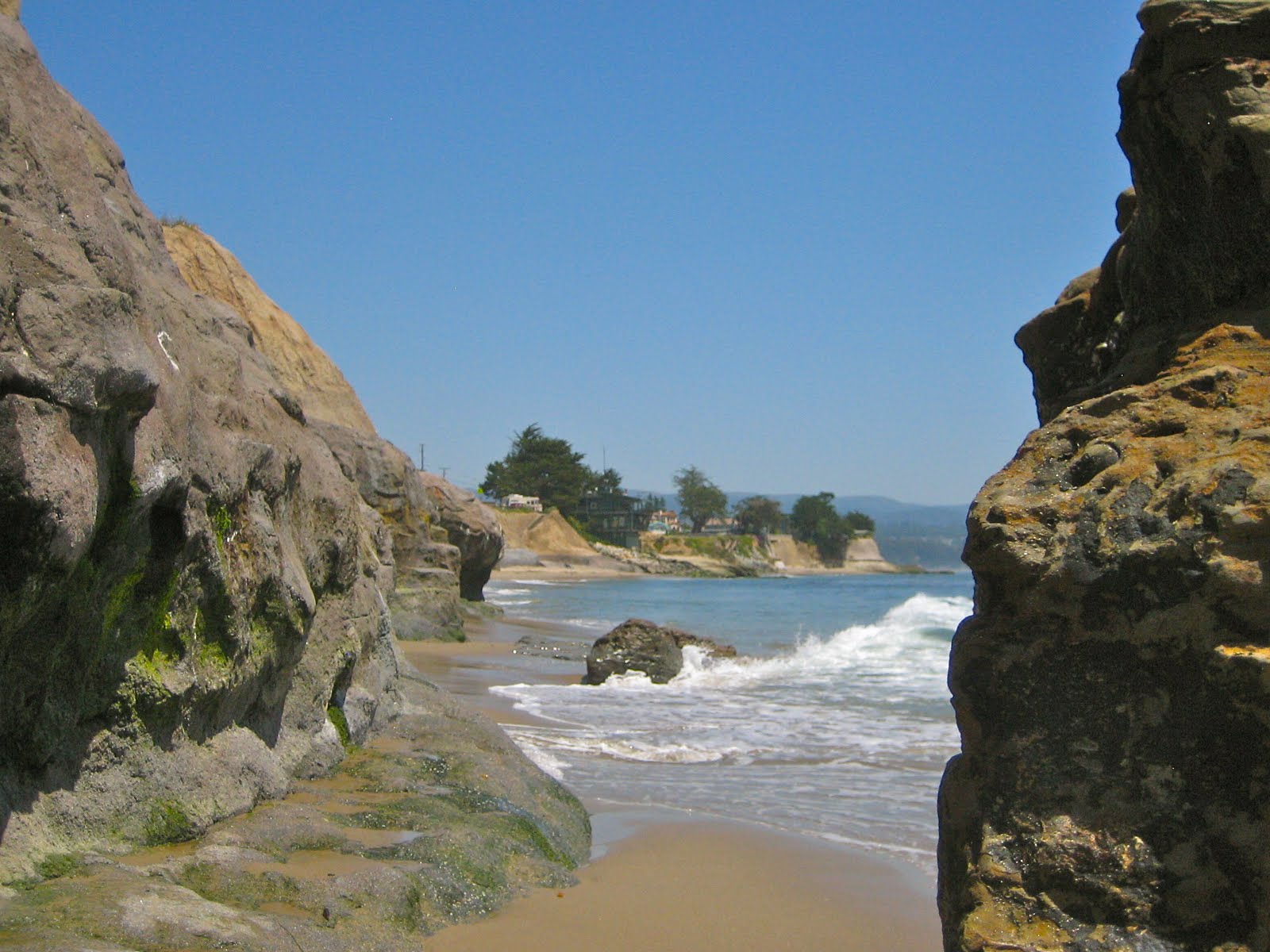
The Fishbowl, West Cliff Drive. 
Not even Mr. Sheen has a life as grand as this.  This is our week of waiting, and the weather is just glorious.  I was able to get out early the past few mornings to enjoy the sunrise and a paddle in the ocean.  Sure, there were a few waves, and some surfing involved, but it has really been just about the beautiful mornings.  Today is hot in Santa Cruz.  At least hot for Santa Cruz, with a toasty 87F at the downtown farmers's market (more on the market below) at 3PM.  I imagine that is about the peak of it with our usual afternoon cooling beginning soon, and cooler days ahead.  Tomorrow should still be almost as warm as today, and nothing is too dismal looking in the week ahead.

Thursday is still grand.  Friday morning, we again have a chance for some fog.  It will be more likely in the city and Half Moon Bay, with a chance down here in Santa Cruz.  It should burn relatively early, and doubt we will see more than a few patches, and nothing much reaching over the mountains.  Perhaps some lingering around the low areas near the bay.  We also see some actual sporadic clouds forming late Thursday from the storm system hitting to our north.  On the coast, this pattern should return to mostly sunny by Sunday morning and into next week.  Sunday still looks like the cool day, with air filtering in starting Friday.  There is a very slight of showers in the Santa Cruz Mountains, the Sierra, and from Mendocino north.  The shower threat lingers through Tuesday in the Sierra.  A rebound is expected starting Monday, with more warm days through at least mid week.  After that we will need to watch how the next short wave sets up to our north.  We need to understand that we still have a chance for rain this season.

Did I mention the Bloom! Forget Me Nots in Big Basin.
There has not been much of an overnight freeze the past few nights around Tahoe, leaving the snow a little sticky and slushy.  There is an inversion set up around 7000 feet, so the base areas are getting a slightly better freeze, as well as the higher elevations above 9000 feet.  So if you are thinking about getting out and doing some touring, try the mid to low elevations very early (around day break) or go for some of the higher peaks in the eastern Sierra.  The volcanos, Shasta and Lassen, are also looking very good, but have some longer approaches due to snow covered roads.  Squaw is turning the bull wheels daily, and Alpine is on the weekends, so there is still plenty of lift served.  Mammoth will continue to spin until the Forth of July.  Kirkwood will reopen for Memorial Day, and expects to allow skiing and hiking on the Forth again this year.  It has been a solid season.

But let us discuss a bit more of this spring.  The mid week Santa Cruz market is going off.  Some of the new additions this week are hothoused tomatoes and the season's first peaches.  We have not yet taste tested the tomatoes, but the peach was surprisingly sweet for so early in the year.  We were shocked to find some California apples that were pulled out of cold storage and still had a crisp tart of fall.  As a side note, New Leaf Market on the west side also has some amazing Fujis as of late.  Other spring notables that have been around recently are peas and zucchini.  And I am sure I have talked about the strawberries.  Well, they are certainly hitting their stride right now and are super sweet.  As much as I hate the term "Nature's candy," they are Nature's candy.  Asparagus is still around, and if you like that grassy treat, get them while they are still around.  Once it is gone, it is gone.  And there is really no point in eating asparagus unless it is freshly cut within a few days.  That is like eating a Maine lobster somewhere other than Maine. The silly thing people do.

Even the sand dunes at Moss Landing have spectacular flowers.
My fava bean harvest started a few days ago.  We have picked about 12 pods so far.  No all that much, but the plants are full of beans with just a few weeks to go.  I would say this was a successful endeavor.  I will need to go back and check my records for the exact timing, but we planted in the late fall.  The hardest part will be shucking these things, but luckily I have guest coming into town who are perfect for that job.  Back in the fall, I soaked a bunch of beans in cool water for 24 hours, then planted them about 1" deep and a few inches apart.  My rows I think were a bit close at about eight inches - I could have used a foot or more of space.  Sure, I watered the plot a bit in the beginning to get the seeds to germinate, but once winter turned on in November, I never bothered watering until mid January.  Even then, they did not get too much water.  I did need to create some supports for them, but honestly, my tomato cages would have been fine.  Recently, I started in with the water again, mostly because it has been so warm and dry.  But all in all, they did not require too much care.  I even ignored an aphid infestation at one point.  When I went to deal with it a week later, the lady bugs and other carnivore bugs had already taken care of it for me.  Simple as Fava.

Sun, sun, sun.  Today was winning.  Tomorrow, not as much.  Some fog and clouds for Friday and the weekend.  Coolest on Sunday.  Say, about 65 degrees.  Warmer again next week.  Glorious.

Tuesday, May 3, 2011

And Not Even a Touch of Fog. Simply Fantastic.

Same rock, different day.  Pleasure Point, Santa Cruz.
Santa Cruz never saw the forecasted fog the past two mornings, so I fully expect the same for tomorrow.  It now looks like Wednesday will be the peak of the current warm spell, with high 80s in Santa Cruz, and in the South Bay.  The Central Valley will get a few hot days in the low to mid 90s.  The city will have to be happy with high 70s, or perhaps, with a little luck 80 degrees.  Still, the fog that made things a little chilly the past two days should clear out to sun.  Thursday should also be warm, but the cooling begins.  Highs in the 60s are expected across the region by Sunday.  Rebound begins on Monday with the mid 70s returning to Santa Cruz.

Our cooling this weekend comes from another low pressure system running into the Pacific Northwest and Bristish Columbia.  They have had a good share of rain up there recently, with few breaks.  We should not get anything more than a few passing clouds, but Humboldt and areas north will get more rain this weekend.  Early next week, the storm track lifts north for a few days, with Vancouver on its southern flank.  Some long term forecasting are suggesting that late next week and into the following weekend, a cool pocket will begin driving south along the coast.  Moisture will build just to our west, with the possibility of a wave or two of storms hitting us around mid month.  It is not out of the ordinary to get some rain and cold in May, so we will need to keep an eye on this one.  But when compared to last year, this month is already looking great.

Bridge washed away on Eucalyptus Trail.
Up in the Sierra, the snowpack is still thick up above 8000 feet, with a fair amount of coverage down to 6000 feet.  But that should change over the next few weeks.  With day time highs in the 50s and 60s at 8000 feet this week we should see two things happen.  First, the melt off will begin in ernest.  With daily warming and early May sunshine, a lot of settlement is expected.  As a note, keep an eye on creeks, streams and rivers - both above and below snow level.  Up in the snow, use caution when approaching snow bridges.  They can collapse under the weight of a skier or sled, and underneath, the water is very cold and moving swiftly (especially in the afternoon).  Below snow level, expect water ways to rise quickly in the late afternoon and early evening.  This water will also be cold, and swift enough to sweep people and objects away.  On the plus side, there should be some killer kayaking and rafting this week, and no major flooding is expected at this point.  Secondly, in the right spots, the corn should be epic this week.  Keep an eye out for inversions, and find locations that had a good overnight freeze for the best riding.  Have fun out there on this amazing spring snow pack.  And play smart and safe.

The Wilder Ranch locals are a tough crew.
Down here on the coast, we have some great weather.  The surf is pretty small, so you may be looking for something else to do.  To beat the heat, take a walk around some redwoods.  Head up to Henry Cowell in Felton, the Pogonip by campus or Nisene Marks in Aptos.  All have great forested hiking trails.  Or you can take the bike out for a spin.  Wilder is riding well, with the forested trails much smoother than the meadow trails.  Except for some isolated, but significant storm damage, the woods are swift.  If you don't like rain pivoted single track, I suggest staying away from those in the grassy zones.  There are not a whole lot of tire ruts, but the rain did do some damage to the trails.  It looks like the rangers have already been out to work things over a bit.  And it is drying out, so some of those bumps might just get worked out by bike tires and mother nature.  Regardless, it is beautiful up there right now, and the locals are loving the spring.

Good times ahead.  Mid week to be stellar, if not a bit hot.  Some cooling Friday through Sunday, but not cold.  More warming next week, followed by a chance for a cold blast and even some rain by mid month.  The real good news, is we still don't see any signs of a significant marine layer building in the area.  Enjoy that while it lasts.  June Gloom got its name from some where.

Sunday, May 1, 2011

A Few Windy Mornings was All it Took to Get Epic.

Kids with kites making the best of a windy day.
Today was nice, so I hope you got out and grabbed a piece of it.  But we had to work for it.  Some significant wind started to blow early last Thursday and did not let up until late morning on Saturday.  The breeze brought with it some cooler air, and a few very chilly mornings.  But this was not just your typical afternoon onshore winds.  Once it started, it kept blowing, and was strongest in the early morning hours.  Conditions were prime for full days of kite boarding.  We instead opted for a nice hike up from Waddell Creek into Big Basin.  If you have never been, put this one on your tick list.  You can bike, walk or stroll the six miles through wetlands, meadows, hardwoods, redwoods, and finally up to a waterfall.  Not too shabby.

Surf outlook for the coming week is a bit bleak.  While it will not be completely flat, it is sure going to try to get close.  Through the first half of the week some small 13 period swell will be filling in form the south, offering up to waist high waves.  More likely it will be only about knee high.  It looks like the wind swell should peak around Wednesday morning.  This will actually be coming from a small gale that formed in the Gulf of Alaska today, as opposed to local gradients.  The period should be around 10 seconds, and we will get some wrap into town.  You may not need to worry about wrap, if the winds got light as forecasted.  Mornings on the open coast should be an option.  If we are lucky, we could see some head high surf at the more exposed breaks.  There is also a pretty good fetch setting up just south of the Aleutians.  If this gale holds together, we may see some medium ground swell coming from the north west by next weekend.  It may not be much, but at least it is interesting for this time of year.

Rockview looking like Palm View.
High and dry is the best way to describe the weather right now.  The winds from last week really dried the air out, leaving us with great clear conditions for the weekend.  A warm up that began yesterday will continue through this entire week.  Today things got pretty warm, and up in Felton it easily breached the 80 degree mark.  It was a nice day to sit amongst the redwoods.  The rest of the week looks grand as well.  A short fog event may start tonight.  If it does occur, it will really just be in the mornings, and on the coast.  But it will keep the heat from fully developing.  By Wednesday, the mornings should be clear again, and Thursday should see a peak in the warmth.  Look for mid 80s in Santa Cruz and Oakland.  Areas of the South Bay and Gilroy could break 90.  San Francisco and Marin should be in the high 70s (sorry city folks).  Cooling for Friday and the weekend, as the storm track begins to hit the PNW again, driving cold air south.  We are expecting mid 60s by Sunday.  Another chance for warming returns around the 11th.

Not completely flat in Santa Cruz.
Of course, we are in good gardening weather.  And it is May.  So you should be well into working your summer garden.  By now you should at least have your soil worked and amended as needed.  If you have your tomatoes in, that is great.  While we do have a nice long growing season here on the central coast, you want to make sure your summer plants have a chance to mature by our warmest months of August and September.  Plant too late, and you will see significantly fewer tomatoes and cucumbers to harvest.  So get your plants into the ground this month, if you have not done so already.  Of course, if you get a late start, you can always buy seedlings instead of seeds (this will save you from 2-6 weeks depending on plant type), or you can even buy an adolescent plant.  But the important thing to remember is water.  As the rain stops, and the air dries out, the soil will need irrigation.  Keep that soil moist, especially when you plants are young, and their root system small.  Fava Beans are in full harvest right now.  Peas are starting to show as well.  Things are really starting to roll.

A nice week ahead.  Perhaps a touch of fog, but nothing like last summer.  Of course it is still a bit early for us to see too much grey, but not out of the question.  By Tuesday afternoon we look like clear and warming with some spectacular weather on Wednesday and Thursday.  Cooler, but still great outdoor weather for the weekend.