Saturday, December 31, 2011

New Years Eve Report.

Winter blooms near the Santa Cruz Municipal Wharf.
Happy New Years everyone.  2011 ends under clear skies.  Great for any fireworks displays you may want to attend.  They will be firing off the lights tonight at Kirkwood around 7pm, after a torch light parade down one steep and icy man made groomer.  This year started off very wet, and we saw winter last through early June.  Spring never really came around.  Summer wore off a little early, but fall stuck around through the end of its calendar run.  2012 looks to start off with some fall like weather.  We did see some flurries last evening at elevation.  It was nice, at least, to see some snow fall from the sky, even if it did not accumulate.


Plan for another week or two of fall like weather.  That is great for those of us down on the coast.  Mid 60s and sun will be the name of the game.  But don't go thinking we won't have a winter.  Even a bad year in these parts equates to 200 plus inches of snow and we have only see 30 so far.  So rain and snow is in our future as we swing into the new year.  Good chance we see the wet season start in two weeks, and when it does, we could see several weeks of wet weather.  Good money is on a wet February, with things drying out a bit by mid March.  Spring could come early, but know that winter will come.  In the meantime, go walk the beach.  It is awesome out there.

Friday, December 30, 2011

Brief chance for rain tonight. Warming trend on tap.

Winter is often the best time of year here in Santa Cruz County.  The heavy seemingly permanent marine layer is gone, and if we are under a ridge, the days can be quite pleasant.  Toasty even.  That is the pattern we are in now.  Sure, this is not great for snow lovers or for an epic water year, but it does make for some nice beach strolling weather.  It is also helpful to our winter gardens, and often results in good surf.  And we have all of that right now.  Except for a brief chance of rain north of San Francisco tonight, plan for clear skies and increasing daytime highs (as well as a bump in the over night lows).

Draft horses at Wilder Ranch, Santa Cruz.

A storm moving into the PNW today will drag a little bit of moisture through the northern portion of our state tonight.  The Sierra may see some flurries, but not enough to really measure.  In Santa Cruz, we may see some morning fog, but expect that to clear quickly.  A great weekend is again on tap.  Highs along the coast will push into the high 60s.  Our overnight lows will be in the high 30s and low 40s.  Not too shabby for the last days of 2011.  And 2012 will start out even better, with highs pushing 70F the early part of next week.  The peak of the trend looks to be around Tuesday.  With all this great weather on tap, it may be hard to recall that we are in the midst of our rainy season.  Do not fret.  It is on the way.

More birds enjoying the low tide reefs.

Models are starting to pick up on a pattern change.  Teleconnections support the change as well.  For the past month plus, we have been a ridge set up over the west coast, forcing storms to our north and south.  This has been great for sunny days, but if you have been up to Tahoe recently, you may have noticed we are having the driest December on record.  Not really any snow up there in the mountains.  With some luck, that will soon change.  We are still too far out to talk about much in the terms of specifics, but it does look like rain will soon be upon us.  Plan for a change to start as early as late next week, more more likely around the 10th of the month.  If a large scale trough does set up, plan for a week or two of mostly wet weather.  In other words, get out there and enjoy the great New Years.  Happy New Years.

Monday, December 26, 2011

Rain and Snow likely..... for the Pacific Northwest.

Another run of the models and forecast suggest that the majority of this week's storms will stay well north of the Bay Area.  So what does that mean for us?  For one, this may become the driest December in history for much of the state.  What a change from last year, when we were getting hammered with 100" weeks of snow.  After last winter, it will take more than a single record dry month to knock us back into the world of drought, but it is something to think about.  We may be headed right back were we came from.  That being said, let us take a look at the coming week.


Sea birds feast along the reefs at low tide on the open north coast of Santa Cruz County.

Today should again be a beautiful day.  Expect high 50s to about 60 along the coast.  And the morning's are getting a bit less cold.  Things begin to change on Tuesday, as a storm system moves through the region, mostly to our north.  The southerly trailing edge of the system may bring rain to areas north of San Francisco, especially in the evening hours.  The byproduct of this wave could be fog for us folks living in the city on south.  As for the folks in the central valley, they could see their cold inversion fog cleared out, at least for a few days.  Rain, or showers, could persist through the day on Wednesday.  Yet again, this is pretty much only likely north of SF.  For those of us to the south, we should see the fog clear and partly sunny skies for Wednesday and the rest of the week.  Another system drags by to our north on Friday.

Sun and waves.  Somewhere along West Cliff Drive.

All in all, we look to stay dry this week, south of the city.  Points north could see some showery weather Tuesday night into Wednesday, and again during the day on Friday.  But really, just a slight chance.  Tahoe is likely going to miss all this action, but there is a chance of a dusting to a few inches of snow.  Nothing at all to get excited about, and not enough to turn the season on.  As for a bit of weather detail in the Sierra, expect around 45-50F at 7000 feet.  It should be nice weather for schussing the manmade snow, climbing rock walls or hitting up the mountain bike trails.  Down here on the coast, waves continue through the first half of this week, with more possibly on the way.  And of course, the weather is quite nice for hitting up the links.

Sunday, December 25, 2011

Cold for now. Maybe rain for later.

Farm building at Wilder Ranch, Santa Cruz.
Merry Christmas.  Another cold morning on tap out there today.  A hard freeze in the central valley and a soft, or short, freeze her along the coast.  Regardless, it is very cold out there in the morning right now.  After today,things get a bit milder at night.  The good news is that today will be quite warm for late December.  Mid 60s down here on the coast with plenty of sun.  As we move through this coming week, we will see the over night lows rise to near 40, and the day time high drop back down to just about 60.  In other words, it will continue to be beautiful winter weather.  Or will it?  Chances for rain are on the increase this week.

Sunday and Monday are going to be spectacular and clear.  Tuesday will also start out that way.  But as we move through mid day and into the evening, we should see some clouds beginning to tarnish our skies.  Right now there is about a 50% chance of showers for the day on Wednesday.  We will get this fine tuned as we get a little closer.  Basically, what is starting to happen, is we are seeing our ever lasting ridges beginning to break down and shift off to our south and east.  This is not yet a open storm door pattern, but it may trend that way in the coming weeks.  Another chance for rain occurs on Thursday and again about Saturday, but it looks less likely than even Wednesday.  With all of these systems, the bulk of the weather is to remain north of us.  Of course, that means the PNW is expecting to get hammered.  

It does look like a pattern change is approaching.  I know I have said this before, but to be honest, this season has been a bit challenging.  Still, we are looking at the possibility of a large scale trough moving toward us in the first week after the new year.  By about the 10th, we could find ourselves in a wet pattern.  So, the best advice I have is to get out over the holidays and enjoy the best that our region has to offer.  And just in case you have not noticed, the surf has been, and will continue to be, quite good.  This is the kind of pattern that we love down here on the coast.  Today is fun sized, but another swell fills in on Monday, knocking it back up to pucker sized.  If you don't surf, then get on the bike.  Or go for a hike. Or tend to the garden.  It is a great time of year to get out and play.

Moss Landing Power Plant and Harbor, Santa Cruz County.  Another great day to be on the water.

Snow is still pretty bare up in the Sierra, and the possibility of snow on Wednesday will not make much of a difference.  The good news is that snow levels will be pretty high.  The bad news is that they may be too high.  It would be a bit of a disappointment if the first precipitation we have had in weeks comes as rain in the high country.  Right now we are looking at the chance of a few to maybe six inches of wet snow above 7000 feet.  Why is wet snow a good thing?  Well, what we need right now is a base and the wetter, the better.  It sticks to everything and barely compresses.  Cross the fingers and pray for snow.  We need it.

Great day today.  And another tomorrow.  Tuesday starts nice, and then a chance of rain by Wednesday and into Thursday.  Fair for Friday and possibly a little more rain next weekend.  More to come.  Merry Christmas and happy holidays.

Friday, December 23, 2011

Will She, or Won't She.

She being Mother Nature, and us asking about the rain.  While the teleconnections are not in favor of a big change in the weather, we are starting to see some change in the models.  Both the Euro and the Japanese are fairly progressive, but the American models keep us fairly dry for some time to come.  More on that later.  For now, let us look at the upcoming weekend.  And it will be nice out there if you don't mind some crispy cold in the early morning hours.  But from 11am to 1pm, it actually feels like you could sport a pair of shorts.

Great sailing weather off of Lighthouse Point, in Monterey Bay.
Today through Tuesday look fairly text book for late December, as we officially move into winter.  Mornings will be cold.  As in freezing cold.  The immediate coast will see low 30s as the sun comes up.  Put on a puffy and go out an enjoy the awesomeness that is a winter sunrise in Santa Cruz.  The sky will be clear, except for the chance of a few clouds.  Things warm up slowly, but peak at about 60.  Like I said, it feels darn good out there around the noon hour.  With the sun low, it gets cold quickly this time of year.  So don't delay.

Lighthouse Point, Santa Cruz.  The northern tip of Monterey Bay.

I will update later today or tomorrow, but we are seeing a chance of light rain as early as next Wednesday.  This may change a bit of what you can read in the Holiday Ski Forecast at Powder Happy. I'll will post an update to that as well.  As a teaser, Northstar is riding very nicely.  Just avoid the Vista lift mid day and the crowds are not too bad either.  More soon.  Enjoy a perfect winter weekend.

Oh, and for those of you driving through the central valley, we still have that inversion and thick fog.  Don't be the guy bobbing and weaving with zero visibility, just to save 5 minutes.  With the cold, we could even see some ice develop in the early morning hours.  Be safe, and considerate.

Saturday, December 17, 2011

Gripped. Same ole, same ole.

Cypress and sunset viewing seats along West Cliff.
The eastern Pacific is currently gripped under a very persistent high pressure ridge.  There is all kind of talk in the weather geek blogosphere about dying MJO, stratospheric warming, AO dipping and the such.  It is basically a war of the indicators and forecasting tools.  In the end, we still have this bubble sitting on top of us and pushing any inclement weather well to the north.  And when a weakens is found in the armor, and a system is aloud to push south, it has split apart every time in the last six weeks.  We have yet to see a real storm hit central California since early October.  So, this is good news if you don't snow sport.  Bad news if you do.

The weather continues as it has been.  Cool to cold mornings.  Not quite freezing on the coast, but that is like splitting hairs.  I am sure if you are an early morning commuter, you have bought an ice scraper by now.  Or at least destroyed a number of CD gem cases (do those still exist?)  Freezing temperatures are happening in the central valley and the southern San Joaquin.  This is hard freeze weather.  It is not a bad idea to have some floating row covers out there is you have any less than hardy plants, including seedlings.  Tuesday morning looks to be the coldest one  this coming week.  Day time highs are reaching to the high 50s and (very) low 60s across the region.  It is the kind of weather that is warm in the sun and cool in the shade.  I can attest that changing out of a wetsuit after sunset is a cold experience indeed.  Expect this weather at least for the next week.  We did see a small system forecast for next Thursday, but that has disappeared from the models.  In fact, we currently see high and dry through the end of the month.

Empty waves on the north coast, Santa Cruz County.

For those who live in the central valley, or those who travel through them, thick heavy fog will be the name of the game in the morning hours.  This fog can persist all day in areas.  This is typical of this winter like pattern.  An inversion sets up, where cold air pools and gets trapped along the valley floor, while warm air, which is lighter, floats on top.  The border between to the forms fog that can last until the next storm brings winds that sweep out the valley.  So use caution, drive carefully, and plan for extra driving time.  This goes for the holiday season as well, as it looks like we will not see a storm on the front side of the period.

Surf is starting up again today.  In fact, it never quite went away this week.  Nothing like last weekend surf, which got quite good.  SOme might have called it epic.  Still, we have a new swell in the water today, showing a little overhead and with clean conditions.  Another larger swell arrives some time Sunday, with clean morning conditions.  It looks like storms keep on rolling off of Asia into the NW Pacific before getting bumped north and shut down by the blocking high in the Gulf of Alaska and along the west coast.  While this is not great fro giving us rain and snow, it is  pretty ideal set up for surf.  While we won't be getting a Maverick's swell from this pattern, we can get plenty of clean, decent sized days.

Looking south to the Monterey Peninsula, from West Cliff Drive.

So in short, get out there and enjoy the weather.  It is that kind of pattern.  Not hot by any means.  Barely warm.  Still, it is nearly perfect for any activity that gets the heart rate up.  And soon enough, it will be rainy, and you don't want to think then that you should have enjoyed outdoor California back in December when you were busy shopping at the mall.  Lows in the high 30s, highs almost to 60F, and clear skies.

Tuesday, December 13, 2011

More fair days ahead. Rain seems unlikely.

Scenic Highway 1.  Scotts Creek Bridge.
The clouds have cleared after a cool and damp day on Monday.  We had a decent drizzle overnight Sunday here in Santa Cruz.  Still, not really enough water to talk much about.  Just enough to reconstitute the ground.  Sun is the name of the game moving through the next few days.  Expect highs to be around 60F and lows in the upper 30s.  Light winds as well.  All in all, quite nice out there.  We still have a system to watch for this coming Thursday, but as we get closer it looks like there is some agreement on the storm remaining mostly to our north, with perhaps the lowest portion of the through moving through our region.  Most of the energy moves east of the region well north of us.  And it is not particularly impressive as it is.  Just a small, compact and swift low.

Through the week, temperatures stay about the same.  Showers, if they do come, will fill in on Thursday and be mostly to our east by evening.  Some areas could see drizzle linger overnight.  But unless there is a course change in the next 48 hours, precipitation will be light and brief.  Things clear out pretty quickly and we see a good amount of sun on Friday.  The weekend looks like another great one for outdoor adventure. Crisp, cool (okay, maybe more like cold) and clear mornings that warm quickly in the sun.  Highs just about 60 down here on the coast.  And it looks like we may get another solid swell for Sunday.  Mostly utility stuff before that and through this week.

Now, that is not good news for the snow.  At least we have some cold temps on tap, so those who wish to, can blow some snow.  Northstar keeps topping the list, and now has the backside open.  Long runs with good surface conditions.  Kirkwood has two runs off Chair 5 going, and reports are coming back very good.  They are shutting the lift down for an hour to do a noon groom.  And they have cheap lift tickets and $2 IPAs.  Looks like they will be getting a run off Chair 11 open soon.  Oh, and they are running weekends only right now.  Heavenly gets a third place with much more terrain open than Kirkwood, but the crowds keeps the runs well scraped after the early morning.  Other resorts are up and running on limited terrain, and it looks to remain so for the near term.  This week, they hope for even a few inches of the real stuff to supplement the slopes.  I'll put up a holiday ski report later this week, with a long term forecast or guesscast.

Entering the bay and returning home at sunset.  West Cliff Drive, Santa Cruz.

For now smooth sailing.  So get out and enjoy the best that fall has to offer here on the Central Coast.  If you do not love to hike, bike, surf or other active sweaty type thing.  And you just want to avoid the yard work, then think of something to do to enjoy the weather.  Great weekend for a drive around a valley sipping different wines.  For instance.

Sunday, December 11, 2011

The eradictae and unpredictable nature of a cut off.

The coast north of Santa Cruz is riddled with beautiful beaches.
We've talked about this.  When storms cut off from the jet stream, and close up, they travel around in an eradicate manner.  There track is not completely random, but is effected by out side forces.  For instance, they rarely break through a high pressure.  They will take the path of least resistance.  But they are hard to forecast in regard to their exact track.  The one now working its way south just west of the California coast is a good example.  It is also a weak system, that will slowly be shut down over the next 48 hours.  Very little of this storm will survive to push east under the high pressure settled over us.  Still, friends to our south and into Arizona will likely get a decent rain storm from this one tomorrow and Tuesday.

That being said, clouds are the name of the game today and tonight.  We do see a very slight chance for rain overnight tonight.  Greatest chances are for showers after midnight and before sunrise on Monday.  Almost like it never even really happens.  But the roads could be slick.  It has been several weeks since the last rain, so there is some oil build up out there.  Nothing like the first rains of the season, but still, give some room tomorrow morning.  Then, after clearing by Monday afternoon, the first half of the week looks nice.  Expect what we have been getting.  About 60F at day and high 30s at night.

The system for Thursday seems to be on track, but the bullseye is well north of our area.  Timing looks like it will be an evening or overnight event.  And this system is both compact, and quick moving.  A bunch can change between no and then, but most of the precipitation will be falling north of San Francisco, with a weak wave moving through early Friday and pushing south toward Big Sur.  Northern California and Oregon could get a fare amount of rain.  Nearly an inch in areas.  Monterey currently looks like a tenth of an inch or less.  Of course, the path of this storm could shift south over the next few days and things could change.

Decent swells last through the early part of next week.  Four Mile Beach at sunset.

For you snow loving folks, this is not the storm we are looking for.  We need a hammering up there.  We need several feet to get things started and the resorts open.  It may not be a white Christmas after all.  But, of course, we still have time.  That being said, every little inch counts this time of year.  So we will watch this one closely.  Remember how the Thanksgiving storm never materialized, but even the Monday forecast that week had us expecting multiple feet of snow?  Things can always go the other way.  So wash your cars, burn some skis or do a dance.  But of course, if the snow does not come, that usually means great weather for us down here on the coast.  More on this system as the models mature and come into agreement.  We will have a much better idea of what to expect as we get closer.  For now, plan for showery weather to return to the region some time on Thursday and clearing out by the weekend.  Also watch out for wet weather late today and into tomorrow morning.

Saturday, December 10, 2011

It is Monarch season baby.

Can you count the butterflies?  Look in the shadows.  This is about 5% of them.
Not much to report on the weather this morning. Other than a great day to head out and get some (or view some) surf, things are just putting along. Continued fare weather today, with a chance of showers later on Sunday. With this morning's models, chances look very slight. Still, we should see some increase in cloud cover. That will stick around for Monday morning, before we see limited clearing. And the temperatures will rebound a bit after a cold front sweeps through Sunday, leaving things crisp. No real update yet for later next week, but everyone should be planning on some wetter weather moving into the coast well before the holidays,

But, still, I wanted to share a little secret with you. I have talked about the butterflies here before, but man, it is going off right now. I walked through Lighthouse Field (the green space on West Cliff Drive, across from Steamer Lane) and buzzed the Monarch zone. It was good. Butterflies in the ice plant. Many zipping back and forth. A bunch munching on the nectar of the eucalyptus trees. But the motherlode were nestled, out of the wind, along some euc and pines. Thousands. Tens of thousands. It takes a moment to see them. Partially because there are so many. And partially because they look like hanging leaves. I can't wait to go back on a gusty day, and wait for the wind to blow. The sky will be an explosian of orange and blue. So if you are sitting at home on this fine Saturday, wasting away indoors. Don't. Come on out to Lighthouse Field and enjoy some nature. And the bonus is, everyone is down at Natural Bridges, so the crowds are minimal.

Monarch season.

The good news, as far as the weather goes, is that any rain tomorrow should be a boating issue in central California.  The weak storm system that is moving south over night is going to stay well off shore until around Point Conception.  The southern end of the state is still expecting some rain on Monday.  We will still see a cooler day tomorrow, but overall quite nice.  Get out there and enjoy the rest of the weekend.

Friday, December 9, 2011

More rain for SoCal. Pattern starting to change.

Scotts Creek Beach.  The north coast is a great place to stroll.
The ridge we are currently enjoying, will begin to shift to the east over this coming weekend.  Another is forming in the Pacific, and will soon replace it.  But this movement is just enough to allow a cut off low to form and move south.  This thing is nothing impressive, but will slowly move down the coast on Sunday.  Chance of showery weather in our area, with more rain looking likely for Los Angeles.  It has been a wet year for them down south.  As much rain (just short of three inches) has fallen down south as around these parts since July.  While we are starting off this season dryer than normal, they are looking wetter.  Go figure.  But things are going to change around here.  Timing is the big question.

Saturday is looking pretty nice, with calm winds, decent surf and mild temperatures (60ish).  The above mentioned storm begins to move down the coast on Sunday, bringing with it some colder air, a chance of showers, and with some luck, a dusting of snow up high.  You'll at least want a sweater for Sunday, with highs in the low 50s down here on the coast.  Rain is not likely, but we do see a possibility of this system moving close enough to shore to give us some showers.  A ridge moves back in on Monday, bringing with it some windier north west flow.  But at least we see a little bit of warming.  Mild conditions continue through mid week, when we see a chance of more storminess.

A chance.  None of this is set in stone.  In fact, the track of the late weekend system is far from set.  As with all cut off lows, this thing will have a mind of its own.  For next week, things start to get interesting around Thursday.  As the replacement high also begins to move toward the east, the storm door will be left ajar.  This is not an open storm door situation, and deep troughs along the California coast are not expected.  Still, we could see a system droop far enough south to give us some much needed moisture.  We will keep an eye on this, and continue to pray for snow at the Tahoe resorts.  If things do come to pass, we could expect inclement weather starting some time around the 15th, building through the 18th and then lingering until the 22nd.  100 percent speculative fiction there, but we'll take another look at the models over the next few days and see how the resolve the issue.

And West Cliff Drive is a great place to catch a sunset.

In the meantime, get out and enjoy a great Saturday.  Sunday could also turn out well, but carry a shell.  Showers could develop in the afternoon.  Chances increase as you travel south.  Rain looks likely Sunday night and Monday for SoCal.  By Monday afternoon, we see some clearing, but more clouds than this past week.  Look for a pattern change to happen by late next week.  In other words, get prepared for some rain and handle outdoor activities this weekend.

Wednesday, December 7, 2011

Continued dry and cool. Moderate swell and Spectacular weather for the weekend.

Frosty mornings here in Santa Cruz.
Okay.  Probably depends on what your idea of spectacular is.  It is not going to be 90F out there.  More like topping out at 60F.  But with little wind, and mostly sunny skies, so great days for outdoor activities are coming this weekend.  But you do not need to wait, as this entire week looks pretty darn nice.  Cold weather again this morning along the coast, and a freeze in the interior.  Things should moderate a bit through the week, but we don't see any significant warming of the overnight lows.  Clear skies keep the radiative cooling at a maximum.  The past few mornings required early morning drivers to use an ice scraper to clear the windshield.  If you don't have one in your car, go out and get one.  Frosty windows are driving hazards.  Don't be that guy.


Word around town is that the bike trails are riding epically.  Rains in the previous month has settled all the dust and provided a tacky surface to rail turns on.  And the summer crowds are gone.  Wilder is like a ghost town, with miles of trails to ones self.  Even the weekends are coming back with reports of uncrowded conditions.  If you prefer to be in the ocean, the swell coming for this weekend is in the water.  The storm did not hold together quite as well as hoped, but we should still be expecting a moderate long period swell to arrive sometime Friday.  It will start off small, but build quickly by Saturday morning.  Plan for some ten foot surf at the better exposed NW breaks through the weekend.  And some great conditions all day Saturday and through the morning Sunday.

Surf should improve along West Cliff Drive this coming weekend.  John Street sunset dribbles.

Still no big weather changers in the forecast.  In fact, major indicators suggest more of the same.  Sure, there is an outside chance of energy approaching the coast.  Even a chance of splitting.  But that means, even in the best scenarios, we see a 50/50 chance of sporadic and light precipitation.  So, outside of an outside chance.  And no major trough is expected for the west coast, well into mid month.  So another week plus of clear, dry and beautiful weather.  And as much as I love this time of year, I do pray for a little snow before the holidays.  If not for my benefit, then for the tax base.  For now, nighttime lows 36-42F and daytime highs 55-61F.  That is all.

Monday, December 5, 2011

Omega Freeze.

Omega blocking sits high pressure on top of us, keeping things clear, dry and cool.  Cool being the operative word.  Freeze Warnings are up across the Central Valley and a Frost Advisory is posted for around the Bay Area.  Sure, San Francisco, with its concrete and asphalt will stay in the mid 40s, but else where we expect a range of high 20s (Santa Rosa and King City) to mid 30s (Santa Cruz and San Jose) early Tuesday morning.  Protect those plants.  Basically, the further you get away from the ocean or urban locations, the cooler it will be.  Especially in valleys that trap and pool the cold air.  Things moderate later in the week.


Four Mile Beach, Santa Cruz.  Nice place for a sunset stroll.


The weather basically looks cool and mellow the first half of the week.  Highs should be just about 60F in Santa Cruz.  And all the wind of the past few days has subsided.  Should be a few good mornings to hit the links (I assume).  The second half of next week sees a chance of some increased winds, but we should stay dry.  Outside chance for some showers in the Sierra.  Nothing to get excited about.  And the pattern continues.  Teleconnections now look pretty neutral, so we are looking at an extended dry period.  Yes, some models show a slight chance for moisture to run over us around the 12th, but that is (1) speculation and (2) a weak splitting storm that has no sense showing up in the models.  So plan for dry.  But it won't last, and winter will come, so don't delay and finish any fall yard work this coming week and weekend.


Surfing the coast north of Santa Cruz usually means cold and jumbled with awesome views.


So, need to mention the chance of solid swell for this coming weekend.  The storm that will send this swell is still building, so it is far from in the water.  So far, this thing is brewing as forecast, and if it continues to do so, we good see long period, as in 20 seconds plus, waves begin to impact the coast this coming Friday.  Height will not be huge with this thing, but looking respectable.  The waves will build quickly, and large waves will seemingly pop out of no where.  Use caution when approaching the ocean this coming Friday afternoon and into Saturday.  Still, this will be a great time to go out and watch the ocean.  Or get in it, if you enjoy that sort of thing.

Friday, December 2, 2011

High and dry for the mid term. Nice Friday and Saturday on tap.

Water is running, and the foliage still has color.  Go for a hike.
High pressure has filled in nicely over the region.  Strong winds started to subside in the very early morning hours Friday.  There is still an ongoing wind event, and we may see a bump back up in velocity for Saturday, but today is looking very nice.  A few lucky folks in the right sun exposed and wind protected areas around the Bay will likely see 70F today.   And that is about 5 ot more degrees warmer than what is expected in Los Angeles today.  For reals.  Welcome to December on the central Cali coast.  Gotta love this place.  Oh, btw, Santa Cruz is one of those spots.  And that is about 5 ot more degrees warmer than what is expected in Los Angeles today.


That is not to say it won't be cold out there.  The interior valleys near SLO are looking at a Freeze Watch, and the San Joaquin is still under a Frost Advisory.  The Santa Cruz Mountains may see brief periods of below 32 temps both early Saturday and Sunday mornings.  Santa Cruz will dip into the high 30s.  I wouldn't expect to see low temps much above 42F the next few day around the Bay, expect in the most paved, concreted and urban areas (Hello, toasty Market Street).  As we move through the weekend and into next week, things moderate a bit.  The night time warms up a touch, and the days cool to around 55 in the city, 60 or a touch warmer in the in Santa Cruz and Los Gatos.  All in all a great weekend to get outside and enjoy what December has to offer us.

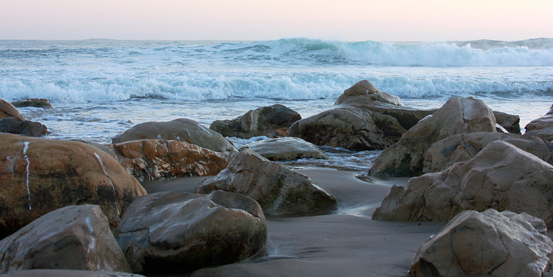
Surf is on tap, with re-enforcements moving into tonight.  Decent to good conditions through the weekend.  Especially in the morning.  Great conditions all day for mountain biking and jogging.  Over heating will not be a big concern.  I bet West Cliff will be busy by late morning, so get out there early if you like a little solitude.  Sunrises have been pretty nice recently, with just enough cloud cover on the horizon to make it interesting.  I've been watching them from the house, but I know it is worth getting out there early if you can pull it off.  Hiking should be top notch this weekend.  Last week's rain has allowed the brooks to get rolling again.  Waterfalls will be minimal, but better than nothing.  Big Basin and Big Sur both have spectacular short hikes worth looking into.  And if none of that appeals to you, then get some yard work done.  This is a great time to be planting some winter seedlings, like lettuce, as the next few weeks look sunny and mild.

Even after the sun sets, there is still good light in the sky.  Go enjoy the outdoors.

Basically, we should continue as is through around the tenth of the Month.  Or further.  Sure, there are some teleconnection forecasts that suggest a shift.  But this is like a forecast or an indicator that suggest the high will retrograde, and if lows are present, they may slip down our coast, and not split, and then, just maybe we will get some rain and snow.  But in the meantime, is sure looks like it will be dry.  Got a roofing job to start?  Get on it Monday.  For those of you looking for snow, those resorts with the best snowmaking, and the best effort, will make the most of it.  Word is Northstar is the place to be right now.  Heavenly is a close second.  And while super limited, I'd suggest KW for third.  They at least have a little real snow off to the sides, if you don't mind hitting a few twigs.  But until Mother Nature delivers, the season is essentially on hold.

In short, great fall weather is on tap for the next week or two.  There is indication of a change of pattern after that, but we will need to wait and see what happens.  I'd be willing to bet we make it past the 15th before we have any real rain.  Check back in often, as things can change quite.  And it the weather remains boring and nice, I'll be sure to put up some content in the Market and Garden Report.  For now, enjoy the great weather.