 |
| More swan. |
Wednesday, April 30, 2014
Stunning.
What an absolutely gorgeous day. Upper 80s in town. Low 80s at the beach. Who knows how hot it got in the Costco parking lot. Stunning sunset. It even felt warm changing road side at dusk. Surf is super clean and there is a fun combo swell running. Some beaches are packed, but we had our own stretch of coast today, with just the occasional surfer strolling by on there way to some hidden ledge. I feel so lucky to live here on these sort of days. Thursday will be another one. No real change in the forecast, with Friday back down into the lower 80s. The weekend we will normalize with highs hovering around 70F. Maybe a touch cooler as the sea breeze begins to pick back up in the afternoons. There is some model chatter of a rain system trying to reach into our region for early next week, but this thing is not currently looking too impressive. Say a chance for showers Tuesday. More on that later. Enjoy the weather. It is about as good as it gets.
Monday, April 28, 2014
Beach Week.
So, yeah, the next few days are going to be off the hook nice. There will still be a sea breeze tomorrow keeping it in the low 80s. Wednesday and Thursday should be in the upper 80s with very light winds. I've got to take the car in Wednesday, which is too bad, because I just want to hit the beach. They will be those kind of days. Friday will be a bit cooler, and some fog may develop on the ocean, but it will still be in the upper 70s. The weekend normalizes.
Probably some light morning fog, but no May Grey yet developing. It is still April. Highs drop back into the upper 60s, and over night lows might start to drop below 50F. Still, it won't be too cold. I'm going to work on getting our tomatoes in during this week and next. It is that time of year. Finally.
 |
| Spring Pond. |
Probably some light morning fog, but no May Grey yet developing. It is still April. Highs drop back into the upper 60s, and over night lows might start to drop below 50F. Still, it won't be too cold. I'm going to work on getting our tomatoes in during this week and next. It is that time of year. Finally.
Sunday, April 27, 2014
Ah man, is it gonna get nice out.
First off, the rain. Came in hard for an hour Friday afternoon. Now if something like that stuck around for a day, or a week, we would make real progress in fighting the drought. As it is, we made another small dent. More on that when the next report get released. Anyway, showers occurred across the region this morning, but things cleared out later in the day. The Sierra had few sporadic snow showers through the day, but mostly a little sunshine to close out Kirkwood and Squaw. I think the only game left in town is Alpine weekends. unless you fancy driving to Mammoth. They have committed to Memorial Day. If it is beach weather you want, then just stick here in town.
Monday is going to be sunny and warm. Sure, there will be a brisk afternoon sea breeze, but mid 70s are not bad. But when you compare that to Tuesday, well, it is sub par. Low 80s Tuesday. By Tuesday night, our over night lows will begin to hover in the mid 50s. You know what that means, don't ya? Tomato planting season. Upper 80s Wednesday. A few parts of town could hit 90F. No kidding. Part of what is happening is the on shore flow is stopping. Light winds for the middle of the week. Of course that kind of weather will never last in Santa Cruz. By Friday we will be back into the upper 70s, and we could see much cooler weather, on shore breezes, and fog returning for the next weekend.
 |
| Remember this guy? Swan. |
Monday is going to be sunny and warm. Sure, there will be a brisk afternoon sea breeze, but mid 70s are not bad. But when you compare that to Tuesday, well, it is sub par. Low 80s Tuesday. By Tuesday night, our over night lows will begin to hover in the mid 50s. You know what that means, don't ya? Tomato planting season. Upper 80s Wednesday. A few parts of town could hit 90F. No kidding. Part of what is happening is the on shore flow is stopping. Light winds for the middle of the week. Of course that kind of weather will never last in Santa Cruz. By Friday we will be back into the upper 70s, and we could see much cooler weather, on shore breezes, and fog returning for the next weekend.
Thursday, April 24, 2014
Yes, rain actually tomorrow.
That is all. More later, but, yes, it really does look like we will get rain tomorrow. The models still have not aligned, but rain looks like it will fill in during the very early morning hours on Friday and persist through the day. A second round will push in late Friday. GFS suggest things will dry out by Friday morning. The Canadian suggest it will rain through mid day. A quarter to an half inch depending on who you believe. An inch to an inch and a half in the mountains. A possible pulse could pass through later in the weekend. More of an update later today, but for now, plan for a wet Friday.
Wednesday, April 23, 2014
Swing Vote.
So, it looks like the GFS was the winner on Tuesday. We received a brief, light shower at our house in the very early morning hours Tuesday. Just enough to wet the surface of things. Just a bit more than the fog provides. Barely. That was pretty much what we got around the Bay Area. Boulder Creek ended up with .05 inches, and no where locally recorded a tenth of an inch. Sequel measured 0.0, and I'd imagine we would need a pretty fancy gauge to record any here. So, basically, the moisture stayed north and east. In fact, more to the east. Napa came in with a trace. The Sierra received about 6 inches of snow, or a half inch water equivalent. So, they got something. Things look real nice today and Thursday. What ever happened, the fog got pushed out. That is nice. It is cool out. The sea breeze was rocking it yesterday, and we can expect some more wind this afternoon. Thursday could hit 70F. Then chances are looking good for some actual rain.
The GFS and the Canadian forecast about the same amount of water, but with different timing and duration. About a quarter of inch locally, with one plus inches in the Sierra and northern quarter of the state. Let's start with the GFS. This morning it brings light rain to Santa Cruz and Monterey Bay for the day on Friday, clearing out late. Nothing heavy, and likely sporadic, but wet none the less. The storm is much more concentrated to the north and east, just like this last one. A foot of snow for the crest. Get you last powder day on. The Canadian, on the other hand, has the rain holding off until maybe mid day Friday, with showers filling in for Saturday morning. It also brings another light amount Sunday afternoon. Okay, so maybe the Canadian has a little more water, but ultimately, it is more prolonged, lighter showers. This scenario could drop more significant water in the hills and mountains. So, the swing vote is the Euro. I rarely look toward the old continent for guidance, but I did this morning. She agrees with her old colony. Rain Friday, clearing for the weekend. Now, I know you weekend loving folks would love to see some fair weather and sunshine. But, I have my fingers crossed for rain. And snow.
Splendid Monday and Tuesday. And for the coming week. Expect some mid to upper 70s. More on that and fine tuning the weekend, so check back.
 |
| It is spring in Santa Cruz. |
The GFS and the Canadian forecast about the same amount of water, but with different timing and duration. About a quarter of inch locally, with one plus inches in the Sierra and northern quarter of the state. Let's start with the GFS. This morning it brings light rain to Santa Cruz and Monterey Bay for the day on Friday, clearing out late. Nothing heavy, and likely sporadic, but wet none the less. The storm is much more concentrated to the north and east, just like this last one. A foot of snow for the crest. Get you last powder day on. The Canadian, on the other hand, has the rain holding off until maybe mid day Friday, with showers filling in for Saturday morning. It also brings another light amount Sunday afternoon. Okay, so maybe the Canadian has a little more water, but ultimately, it is more prolonged, lighter showers. This scenario could drop more significant water in the hills and mountains. So, the swing vote is the Euro. I rarely look toward the old continent for guidance, but I did this morning. She agrees with her old colony. Rain Friday, clearing for the weekend. Now, I know you weekend loving folks would love to see some fair weather and sunshine. But, I have my fingers crossed for rain. And snow.
Splendid Monday and Tuesday. And for the coming week. Expect some mid to upper 70s. More on that and fine tuning the weekend, so check back.
Monday, April 21, 2014
Go Canadians.
I just like their models better right now. They suggest some rain for Tuesday. The GFS keeps it just north of here. They have the line pretty much at the Golden Gate. The Canadian has it in Big Sur. Being outside this afternoon, I believe the Canadian. Feels like a storm is moving in. Clouds look like they carry rain as well. And I'm hopeful. Best be prepared. Both models have us clearing out on Wednesday and Thursday. And they both have another system showing up for Friday. So, Tuesday will be cool, cloudy and breezy with a chance for showers, greatest in the morning hours. Wednesday and Thursday will have mostly sunshine and warming back up to just about 70F. Friday cools off again.
And here is where I like the Canadian again. It holds the rain off until later Friday night, but gives us a wallop over the weekend, especially mid day Saturday, with showers lingering Sunday. The GFS brings the system in quicker on Friday, delivers less water and has just the annoyance of showers on Saturday morning. While I like a fair weekend like any other, we could really use the water deliver that is forecast by our friends to the north. Hopefully we see more agreement as we get closer. And we will know by this time tomorrow who wins with the current system impacting us. After next weekend, looks like we get set up in another spring pattern, but perhaps a little less marine layer than last week.
Anyway, be ready for a few showers Tuesday morning. Might escape getting wet though. Mid week looks really nice, with a good chance for more inclement conditions starting Friday.
 |
| Surf has stayed fun sized and them popped up to well overhead yesterday. This week looks fun. |
And here is where I like the Canadian again. It holds the rain off until later Friday night, but gives us a wallop over the weekend, especially mid day Saturday, with showers lingering Sunday. The GFS brings the system in quicker on Friday, delivers less water and has just the annoyance of showers on Saturday morning. While I like a fair weekend like any other, we could really use the water deliver that is forecast by our friends to the north. Hopefully we see more agreement as we get closer. And we will know by this time tomorrow who wins with the current system impacting us. After next weekend, looks like we get set up in another spring pattern, but perhaps a little less marine layer than last week.
Anyway, be ready for a few showers Tuesday morning. Might escape getting wet though. Mid week looks really nice, with a good chance for more inclement conditions starting Friday.
Ho Hum, Spring Again.
So, yeah, that whole rain thing. I never said specifically here, when I exclaimed goodness yes. This morning's models suggest this thing just scraping by to our north. Not like the last five runs that had the jet jetting just to our north. That whole jet jetting scenario would have brought modest rain to Santa Cruz. With everything shifted north, and the way we are tucked on the south side of the local mountains, we could find ourselves nicely shadowed from the rain. I'd expect at least some light showers in the Santa Cruz Mountains, though. And of course, this afternoon's model run could return to the more southerly track. But like I said yesterday, we are not expecting much. But every drop of water is welcome. The West Side Pump Track could use a sprinkle or two. It was feeling dusty yesterday. Anyway, I'll look at the models this afternoon and take a look at the rest of the week later today. Gotta go. Sun is shining.
Saturday, April 19, 2014
Rain Coming? Goodness, Yes.
Enjoy sunny Easter Sunday. Could be a fine, fine day here in Santa Cruz, with perhaps some thin morning fog giving way to sunshine and upper 70s by afternoon. Sounds good, don't it? It will be the finest day of the week. Now, don't get me wrong. We are not looking at torrents to come. No. We don't have that sort of luck. Still, it will be cooler, and with more inclement weather. With a shot at a real nice one late in the week. So, Monday will begin a touch cooler, with more fog, and then clouds as that clears. It will still be warm, but quite a bit cooler than Sunday, topping out just about 70F. Late overnight, showers will move in. The morning commute is looking wet across the region, especially in the north bay. It does look like rain will shift out of Santa Cruz, but will linger well through the day to our north and in the foothills. The Sierra will get about half a foot of new snow along the crest. Good thing the few resorts still open will be there.
Down in Santa Cruz, I'm banking on a beautiful Tuesday evening with the passing rain. Sun is coming in at a bit too high of an angle to make the sunset crazy good, but I'd put money on it being pretty nice. Worth going out and taking a walk. That is if the showers pass. Should be cool on Tuesday with a high in the mid 60s. Brr, right? Snow clears out of Sierra by Wednesday morning with sun returning up there. The real good news, besides getting a little more water in our creeks, is this system should knock that fog machine down. Hump day is looking pretty brilliant. Sunny and seventies. Still will have that sea breeze, but hey, it's spring. And here is your carrot. Thursday and Friday have a chance of developing a little bubble upon us. That would actually shut off the sea breeze. It would be quite nice if that happened. Don't hold your breath. It is spring.
Storm door breaks open again mid day Friday, with another, wetter, bigger system diving down overnight. We could see showers by morning, with moderate rain developing. Could. And there could be another storm behind it on Sunday. Could. Again, no torrents. But some water. Could be just what we need. Could be. More on this later.
Just wanted to note here that Wilder Ranch has its Planting Day scheduled for this coming Saturday. If that rain does hold off, this is a super fun event for the little people in your life. Hay rides, bubbles, farm animals, cottage tours and planting vegetable for a fall harvest is all great fun. And free. Westside Parent Education Nursery School will be there for their annual raffle and picnic. Let's hope that rain holds off until afternoon and then water's this summer's garden.
 |
| A bird and a boat. |
Down in Santa Cruz, I'm banking on a beautiful Tuesday evening with the passing rain. Sun is coming in at a bit too high of an angle to make the sunset crazy good, but I'd put money on it being pretty nice. Worth going out and taking a walk. That is if the showers pass. Should be cool on Tuesday with a high in the mid 60s. Brr, right? Snow clears out of Sierra by Wednesday morning with sun returning up there. The real good news, besides getting a little more water in our creeks, is this system should knock that fog machine down. Hump day is looking pretty brilliant. Sunny and seventies. Still will have that sea breeze, but hey, it's spring. And here is your carrot. Thursday and Friday have a chance of developing a little bubble upon us. That would actually shut off the sea breeze. It would be quite nice if that happened. Don't hold your breath. It is spring.
Storm door breaks open again mid day Friday, with another, wetter, bigger system diving down overnight. We could see showers by morning, with moderate rain developing. Could. And there could be another storm behind it on Sunday. Could. Again, no torrents. But some water. Could be just what we need. Could be. More on this later.
Just wanted to note here that Wilder Ranch has its Planting Day scheduled for this coming Saturday. If that rain does hold off, this is a super fun event for the little people in your life. Hay rides, bubbles, farm animals, cottage tours and planting vegetable for a fall harvest is all great fun. And free. Westside Parent Education Nursery School will be there for their annual raffle and picnic. Let's hope that rain holds off until afternoon and then water's this summer's garden.
Thursday, April 17, 2014
More of the same for the weekend. Big pattern change developing to start next week.
Once again, if you have pulled out that summer yard furniture, you may want to get it put back inside. The next few days are more or less a variation of today. Afternoon highs peak at about 70F. Onshore breezes build during the day. Fog moves in late, around midnight. Morning lows just about 50F. Fog burns off just about noon. Kind of boring. Slight chance of that high pressure thing I was hoping for, that would turn off the fog and pump in a little warmth. Still, I would not be surprised to see Sunday ending up a touch bit clearer and warmer ahead of next week's big change.
I should note there is a slight chance of showers in the north part of the state tonight and maybe a thunderstorm or two in the Sierra through Friday. The airmass will also get a touch cooler, but we won't feel that much down here where the ocean moderates things. On Monday, we will likely see clear conditions, with clouds developing late in the day, with showers likely north of the Golden Gate by evening. Yup. We talking rain. Tuesday morning, we will likely see light showers here in Santa Cruz, with maybe some heavier rain over 17. Rain increases slightly as you head north and east. A decent band may drive into the west slope of the Sierra Nevada later int he day Tuesday. Maybe a tenth of an inch here in town, with a half inch or more for the mountains. That could be an easy six inches of fresh.
Today's GFS brings then next one up stream here on Saturday morning. It is starting to look like a wetter, more energized system that could impact regions of the state through late Tuesday. Been a while since we have seen a multi day storm. We are still pretty much 10 days away on the heart of this one, so I will hold off on getting too excited. But I am feeling confident we will be impacted in some manner by the system slated for the start of next week. Colder at the very least. Clouds and rain looking likely. Clearing on Wednesday. Something like that. Check back.
 |
| Evenings sail near the wharf. |
I should note there is a slight chance of showers in the north part of the state tonight and maybe a thunderstorm or two in the Sierra through Friday. The airmass will also get a touch cooler, but we won't feel that much down here where the ocean moderates things. On Monday, we will likely see clear conditions, with clouds developing late in the day, with showers likely north of the Golden Gate by evening. Yup. We talking rain. Tuesday morning, we will likely see light showers here in Santa Cruz, with maybe some heavier rain over 17. Rain increases slightly as you head north and east. A decent band may drive into the west slope of the Sierra Nevada later int he day Tuesday. Maybe a tenth of an inch here in town, with a half inch or more for the mountains. That could be an easy six inches of fresh.
Today's GFS brings then next one up stream here on Saturday morning. It is starting to look like a wetter, more energized system that could impact regions of the state through late Tuesday. Been a while since we have seen a multi day storm. We are still pretty much 10 days away on the heart of this one, so I will hold off on getting too excited. But I am feeling confident we will be impacted in some manner by the system slated for the start of next week. Colder at the very least. Clouds and rain looking likely. Clearing on Wednesday. Something like that. Check back.
Wednesday, April 16, 2014
Confidence building.
Maybe not for you in my forecast, as this morning, we did have fog. Cold fog. But it did burn off a bit earlier, and it was quite warm in the side yard around two in the afternoon. But I am sticking to my guns in the longer term. Still fog through the rest of this week. And just a bit cooler than today as a storm moves through well to our north. Say about 70F. Chance for clearer weather into the weekend, but fog could persist. So, yeah, not a whole lot of confidence in the high pressure playing nice with us. Still a bit hopeful. And I still see some decent swell arriving later Sunday. But what I am talking about is the whole chatter about rain next week.
Still looks like showers could move into the north bay and San Francisco late on Monday evening, with showers spreading south and east into Tuesday morning. Nothing super impressive, but wide spread showers look like they have a good chance, with even moderate precipitation for the foot hills and Sierra Nevada. Woopee! Now, we are still 5 plus days out, but with several days of model runs being consistent, I feel good about calling for showery weather next Tuesday. And much cooler. Cooler and showery weather sticks around Wednesday before weak high pressure noses in. Storm door remain open. Current run suggest rain arrive late on Easter Sunday and fills in to start the following week. More on that later. Just get ready for some more water. Fingers still crossed.
Still looks like showers could move into the north bay and San Francisco late on Monday evening, with showers spreading south and east into Tuesday morning. Nothing super impressive, but wide spread showers look like they have a good chance, with even moderate precipitation for the foot hills and Sierra Nevada. Woopee! Now, we are still 5 plus days out, but with several days of model runs being consistent, I feel good about calling for showery weather next Tuesday. And much cooler. Cooler and showery weather sticks around Wednesday before weak high pressure noses in. Storm door remain open. Current run suggest rain arrive late on Easter Sunday and fills in to start the following week. More on that later. Just get ready for some more water. Fingers still crossed.
Tuesday, April 15, 2014
Warm Wednesday? Rainy Tuesday?
Good news is that the fog may not fill in as much overnight. That would make for a warm humpday. Something like 75F tomorrow. Not hot, but hey, it is April. While the onshores tend to be lightning through the rest of the week, it does look like fog will return Thursday, as the high pressure and low pressure begin to battle. The PNW has a good plume of moisture headed its way, with light showers extending into Northern California. Little relief. By the weekend, we could see the gradient shift well to our north setting the high directly upon us. The NWS still calls for fog and moderate on shores, but the GFS suggest different. That solution would be nice. I am still hopeful for a nice weekend ahead. But be prepared for more marine layer as well. I'll keep an eye on this. Less fog means more warmth. But then things get interesting maybe next week.
Another trough is headed toward BC next Sunday. That thing could send swell our way, and if the high pressure sets up like I hope, conditions could be nice. That late weekend storm energy gets picked up by a following low pressure that may displace this bubble and slide inside it. Current 7 day model runs suggest this battle splits the storm, sending some of it toward Tahoe and the rest toward SoCal on late Monday and into Tuesday morning. What is so interesting is the moisture feed keeps moderate precipitation over the southern Sierra and much of the southern portion of the state into Wednesday. Little confidence right now in this solution, although it has persisted in the GFS runs for the past 56 hours. So there is that. Also suggested is another bout of precipitation over Easter weekend. Could be April going out like a lion. More on this whole scenario as we get closer. Don;t be surprised if it ends up being a totally dry week.
In short, tomorrow looks promising, as does this weekend. Maybe more rain as early as next Monday night. Keep in tune. Our season may yet to be over.
 |
| At low tides the reef becomes exposed and ripe for exploration. 4 Mile Beach. |
Another trough is headed toward BC next Sunday. That thing could send swell our way, and if the high pressure sets up like I hope, conditions could be nice. That late weekend storm energy gets picked up by a following low pressure that may displace this bubble and slide inside it. Current 7 day model runs suggest this battle splits the storm, sending some of it toward Tahoe and the rest toward SoCal on late Monday and into Tuesday morning. What is so interesting is the moisture feed keeps moderate precipitation over the southern Sierra and much of the southern portion of the state into Wednesday. Little confidence right now in this solution, although it has persisted in the GFS runs for the past 56 hours. So there is that. Also suggested is another bout of precipitation over Easter weekend. Could be April going out like a lion. More on this whole scenario as we get closer. Don;t be surprised if it ends up being a totally dry week.
In short, tomorrow looks promising, as does this weekend. Maybe more rain as early as next Monday night. Keep in tune. Our season may yet to be over.
Monday, April 14, 2014
Just when you're about to throw in the towel.
Some people gave up on winter way back in January. Or February. Silly folk. They just needed to wait till March. Well, after a nice first day of April, things looked like they had dried up. Hell, my back yard is already bone dry and cracked. That did not take long. And it sure feels like summer has set in with highs pushing past eighty in the central valley. Still plenty warm here in Santa Cruz when I pulled in at 6PM. And that whole fog thing in the mornings. Looks like that will continue for some time, but at least that April sun, when it does come out, is nice and warm. Too bad the fog will block the blood moon tonight. Kind of wish I was still up in the mountains. Bet it will be stellar to look at from elevation. Anyway, about that towel.
Not much change over the coming days. Some weather pushing through into the PNW around Thursday will try to push the high pressure south, into a more winter time position. But it looks like it will pretty much fall at that, so summer time fog continues. At least the air mass is fairly warm allowing us into the seventies during the day. The week continues will fog till noon, give or take. Onshore breezes. Mild, to warm afternoons and evenings. Lunar eclipse tonight, just in case you don't know. Peaks from about 3 to 4 AM. When I drove east on Sunday morning, the marine layer reached all the way to Altamont Pass, so basically you might need to be in the central valley to see this thing. Pretty sure you won't be seeing it here in town. The moon rise was obscured at around 7:30 PM tonight. Anyway, I digress.
Oh, that towel. What is interesting is this mornings GFS forecast for this coming weekend and next week. It would suggest the high pressure moves into a more winter time position, or on top of us, by this weekend. That would kill the fog machine and allow morning offshore breezes. And we could be seeing some decent combo swell with dying wind swell, developing mid period NW and longer period WNW, and even some long period S. None of them alone looks like much, but added together, and it could be fun this coming weekend. And maybe no fog. That is if the high gets pushed directly upon us. And there is more. Around next Tuesday, low pressure could displace the high pressure and bring us more rain. Now, we are talking low confidence, but more is projected over Easter Weekend. If this plays out, it could only benefit us.
I drove by the San Luis Reservoir near Hollister on Saturday. Now, it has been years since I was there, but the water looked way low. Turns out it is at 46% percent of capacity. In an average year it is usually at 91% of capacity at this date. Not a high year, just average. Way low. In fact, that is pretty much how most of the major reservoirs look this year. Fingers crossed for inclement weather. I'd rather weather some more rain storms than sit in the fog.
 |
| Tidal stones. 4 Mile Beach. Santa Cruz. |
Not much change over the coming days. Some weather pushing through into the PNW around Thursday will try to push the high pressure south, into a more winter time position. But it looks like it will pretty much fall at that, so summer time fog continues. At least the air mass is fairly warm allowing us into the seventies during the day. The week continues will fog till noon, give or take. Onshore breezes. Mild, to warm afternoons and evenings. Lunar eclipse tonight, just in case you don't know. Peaks from about 3 to 4 AM. When I drove east on Sunday morning, the marine layer reached all the way to Altamont Pass, so basically you might need to be in the central valley to see this thing. Pretty sure you won't be seeing it here in town. The moon rise was obscured at around 7:30 PM tonight. Anyway, I digress.
Oh, that towel. What is interesting is this mornings GFS forecast for this coming weekend and next week. It would suggest the high pressure moves into a more winter time position, or on top of us, by this weekend. That would kill the fog machine and allow morning offshore breezes. And we could be seeing some decent combo swell with dying wind swell, developing mid period NW and longer period WNW, and even some long period S. None of them alone looks like much, but added together, and it could be fun this coming weekend. And maybe no fog. That is if the high gets pushed directly upon us. And there is more. Around next Tuesday, low pressure could displace the high pressure and bring us more rain. Now, we are talking low confidence, but more is projected over Easter Weekend. If this plays out, it could only benefit us.
I drove by the San Luis Reservoir near Hollister on Saturday. Now, it has been years since I was there, but the water looked way low. Turns out it is at 46% percent of capacity. In an average year it is usually at 91% of capacity at this date. Not a high year, just average. Way low. In fact, that is pretty much how most of the major reservoirs look this year. Fingers crossed for inclement weather. I'd rather weather some more rain storms than sit in the fog.
Friday, April 11, 2014
Fog Bank
I don't hate the fog. I mean, it is generally good for keeping the morning surf in good shape. But I don't usually expect to see it settle in in April. That does not bode well for a summer of growing tomatoes. This will be my first summer since 2011 that I have had a space to plant these delicious fruit. Yeah, they are a fruit. So I am hoping this whole fog thing is just a spring fluke as opposed to an early summer. We will see, but fog is our forecast for the coming week. I'm having troubles getting the GFS to load completely this morning, but here is what I am seeing. That high pressure that was sitting right on top of us this past week has shifted north and set up a summer like gradient, driving on shore flow. In other words, the fog machine has turned on. Expect cool, damp mornings followed by breezy, mild afternoons through at least the start of next work week. Hey, it might keep my lettuce greens from going to seed, so there is that to appreciate.
 |
| A sunny, early spring afternoon. 4 Mile Beach. |
By Tuesday of next week, the high pressure center will be well to our north, and theoretically, we would be open to storm activity that could bring rain, and knock the fog out of the region. Problem is there are no storms upstream. So the fog will likely linger. Later in the week, the high will again move south, and into a blocking position, just as more storms arrive and pummel the PNW. Depending on how all that plays out, we might at least get our sunshine back. Sorry lettuce.
So, the surf is looking a little lack luster right now. We could see a small boost in the swell for Sunday, with windier conditions, and new wind swell, around next Tuesday. Not an epic forecast by any means. If you would prefer to get out of the grey, here are two options. If you ski, go ski. Weather in the Sierra is looking pretty nice right now, and the corn machine is still going. Resorts close over the next few weeks, so the season is coming to a close. Even if you ski tour, unless we get some late April dumpage, the spring melt out is going strong. Or, you could simply head to the foot hills or wine country. The wildflowers are going off right now. Purples, yellows, oranges, reds and more are alive the field of greens. It is a good time to go for a hike in the two to five thousand foot range. And it will be warm and sunny there. Or, just get out in the yard and get some work done. The nice thing about working on a foggy morning is that it can feel quite pleasant out. And pray for rain. We are still in the hole big time. We basically saw no change with the water from the last system, so, if you have not already, start conserving. Things are going to get tight.
Tuesday, April 8, 2014
Summer to hold off a few days more.
Looking at the GFS this morning was interesting. Way different forecast than just 36 hours ago. Big change in the short term is it looks like the fog machine may hold off its development for a few days more. So, if that is on point, sun through the work week. The coming weekend, well, that still looks like grayness ensues. Still shooting for high 70s today. More loveliness. A bit cooler Wednesday and Thursday. Speaking of cooler, the overnight lows will be sliding into the upper 40s. Say, mid 70s for daytime highs. And Just about 70F on Friday, if we can avoid clouds developing from the passing system. Still no rain. But don't forget to check out the mid term forecast.

The ridge will flatten by the coming weekend (at least I have some confidence this will occur) and when that happens, we se the marine layer begin to set up and fill in overnight on Friday. Still calling out a "boo" on this one. I mean, it is not even May Grey season yet! Looks like the fog will last through at least the middle of next week. Grey mornings and breezy afternoons will keep the temps cool. Mid 60s. What is of some interest, is the chance for a break through of the jet by as early the end of next week. No confidence in this just yet, but the models are suggesting a low pressure developing and rain possibly returning to the area. Fingers crossed that something like this happens as we still need water. Anyway, nothing too promising, but it is not completely out of the question.
In the meantime, there is some moderate surf out there. Clean conditions in the morning with the off shore winds. I just surfed down south, and found some smaller, but fun sized surf. And clean. Swell slowly drops through the week, and wind chop builds into the weekend, so get out on in now while it is in good shape. Even a touch of south swell starting to show up in the water to let us know we are swiftly moving into spring and summer. And if that is not your thing, the corn cycle is in full swing up in the Sierra. Whether you choose to ride lifts or hit the skin track, the snow is looking like prime spring conditions with overnight lows just about at freezing and daytime highs in the mid 50s. While fog won't make it nearly to the mountains, we could see some moisture, clouds and maybe a quick thunder shower late Friday and maybe on Saturday. If you are out on the hit Friday afternoon, keep an eye out for some dark grey clouds, and get low if you here any rumbles. Been almost a year since I've been on the bike, but a few friends have reported back that the trails are in killer shape right now, and with the finally getting some water in the ground, the hills are alive with green.
Sunday, April 6, 2014
Get it while it is good. Summer is coming!
Damned summer threatens our region. We have a few days to prepare. Then, boo! First, the good news. It is awesome out there. I woke up this morning to some heat, but then again, I am in a desert right now. But I bet it was feeling pretty fine back at home this morning, and mid day is perfect. I, OTOH, am hiding inside right now. I don't like my hot much hotter than 85F. Santa Cruz is looking perfect in the mid 70s right now. Night temps are hovering just about 50F. Seriously, that is pretty damned epic. And the surf is pumping too, with a solid long period six foot swell. And the morning winds are not to bad either. So yeah, pretty nice out there.
Expect more of the same, if not getting a little warmer, the next two days. Right now, Monday is looking the warmest, but really, it will be a luck of the draw kind of thing. Upper 70s. Then on Wednesday, a decent sized storm tries to move on shore well north of us. This will knock the day time highs down a bit. Expect us to top out at 70F. But, here is the suck. Usually, these systems either bring us a little rain, followed by fine weather, or the keep the high pressure squarely on top of us. In the second scenario we get warmth and light winds. Instead, on Thursday, it looks like the high pressure will redevelop to our north and west, in its summertime position. And you know what that means. Gloom. Grey. Fog. Boo. Yup. Starting Thursday, and into the following weekend, we could see summer time weather developing. Marine layer fills in overnight and last through late morning. It will feel cool and damp and daytime highs will be sitting around the mid 60s. And to make matters even worse, this high pressure in this location is much harder for any incoming storms to displace. That mean it will become increasingly difficult to get much needed rain water into the state. More boo. But what can you do? I don't make the weather, just report on it. In the meantime, get outside. It is gorgeous.
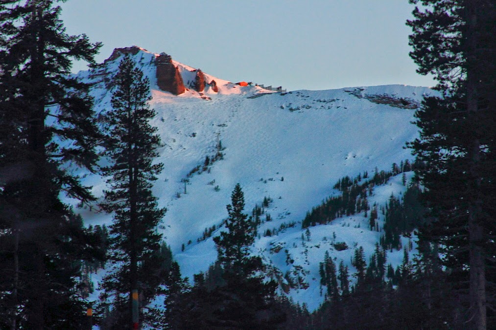
 |
| Red Cliffs, after the storm. A great April Fool's Day joke. Kirkwood, California |
Expect more of the same, if not getting a little warmer, the next two days. Right now, Monday is looking the warmest, but really, it will be a luck of the draw kind of thing. Upper 70s. Then on Wednesday, a decent sized storm tries to move on shore well north of us. This will knock the day time highs down a bit. Expect us to top out at 70F. But, here is the suck. Usually, these systems either bring us a little rain, followed by fine weather, or the keep the high pressure squarely on top of us. In the second scenario we get warmth and light winds. Instead, on Thursday, it looks like the high pressure will redevelop to our north and west, in its summertime position. And you know what that means. Gloom. Grey. Fog. Boo. Yup. Starting Thursday, and into the following weekend, we could see summer time weather developing. Marine layer fills in overnight and last through late morning. It will feel cool and damp and daytime highs will be sitting around the mid 60s. And to make matters even worse, this high pressure in this location is much harder for any incoming storms to displace. That mean it will become increasingly difficult to get much needed rain water into the state. More boo. But what can you do? I don't make the weather, just report on it. In the meantime, get outside. It is gorgeous.
Friday, April 4, 2014
The high is about to blow up.
So, I think I said I did not think we would actually get any rain from this storm. I felt that way, right up until I woke up this morning (or rather, when I was woken up) at 6:30 this morning and looked outside and saw a huge grey cloud on top of us. I mean, thick grey. I slept though the rain last night, but the wet ground confirmed something had happened. I think I also said sporadic showers if it did rain, and that is basically what we got. Total accumulation will vary greatly, but town basically got about a tenth of an inch and Ben Lomond a quarter. Actually not bad, as every drop counts. As of April 1st, the Central Coast is still rated Exceptional. That might drop to Extreme in parts once Tuesday's storm water is calculated in. The northern Sierra and southern Cascade region has dropped from Extreme to Severe, and we will likely see the region of Severe increase in the north. All good news, but Severe still sounds pretty severe. And we don't have any additional water coming in wit this forecast. Maybe it is not that bleak, but read on.
Like I said, the bubble is gonna build up upon us. Cool today. Mild tomorrow. Warm Sunday. Might be hot is spots mid week. Then it settles a bit. And in case it matters to you, the skiing this past week was pretty much the best of the season. Wintery snow will be sticking around up high, so you might want to go hit the slopes this weekend if you can. There is still snow on the trees at Kirkwood on all but west and south (which there are few) aspects. By Sunday, the warmth and sun will become too much and you can pretty much expect a springtime snowpack developed by the end of the day. Overnight lows are about freezing and the sky clear, so it will be game on for corn harvest by Monday. Nice to get the past week's worth of snow, and save a little spring skiing season for us.
Back home we can expect upper 60s on Saturday and low 70s Sunday. Temps build through Wednesday. I still think 80F is within the realm of reason. Then, as a system falls apart to our north, we will get a little cooling Thursday. Low 70s through next weekend. I don't see rain making an appearance. Not ready to say there is no chance, as moisture will be available nearby, meteorologically speaking, but it does not look like it will make inroads. There still is a strong suggestion that by mid month a storm door could open, but that is still two weeks away. So confidence low. But it sure would be nice to get some more water. Things are slightly improving, but we need more. And I don't mind another round of powder in my life.
I'm back on the road this weekend, so I'll aim for a post on Monday. Maybe something brief this weekend, but I won't look out past the next 6 days until I'm sitting some where warm. In some respects, I guess I would not even need to get in the car. Go out and enjoy this town this weekend. Go hike to a waterfall. Best they have been in three years I tell ya.
 |
| Wintery? A bit. |
Like I said, the bubble is gonna build up upon us. Cool today. Mild tomorrow. Warm Sunday. Might be hot is spots mid week. Then it settles a bit. And in case it matters to you, the skiing this past week was pretty much the best of the season. Wintery snow will be sticking around up high, so you might want to go hit the slopes this weekend if you can. There is still snow on the trees at Kirkwood on all but west and south (which there are few) aspects. By Sunday, the warmth and sun will become too much and you can pretty much expect a springtime snowpack developed by the end of the day. Overnight lows are about freezing and the sky clear, so it will be game on for corn harvest by Monday. Nice to get the past week's worth of snow, and save a little spring skiing season for us.
Back home we can expect upper 60s on Saturday and low 70s Sunday. Temps build through Wednesday. I still think 80F is within the realm of reason. Then, as a system falls apart to our north, we will get a little cooling Thursday. Low 70s through next weekend. I don't see rain making an appearance. Not ready to say there is no chance, as moisture will be available nearby, meteorologically speaking, but it does not look like it will make inroads. There still is a strong suggestion that by mid month a storm door could open, but that is still two weeks away. So confidence low. But it sure would be nice to get some more water. Things are slightly improving, but we need more. And I don't mind another round of powder in my life.
I'm back on the road this weekend, so I'll aim for a post on Monday. Maybe something brief this weekend, but I won't look out past the next 6 days until I'm sitting some where warm. In some respects, I guess I would not even need to get in the car. Go out and enjoy this town this weekend. Go hike to a waterfall. Best they have been in three years I tell ya.
Wednesday, April 2, 2014
Told ya.
Sun sure felt nice on the face this morning. We are up in the snow, and it was stunning early on. Clouds have filled back in here and flurries returned. Likely feels pretty warm down in Santa Cruz. I imagine the sun is still out down there. Similiar tomorrow. Maybe a touch cooler. Another storm is lined up to come into the coast, but it looks like it will break apart just before it comes on shore. A good portion will run into the northern end of the state, but we should stay dry. But do expect some clouds, and a chance for showers, say early Friday morning. Then the high pressure fills in.
Gonna make this short and sweet, as I need to get cleaning up around here and prepping for evening sled run. Warmth is on the way. Sunday will boost into the low to mid 70s. Would not be surprised with 80s by Wednesday. Some say more rain is possibly bound for us late next week. Or the bubble wins out. Either way, it looks like we will get some onshore winds and cooler temps after hump day. More on that later. Enjoy this coming weekend. Will be nice on the coast. And there is plenty of new snow on the hills, but expect pretty much spring conditions by this weekend.
 |
| Again from two weeks ago. There is snow hanging every where today. Kirkwood, California. |
Gonna make this short and sweet, as I need to get cleaning up around here and prepping for evening sled run. Warmth is on the way. Sunday will boost into the low to mid 70s. Would not be surprised with 80s by Wednesday. Some say more rain is possibly bound for us late next week. Or the bubble wins out. Either way, it looks like we will get some onshore winds and cooler temps after hump day. More on that later. Enjoy this coming weekend. Will be nice on the coast. And there is plenty of new snow on the hills, but expect pretty much spring conditions by this weekend.
Subscribe to:
Posts (Atom)