Sun. Surf. No Wind. Sunsets. Warm. No Rain. I tell ya, we have some of the best winter around. While a good portion of the rest of the country is wet, cold, or both, we are looking pretty fine. I just got off the plane from Virginia, where the weather was pleasant enough, if a bit crisp. It was warm when we got home today. The surf was pumping. And the sunset was another winner. You've got to love it here. I really enjoyed my trip, but it always nice to come home. And today delivered. Thing is, Santa Cruz delivered all week while I was gone. And it will deliver again all next week. Again, while I'm gone. And when I come home a few days later, it will still be delivering. So, when does this all change?
Mid 60s, and little wind. Some high clouds. Warmest Sunday. And again by Thursday. Nights in the upper 30s. Looks like it should continue like this through next weekend at least. Only bummer about this weather, is we really do need to get some water this winter. GFS keeps brining it to us starting around the 8th or so. Euro is a touch later. Been that way for several runs now. But no one is holding there breath. Before that, the weather stays pretty much the same. Another round of swell fills in tomorrow, while what is in the water is still sizable enough to have town breaks looking fun. Another round arrives Monday, and another Thursday. Oh, and the wind looks light through the period. So basically, surf is up.
I'll take a look at the forecast models over the next few days and see if we get some more agreement and consistency as we get closer. As for now, get out there and seize the day folks. It is damn awesome out.
Friday, December 27, 2013
Sunday, December 22, 2013
High and Dry.
Hey folks. I'm headed out of town in the morning to go visit family. Too bad, as the weather is ideal mid winter bliss. Cool, even crisp, mornings in the upper 30s. Afternoon highs in the low to mid 60s. Slight warming trend through Christmas Day. Nestled up against the south facing cinder block wall in the CostCo parking lot, it could top 70F. Not bad for December 25th. And the surf will be pumping this week as well, as a new NW long period mid size swell peaks on Monday and tapers through the first half of the week. Another shows as a gift from Saint Nick. Slightly cooler into the weekend. Sunshine prevails, other than just enough cloud cover to make the early winter sunsets pop.
 |
| The weather outside is not frightful. |
Wednesday, December 18, 2013
Quick update this morning. GFS has us dry, with almost a quarter inch (say 2 inches of snow) along the Tahoe peaks. Almost a half inch for L.A., and even more for the Socal mountains. Mammoth could get up to three quarters of an inch of precipitation. Not a lot going south, but the bulk of this will be well south and east of us. Feels like rain this morning though. I think that is just the warm still air pooling before the cold north west breeze develops. But it is moist. Still a slight chance for rain tonight and tomorrow.Could be a good few days to get some errands done, or find something to do inside. We might hit up the Monterey Bay Aquarium Thursday. We like to park for free out along the coastal bike path, and walk back to the aquarium while looking for seals, otters and birds. Memberships are a great holiday gift to give to a family (I should know, we have received this gift for two years in a row). And tax deductible, for you finance savvy folks out there. In April, or May, the Tentacles exhibition will be open. Another thing to do inside, starting this Friday, is the train exhibit at the Santa Cruz Museum of Art and History. If your young one, or you yourself, love a good model train set up, this is the thing for you. And it is free, but, hey, membership here is less expensive, and supports a good place. We built snow flakes there recently.
Okay, likely no rain. But still plan for a drizzle, or cool ominous clouds, at least. Clearer and warmer Friday. Weekend looks fine. Could see another warm up.
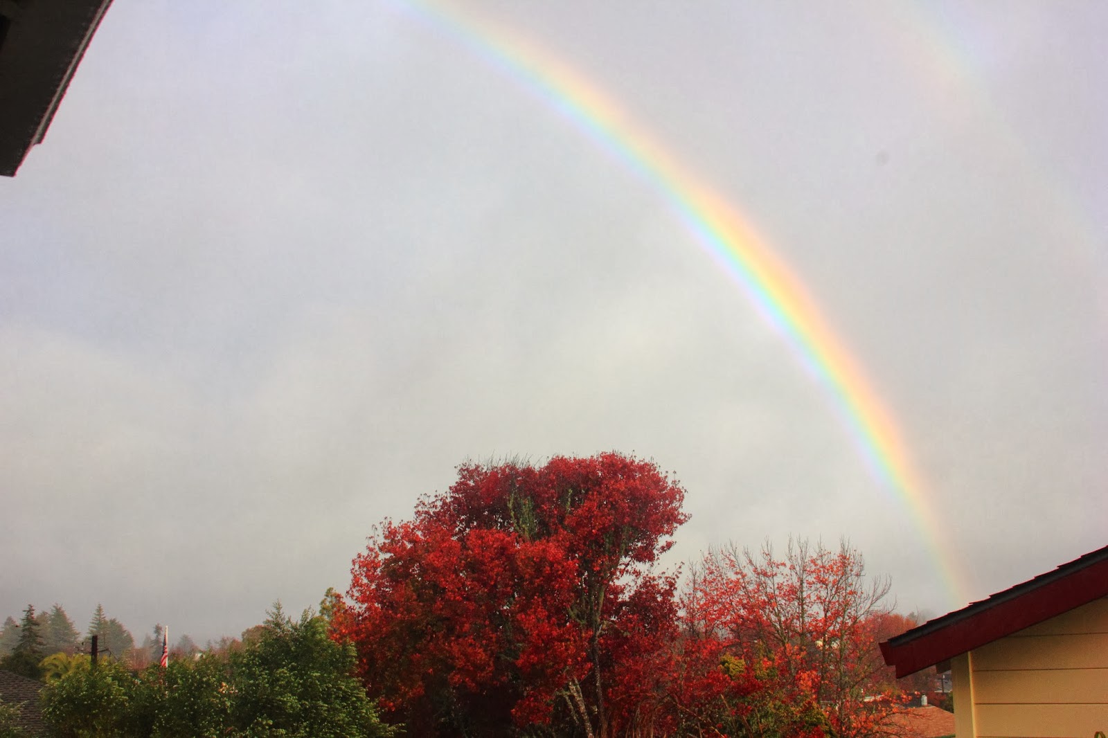 |
| Autumn storm brings color to the sky. Hard to see, but that was a double rainbow, dude.... |
Okay, likely no rain. But still plan for a drizzle, or cool ominous clouds, at least. Clearer and warmer Friday. Weekend looks fine. Could see another warm up.
Tuesday, December 17, 2013
Looking mostly dry. Mostly.
I wanted to wait till this morning to get a better feel for the trend this week. On Sunday, the GFS shifted to a much wetter, and a touch cooler, solution. Since then it has been slowly backing off from that toward a drier, if not dry, solution. Now we are two days out, so lets take a closer look at it. Pleasant day today. Not quite as warm as yesterday, but still quite nice. Speaking of yesterday, if you were watching TV at sunset, you were doing it wrong. One of those magical evenings out there. I was lucky enough to be in the water along West Cliff when dark slowly settled in. Such an absolutely beautiful late autumn evening. Upper 60s today in the best corners of town, with a thin high haze, and maybe some low fog along the water. That fog could fill in tonight, as the winds are basically calm out there. Wednesday will start off quite mild in the low to mid 40s. But it won't warm up much, as a cold north west breeze develops through the day. Highs stay in the 50s.
So, there is a pretty solid swell running right now. At least solid for this anemic season. And with these calm conditions, the surf is breaking really nicely. Should be another solid day today. As the swell backs off, and the wind kicks up, the conditions will deteriorate. But not to worry. We will get some big windswell mid week. As the weather calms late in the week, more small mid period swell arrives. By next week, it could be big again. And it looks to stay rideable through next week. Finally, maybe the season has started up.
So the weather calms. Thursday could be a stormy day, with some wind and clouds. We could even see a bit of rain, but it does not look likely at this point. The Sierra Crest still might squeeze out a few inches of snow. But it is mostly only going to bring that colder air, with lows back in the 30s and the highs back in the 50s. Luckily, it will not quite last like the last bought of cold, as high pressure quickly builds and pumps back in the warm air. Not like yesterday warm, but warm. Low to mid 60s starting Saturday. And no signs of cooling or storms in the mid term. Bubble of high could keep us dry through the year. If you collect your own rain water, you should be conserving right now. Until winter starts, we really can count on anything.
 |
| Stealing one of my wife's pics. Persimmons, UCSC Campus Farm. |
So, there is a pretty solid swell running right now. At least solid for this anemic season. And with these calm conditions, the surf is breaking really nicely. Should be another solid day today. As the swell backs off, and the wind kicks up, the conditions will deteriorate. But not to worry. We will get some big windswell mid week. As the weather calms late in the week, more small mid period swell arrives. By next week, it could be big again. And it looks to stay rideable through next week. Finally, maybe the season has started up.
So the weather calms. Thursday could be a stormy day, with some wind and clouds. We could even see a bit of rain, but it does not look likely at this point. The Sierra Crest still might squeeze out a few inches of snow. But it is mostly only going to bring that colder air, with lows back in the 30s and the highs back in the 50s. Luckily, it will not quite last like the last bought of cold, as high pressure quickly builds and pumps back in the warm air. Not like yesterday warm, but warm. Low to mid 60s starting Saturday. And no signs of cooling or storms in the mid term. Bubble of high could keep us dry through the year. If you collect your own rain water, you should be conserving right now. Until winter starts, we really can count on anything.
Sunday, December 15, 2013
Maybe a shower?
I sure need one. his mornings run of the GFS has the storm for Thursday looking much more impressive, but still staying mostly away from us. Out to sea it the thought today. But this scenario would bring us some clouds and light showers for Thursday. I'll keep an eye on this, and give you a more in depth look tomorrow night. This system is to split from the Jet Stream, so it will really be quite unpredictable, but we will try to make an educated guess. Right now it seems wise to plan for a little wetness Thursday. Not too much though. And not enough to make for some real snow. In the meantime, if you use Instagram, follow therealweather for current up to date pictures of our weather. Maybe I will even tweet soon.
Anyway folks, if the storm does dive down the coast, and pick up moisture, it will likely bring cooler weather by Wednesday. Still super nice on Monday. Warm, even. Milder, but still fair on Tuesday. Cooler Wednesday, and maybe a short drizzle for Thursday. Rebound into the low 60s for the weekend. Stay tuned.
 |
| More hiking trail. Henry Cowell Redwood State Park. |
Anyway folks, if the storm does dive down the coast, and pick up moisture, it will likely bring cooler weather by Wednesday. Still super nice on Monday. Warm, even. Milder, but still fair on Tuesday. Cooler Wednesday, and maybe a short drizzle for Thursday. Rebound into the low 60s for the weekend. Stay tuned.
Saturday, December 14, 2013
Great time to work on a holiday tan.
Seriously, this weekend and the start of next week look splendid for mid December. We have moved solidly into the 60s for today, with upper 60s for Sunday and moving into the 70s on Monday. Over night, with the calm winds, it is still pretty chilly. Upper 30s, but still some frost development. We saw frost still on the ground at noon, both Wednesday and Thursday, tucked up near the red woods. That is some cold folks. Mornings will be slightly warmer during the start of the week. Say, low to mid 40s. But not for long. More cold is on the way. Get your tan on while it is warm enough to remove some garments. No rain in the forecast.
After Monday, it will not be as warm, but it won't be cold. Mid 60s. Then Thursday, a mostly dry system crashes south and brings us another round of cold air. Lows in the mid 30s. Highs in the upper 50s. Not quite as cold as the last system, but chilly none the less. This system once looked like it would bring some rain somewhere. Now we will be lucky to squeeze and inch of snow out of it at high elevations. And no real water is showing up in the mid and long term right now. It could be a very dry month. The ski resorts could really use a good dump before the holidays, and the state could use the water. Fingers crossed, but it does not look likely. Well, back to completing work in the yard. In the meantime, the surf is real good, with finally some swell and nice clean conditions. Bigger swell for Monday. Wear a hood, It is cold out there. I'll post up again early next week, looking at the surf and coming cold. And I'll keep an eye out for rain. Like I said, this would be a good weekend o be up skiing. Nice weather, and the snow we do have is fun, and it is only getting older. Hell, Kirkwood opened Chair 6 today, so Tahoe does have some steeps on offer.
 |
| Get it while it is good. Kirkwood ridge line. |
After Monday, it will not be as warm, but it won't be cold. Mid 60s. Then Thursday, a mostly dry system crashes south and brings us another round of cold air. Lows in the mid 30s. Highs in the upper 50s. Not quite as cold as the last system, but chilly none the less. This system once looked like it would bring some rain somewhere. Now we will be lucky to squeeze and inch of snow out of it at high elevations. And no real water is showing up in the mid and long term right now. It could be a very dry month. The ski resorts could really use a good dump before the holidays, and the state could use the water. Fingers crossed, but it does not look likely. Well, back to completing work in the yard. In the meantime, the surf is real good, with finally some swell and nice clean conditions. Bigger swell for Monday. Wear a hood, It is cold out there. I'll post up again early next week, looking at the surf and coming cold. And I'll keep an eye out for rain. Like I said, this would be a good weekend o be up skiing. Nice weather, and the snow we do have is fun, and it is only getting older. Hell, Kirkwood opened Chair 6 today, so Tahoe does have some steeps on offer.
Wednesday, December 11, 2013
Warming.
No a whole lot, but it is there. Yesterday morning seemed about the coldest for the spell. At least in my yard, and based upon my very scientific 'frost on car' visual check. Anyway, today will move into the mid 50s, and tonight we will stay in the mid to upper 30s. So, yeah, right toasty. The real news for today is the warming that might show for the coming weekend. The rest of the week will like kind of like today. Perhaps a touch warmer each day. Highs for the weekend could be in the mid 60s and even warmer for Sunday and Monday. It will depend on how this high pressure sets up over us. But at the very least, we are in for a run sunshine.
Don't get me wrong. It is still cold out there. We saw frost crystals still on the ground at 11AM in Harvey West Park. Now, this is a spot that rarely sees the sun this time of year, but still, that is cold. The ground actually felt semi frozen there. But, with a little luck, we could be pushing 70F in some parts of town by next Wednesday. If that comes to pass, it will feel positively warm. I might just head to the beach. In the meantime, the surf is running fairly small, and fairly clean. Size should pick up later in the week, and we could see chest to head high surf through the weekend, with maybe a bigger pulse on Monday. With the calm, and warm, weather, it could make for some fun surf.
Next chance at a weather change looks to be late next week. If you have been reading this fall, you know my confidence in the mid and long term is very, but I thought I'd give this a mention, as it has shown on the models several runs in a row now. Basically, an Alaskan system could break through the high pressure, bringing another round of cold air and rain for late next week. Or not. Check back here to see how things start to pan out over the next few days.
 |
| The Sierra gets a blanket. Check it out here. |
Don't get me wrong. It is still cold out there. We saw frost crystals still on the ground at 11AM in Harvey West Park. Now, this is a spot that rarely sees the sun this time of year, but still, that is cold. The ground actually felt semi frozen there. But, with a little luck, we could be pushing 70F in some parts of town by next Wednesday. If that comes to pass, it will feel positively warm. I might just head to the beach. In the meantime, the surf is running fairly small, and fairly clean. Size should pick up later in the week, and we could see chest to head high surf through the weekend, with maybe a bigger pulse on Monday. With the calm, and warm, weather, it could make for some fun surf.
Next chance at a weather change looks to be late next week. If you have been reading this fall, you know my confidence in the mid and long term is very, but I thought I'd give this a mention, as it has shown on the models several runs in a row now. Basically, an Alaskan system could break through the high pressure, bringing another round of cold air and rain for late next week. Or not. Check back here to see how things start to pan out over the next few days.
Monday, December 9, 2013
Continued Cold, but Slight Warming will feel nice.
Man is it chilly out there. Last night I pulled into the driveway around 10pm. It was 35F. Colder than 10PM on Thanksgiving, at 7800'. At 8AM, at 7800 feet, it was -9F. Even colder in the high elevation valleys. South Lake was -15F. Lucky for us, we live in sunny and warm California. The real cold was in the interior of the country where temperatures as low at -40F (and colder) were recorded. Mornings will remain cold, but they will slightly moderate by the end of the week. Daytime temps will be on the rise and we are in for a stretch of sunshine. About 50F today. Maybe a touch warmer. Clear and cold tonight with a freeze warning in effect. Continue to care for the needy people, pets and plants. Maybe take a moment and check in on a fellow human being. Some cold folks over the past few nights. Tuesday will be warmer still, clocking in at about 55F.
Wednesday morning will not be as cold, but still, some areas may drop below 32F. Still watch those plants. The rest of the week it looks like lows in the mid 30s and the highs in the upper 50s. The weekend will be warmer still with lows about 40F and highs about 60F. Right toasty. High pressure is setting up over the west and we should be storm free for a week or more. So, let us check in on the snow. Tahoe area resorts received from 1 to 3 feet of very light, dry snow from Friday's storm. If this were wet, heavy snow, it would be a big game on. But it helps. So does the cold and snow guns. Kirkwood is now running 3 lifts, with both on and off piste zones open, offering a nice, small variety of skiing options. I hear Sugarbowl has decent natural coverage as well. Most of the other resorts are mostly operating on manmade surfaces at this time. Northstar has a lot of groomed mileage, and with Burnout now open, at least something to develop leg burn on. I tell ya, that is one of the best places to hit up in White Ribbon Season. No storms on the horizon, and what looks like a relatively dry December has some folks worried. I say go on up and hit it now. Now, through this coming weekend, the snow should hold up nicely. Cool days keep the natural stuff in decent shape, and cold nights allows for the guns to blow. We need more to see the resorts really pop open, but we have a good start. Fingers crossed, but to be honest, I am not minding the though of another ten days of sunshine. And maybe a little bit of warmth too.
 |
| San Lorenzo River, Henry Cowell State Park, Felton, California. Late Autumn. |
Wednesday morning will not be as cold, but still, some areas may drop below 32F. Still watch those plants. The rest of the week it looks like lows in the mid 30s and the highs in the upper 50s. The weekend will be warmer still with lows about 40F and highs about 60F. Right toasty. High pressure is setting up over the west and we should be storm free for a week or more. So, let us check in on the snow. Tahoe area resorts received from 1 to 3 feet of very light, dry snow from Friday's storm. If this were wet, heavy snow, it would be a big game on. But it helps. So does the cold and snow guns. Kirkwood is now running 3 lifts, with both on and off piste zones open, offering a nice, small variety of skiing options. I hear Sugarbowl has decent natural coverage as well. Most of the other resorts are mostly operating on manmade surfaces at this time. Northstar has a lot of groomed mileage, and with Burnout now open, at least something to develop leg burn on. I tell ya, that is one of the best places to hit up in White Ribbon Season. No storms on the horizon, and what looks like a relatively dry December has some folks worried. I say go on up and hit it now. Now, through this coming weekend, the snow should hold up nicely. Cool days keep the natural stuff in decent shape, and cold nights allows for the guns to blow. We need more to see the resorts really pop open, but we have a good start. Fingers crossed, but to be honest, I am not minding the though of another ten days of sunshine. And maybe a little bit of warmth too.
Saturday, December 7, 2013
Cold Weekend, but things clear out early.
The storm has pretty much passed for us here in Santa Cruz. Clouds still block the view to Monterey, so they could have more morning showers. Radar shows there is still a little bit of action to our west, so we could still see some light showers sporadically this morning. Go downtown and enjoy the holiday parade. Much better out there than forecasted. But bundle up. It is still cold. And more cold air filters in tonight, although, it does not look like it will be quite as chilly as expected. Low 30s for us in town, maybe dropping to the upper 20's in the local mountains. The inland valley will be freezing, with extended periods in the low 20s. We might have some citrus issues from this chill.
Sunday we struggle to break into the 50s again. Slight warming trend for the coming week. Models are all over the place for the weather late in the week, so I will likely watch a few runs and update for that on Monday. Right now I am just enjoying the morning sunshine and the fact that this storm cruised through our area pretty quickly. I doubt we even got a 1/4 inch yesterday, let alone the 1/2 inch the GFS called for. While this system did speed through our area, it has settled down in the Sierra where a foot or two fell last night, and more continues to fall. Expect those ski resorts to start opening up more terrain. It is very light blower snow, so it will not get a lot of the steeper and rockier stuff to pop, but you probably will be able to ski a bit more than the white ribbon. I might head on up to check it out tomorrow. It is not like the surf looks all that promising this weekend. Maybe a small swell for Monday. And I know some of you like a wet bike trail, but I don't need another cleaning project on my hands. More on Monday.
 |
| A great place to be after, or during a rain. Among Redwoods. Henry Cowell SP. |
Sunday we struggle to break into the 50s again. Slight warming trend for the coming week. Models are all over the place for the weather late in the week, so I will likely watch a few runs and update for that on Monday. Right now I am just enjoying the morning sunshine and the fact that this storm cruised through our area pretty quickly. I doubt we even got a 1/4 inch yesterday, let alone the 1/2 inch the GFS called for. While this system did speed through our area, it has settled down in the Sierra where a foot or two fell last night, and more continues to fall. Expect those ski resorts to start opening up more terrain. It is very light blower snow, so it will not get a lot of the steeper and rockier stuff to pop, but you probably will be able to ski a bit more than the white ribbon. I might head on up to check it out tomorrow. It is not like the surf looks all that promising this weekend. Maybe a small swell for Monday. And I know some of you like a wet bike trail, but I don't need another cleaning project on my hands. More on Monday.
Friday, December 6, 2013
Rain Overnight.
Coming in after sunset, although clouds could fill more this afternoon. Onset before midnight, with heaviest rain subsiding just about daybreak. Rain tapering through the day. Cold. Colder again tomorrow night, with temps forecast below freezing by early morning. Will depend on cloud clover. Less means colder. Really try to get out there and protect your loved ones. This will be the coldest morning yet. Sunday will be a chilly one. Warming through mid week. More later today when I have a chance to sit.
Evening Edit: I felt the first drops around 3:30 today, and we had a steady rain develop by night fall. Brunt of the system is still to hit later tonight, but it looks like we received precipitation from a few forward bands. I can hear a steady pitter patter on the roof top. Look around the local hills tomorrow for snow on top. Could be a beautiful one, if chilly. Sunday still looks cold, and we could drop below freezing for a few hours, even right up to the coast.
 |
| Along the trail. Henry Cowell SP. |
Evening Edit: I felt the first drops around 3:30 today, and we had a steady rain develop by night fall. Brunt of the system is still to hit later tonight, but it looks like we received precipitation from a few forward bands. I can hear a steady pitter patter on the roof top. Look around the local hills tomorrow for snow on top. Could be a beautiful one, if chilly. Sunday still looks cold, and we could drop below freezing for a few hours, even right up to the coast.
Thursday, December 5, 2013
Splitting the difference. Rain should begin around night fall Friday. Wet Saturday.
The GFS continues to hold off on the start of rain, but other models and outlets call for rain by mid day Friday. Everyone agrees that there will be rain. NWS backed off on the timing as well. All in all, it looks like a fast, quick storm, that will drop a decent amount of rain over night. Showery weather breaks apart during the day, and we could even see some sun (fingers crossed) by afternoon. But with a good half inch expected, the ground will be fairly wet on Saturday. And it will be breezy, as well. Cold air follow behind the storm, and if those sky is clear, we could dip down into the 20s for early Saturday morning. Brr. We could be stuck in the high 40s for Sunday, but at least the wind will back down. Brrrrrrrrr. Much warmer on Monday, but still in the mid 50s. Low to mid 60s by mid week, which will feel right warm after these days. But we could be looking at another storm to finish off the week. Folks, this is going to feel like a winter weekend. Be prepared.
I'll take a final look at this storm, and the coming week tomorrow morning. For now, stay bundled up, and keep watching out for your plants, pets and folks living outside.
I'll take a final look at this storm, and the coming week tomorrow morning. For now, stay bundled up, and keep watching out for your plants, pets and folks living outside.
Wednesday, December 4, 2013
Model slows approach.
Just a quick one today. This morning's run slows the approach of the system for the weekend. Rain looks to develop sometime on Saturday, likely in the morning, and lasting through the day. This keeps the system over water longer, and allow for it to hit us more fully. Could be a pretty wet day. Heaviest rain presently looks to be around nightfall, with things fairly cleared out by Sunday. Freezing levels could drop below 2000 feet, which allows for some snow locally. It would be nice if we could see some on the peaks in the morning.
It should be noted that the NWS still has this coming in on early Friday, about 30 hours before the GFS. That is super significant given we are only 36 hours out from the earlier arrival time. Something to monitor. We are looking at a half inch of liquid as far south as at least Carmel. Well over in inch in the Sierra. We could get some decent snow this weekend, especially with the cold. Not really the sloppy base builder we need, but better than nothing. Expect more terrain opening, especially with the big man made and low angled resorts. I'll update this all tomorrow as to timing and rainfall. And don't forget, it is going to be freezing tomorrow morning. Already pretty damn cold today. Ahh, winter time. Just hung the lights. Don't be surprised if these numbers all peddle back tomorrow.
It should be noted that the NWS still has this coming in on early Friday, about 30 hours before the GFS. That is super significant given we are only 36 hours out from the earlier arrival time. Something to monitor. We are looking at a half inch of liquid as far south as at least Carmel. Well over in inch in the Sierra. We could get some decent snow this weekend, especially with the cold. Not really the sloppy base builder we need, but better than nothing. Expect more terrain opening, especially with the big man made and low angled resorts. I'll update this all tomorrow as to timing and rainfall. And don't forget, it is going to be freezing tomorrow morning. Already pretty damn cold today. Ahh, winter time. Just hung the lights. Don't be surprised if these numbers all peddle back tomorrow.
Tuesday, December 3, 2013
Could it be Drought Year, Again?
The zoo is all in a chatter about how this could be the third one in a row. A slow start, after what looked like it might be a promising fall, an experimental model, and age old fear mongering has got every one concerned that this could be another poor year for snow. While the hopefuls are just claiming it has not turned on yet, but once it does, it will dump. What ever your perspective, it seems like the start of winter has been off since the big year that started in October of 2003. That is a decade. Anyway, models are doing what they seem to have been doing the past two winters. It always looks like we are going to get slammed by a big wet set up in ten days time. At least now, we are seeing some precipitation in the mountains and actually have more forecast for Friday night. Let's focus in this week for now.
Still a very slight chance for showers out there locally, but it is much more concentrated in the Sierra with the very cold temperatures. Maybe a foot will fall atop Kirkwood, but this snow is very light and will settle down to 2-4 inches, if it does not first get blown away. It is cool out there today, with a gusty wind. Kind of feel like Fall that I remember as a kid in New England. But more like an early November day there. Tonight will be cold, but high clouds and wind keep us just above freezing. About 35F tonight and 50F on Wednesday. And clearing. Thursday night will get cold, and you will want to consider you plants and pets. And anyone you know living outside. Make sure they stay warm. If you have tender plants, cover them up, especially in low, shaded areas. I like to make sure the soil is well watered before a cold snap. Unless you have succulents. Then you pray. But I don't think it is going to get that cold in most places to really hurt mature plants. SLV, and such locales, OTOH, could get a freeze. Certain north sloping valleys at elevation in the Santa Cruz Mountains could dip below 25F. Back up to 50F or so across the region. Tahoe is be in the 20s. More of the same through Friday morning. Then we need to watch this next system that is on the charts.
Right now, it looks like we could get a similar storm as today's moving through, only its track will be a bit further south and west, driving the bulk of the system through just to our north and east. This will give us a much greater chance for rain, but the real heavy stuff seems like it will hit Sacramento and the West Slope. At least the rain will warm things up a little bit. The day Friday should warm to 55F, with clouds and late day rain. Overnight, we should be above freezing here in town, but snow could fall on certain peaks around Monterey Bay. With a little luck, we could have some snow caps in the morning. Clouds, though, may obstruct them. If the day does not melt it, sunset could pull together for a nice view. Saturday will be crisp, with the cold air filling in behind the storm. Right now, high pressure fills in, bringing cool air, sunshine, and slow warming. Rain again Thursday, or 10 days out.
Come back tomorrow. If there is any shift in the forecast for Friday, I'll post it up. For now, dry and cold until Friday, when it warms a bit, and rains, then cool and dry starting Sunday.
 |
| Cell phone pic, 'cause these guys are around. Mostly at NBs, but a swath of them at Lighthouse Field. |
Still a very slight chance for showers out there locally, but it is much more concentrated in the Sierra with the very cold temperatures. Maybe a foot will fall atop Kirkwood, but this snow is very light and will settle down to 2-4 inches, if it does not first get blown away. It is cool out there today, with a gusty wind. Kind of feel like Fall that I remember as a kid in New England. But more like an early November day there. Tonight will be cold, but high clouds and wind keep us just above freezing. About 35F tonight and 50F on Wednesday. And clearing. Thursday night will get cold, and you will want to consider you plants and pets. And anyone you know living outside. Make sure they stay warm. If you have tender plants, cover them up, especially in low, shaded areas. I like to make sure the soil is well watered before a cold snap. Unless you have succulents. Then you pray. But I don't think it is going to get that cold in most places to really hurt mature plants. SLV, and such locales, OTOH, could get a freeze. Certain north sloping valleys at elevation in the Santa Cruz Mountains could dip below 25F. Back up to 50F or so across the region. Tahoe is be in the 20s. More of the same through Friday morning. Then we need to watch this next system that is on the charts.
Right now, it looks like we could get a similar storm as today's moving through, only its track will be a bit further south and west, driving the bulk of the system through just to our north and east. This will give us a much greater chance for rain, but the real heavy stuff seems like it will hit Sacramento and the West Slope. At least the rain will warm things up a little bit. The day Friday should warm to 55F, with clouds and late day rain. Overnight, we should be above freezing here in town, but snow could fall on certain peaks around Monterey Bay. With a little luck, we could have some snow caps in the morning. Clouds, though, may obstruct them. If the day does not melt it, sunset could pull together for a nice view. Saturday will be crisp, with the cold air filling in behind the storm. Right now, high pressure fills in, bringing cool air, sunshine, and slow warming. Rain again Thursday, or 10 days out.
Come back tomorrow. If there is any shift in the forecast for Friday, I'll post it up. For now, dry and cold until Friday, when it warms a bit, and rains, then cool and dry starting Sunday.
Monday, December 2, 2013
Them models sure are pretty, but, damn are they flaky.
No real change in the short term. Cold air is filling in, maybe some clouds tonight. real slight chance of rain overnight and through tomorrow. System is moving a bit slower on today's run, so if it does bring moisture, it could last a bit longer. Six inches for Tahoe. Much cooler tomorrow and into Wednesday. We could seeing freezing temperatures on the coast Thursday and Friday morning. That is all basically the same. But the big blocking high on last night's run, is gone this morning. Late Friday a small low pressure that develops off the BC coast shifts south and could move across our region bringing coastal rain and mountain snow. So, yeah, there is that. And another one sets up for Monday. I'll watch the models and update on this when, and if, I gain any sort of confidence in the mid and long term. For now, let us just bundle up and stay warm for the next few days. Protect your outdoor plants and animals. Bust out the oil heater for the infants room. Put on a sweater and extra duvet. It is gonna be a cold few days for us beach people.
Check on back here for updates regarding the end of the week and the weekend. If these storm show again on the next model runs, I'll start trying to hone in on timing. Could be a wet, and cool, Saturday morning.
 |
| Missing the summer time watering hole. |
Check on back here for updates regarding the end of the week and the weekend. If these storm show again on the next model runs, I'll start trying to hone in on timing. Could be a wet, and cool, Saturday morning.
Sunday, December 1, 2013
Looking Dry, Breezy and Cold.
Freezing actually, by early Thursday morning. But first, I apologies for my lack of update concerning the epic weather we just experienced this past weekend. I saw it coming via my phone, but lacked an internet connection to update this page. Maybe I need to set up a twitter feed. Anyway, it was lovely out. Hoped you didn't stay inside all weekend watching football or something. And the surf was not too shabby either. But, let us look at what is to come. Basically, coldness. Monday will start off not too different than this morning, in the low to mid 40s. The day will begin quite nice, but a stiff northwest breeze will develop by afternoon and begin ushering in cooler air. What was low 70s today will be mid 60s tomorrow. Then things start to get chilly.
A cold front is expected to arrive on Tuesday with cold Canadian air behind it. It looks like this system may produce some light snow showers in the Sierra, but we will likely remain dry here in Santa Cruz. Still, slight chance for a drizzle. Very good chance for coldness. Highs should only reach into the low to mid 50s. Windy conditions prevail, which actually will help keep the early morning lows from dropping into the freezing zone here in Santa Cruz. Let us say it will only be a brisk 35F. Not quite freezing. Other inland areas around the Bay are likely to see some sort of freeze Wednesday morning. Winds will begin to subside, but with the cold air in place, daytime highs will struggle to reach much past 50F. Then as the night time sky clears, and the wind stops, Thursday morning will be very cold with freezing temperatures expected across our county, right up to the coastal bluffs. We may see 32F on West Cliff Drive. It then looks pretty much the same through Sunday, with slight increases in daytime highs, maybe getting back to the mid 50s by the start of next week.
Okay, so I am sure your gutters are clean by now if you have been listening to me. You will thank me latter when we actually do get some real rain. But now you need to start thinking about your young winter gardens or frost sensitive plants. Not sure yet just how cold this thing will get, but we are looking at temps way below average for early December. These are cold overnight lows for any time of year. Use floating row covers or other tenting devices to protect your plants. We are looking at Wednesday through Friday night at least. Maybe even into next week. For you snow schussers, this thing is not a going to be a big producer and will do little for improving our lack of base, but it will help the resorts with snow making. Guns should be firing all day by mid week. I guess that is exciting. More as we start seeing this cold air impact our region. Bundle up buttercup.
 |
| It will be quite at the beaches this week at least. |
A cold front is expected to arrive on Tuesday with cold Canadian air behind it. It looks like this system may produce some light snow showers in the Sierra, but we will likely remain dry here in Santa Cruz. Still, slight chance for a drizzle. Very good chance for coldness. Highs should only reach into the low to mid 50s. Windy conditions prevail, which actually will help keep the early morning lows from dropping into the freezing zone here in Santa Cruz. Let us say it will only be a brisk 35F. Not quite freezing. Other inland areas around the Bay are likely to see some sort of freeze Wednesday morning. Winds will begin to subside, but with the cold air in place, daytime highs will struggle to reach much past 50F. Then as the night time sky clears, and the wind stops, Thursday morning will be very cold with freezing temperatures expected across our county, right up to the coastal bluffs. We may see 32F on West Cliff Drive. It then looks pretty much the same through Sunday, with slight increases in daytime highs, maybe getting back to the mid 50s by the start of next week.
Okay, so I am sure your gutters are clean by now if you have been listening to me. You will thank me latter when we actually do get some real rain. But now you need to start thinking about your young winter gardens or frost sensitive plants. Not sure yet just how cold this thing will get, but we are looking at temps way below average for early December. These are cold overnight lows for any time of year. Use floating row covers or other tenting devices to protect your plants. We are looking at Wednesday through Friday night at least. Maybe even into next week. For you snow schussers, this thing is not a going to be a big producer and will do little for improving our lack of base, but it will help the resorts with snow making. Guns should be firing all day by mid week. I guess that is exciting. More as we start seeing this cold air impact our region. Bundle up buttercup.
Subscribe to:
Posts (Atom)