Gusty north west winds have filled in behind this morning's storm. I can see the nearby palms leaning hard to the east. We collected nearly a third of an inch this morning. Added to the four tenths we received on Friday, we totaled nearly three quarters of an inch of rain. A little more than forecast. All in all, this system, played out as expected. Although breezy and cool (it is currently 57F at 3PM), it is a pleasant day out. Tomorrow looks like more of the same. The big news is that these winds are ushering in our first solid high pressure system since early December. We are looking at possible a ten day dry spell. That typically means slowly warming days.
Tomorrow looks much like today. Strong winds and cool temps. Lows begin the week in the low 40s with the highs in the upper 50s. By the end of the work week, daytime highs will be pushing into the low, or even mid 60s. Early morning lows will remain in the 40s. The sky will be mostly clear. Winds moderate by Wednesday. Outlook if for the next chance of storms around 11th.
Sunday, January 31, 2016
Friday, January 29, 2016
Basically on track.
Drizzle showed up early this morning. I heard one adult claim it is just fog. The kid near by and set them straight. It was drizzle. It accumulated. We are just over a tenth of an inch on the west side, nearly a quarter of an inch at Fall Creek, and over a third of an inch on the Sierra west slope. In fact, they are expecting some heavy precipitation up there, with snow levels above 8000 feet right now. Those will lower to lake level overnight. About a foot of snow or so at the higher elevations. A few inches down at the lake. Just some light drizzle down here on the coast. Again, that looks to let up by tomorrow morning. We still need to consider that we will continue to see high humidity, and with the onshore breeze, we could see some more drizzle during the day. Lows overnight around 50F. Highs on Saturday about 60F.
Colder air moves in tomorrow though, and we see increased chances of showers by Saturday evening, and into Sunday morning. A low of 45F. A high of 55F on Sunday. So cooler. This second wave is going to mainly hit to our south on Sunday afternoon. If that tracks further north, we could see some moderate rain on Sunday. Likely, we will accumulate less than a quarter inch from noon Saturday through Monday morning. What will be dramatic is the winds filling in behind the storm on Monday, High pressure is setting up shop, and will try to re-enforce itself. That drives brisk northwest winds. Just like after a spring storm. And while there is a short wave likely to break through a bit on Tuesday evening, this high pressure otherwise looks to set up for a solid ten day stretch of sunshine. Time to think about heading out on some of those bigger hikes. Either to waterfalls or alpine lines.
Tahoe should fair well this weekend. Lots of rain hitting things right now. But there will be snow down to all elevations by Saturday morning. Good base building snow. It would be nicer to get fluff. Winds might also be an issue at higher elevations where the lighter snow awaits. The Sunday storm looks colder, and Monday may be the day. Next week looks very nice, with perhaps some clouds and light snow showers to preserve the surface. Things are setting up pretty nicely for the President's week holiday.
EDIT: Two things. Raining now at 8:45. Almost up to a quarter inch. Looks like we will exceed forecast tonight. Oh, and I almost forgot to tell you. West Cliff fell sidewalk fell into the ocean just east of Woodrow. Insane. A new blow hole coming up through the sidewalk. The city employee said at the higher morning tide, with more swell, he could here the boulders bellow tumbling around like marbles. Holy mother nature el nino batman. Anyway, pretty cool power of nature stuff.
 |
| King Tides at 3 Mile, January 2015. |
Colder air moves in tomorrow though, and we see increased chances of showers by Saturday evening, and into Sunday morning. A low of 45F. A high of 55F on Sunday. So cooler. This second wave is going to mainly hit to our south on Sunday afternoon. If that tracks further north, we could see some moderate rain on Sunday. Likely, we will accumulate less than a quarter inch from noon Saturday through Monday morning. What will be dramatic is the winds filling in behind the storm on Monday, High pressure is setting up shop, and will try to re-enforce itself. That drives brisk northwest winds. Just like after a spring storm. And while there is a short wave likely to break through a bit on Tuesday evening, this high pressure otherwise looks to set up for a solid ten day stretch of sunshine. Time to think about heading out on some of those bigger hikes. Either to waterfalls or alpine lines.
Tahoe should fair well this weekend. Lots of rain hitting things right now. But there will be snow down to all elevations by Saturday morning. Good base building snow. It would be nicer to get fluff. Winds might also be an issue at higher elevations where the lighter snow awaits. The Sunday storm looks colder, and Monday may be the day. Next week looks very nice, with perhaps some clouds and light snow showers to preserve the surface. Things are setting up pretty nicely for the President's week holiday.
EDIT: Two things. Raining now at 8:45. Almost up to a quarter inch. Looks like we will exceed forecast tonight. Oh, and I almost forgot to tell you. West Cliff fell sidewalk fell into the ocean just east of Woodrow. Insane. A new blow hole coming up through the sidewalk. The city employee said at the higher morning tide, with more swell, he could here the boulders bellow tumbling around like marbles. Holy mother nature el nino batman. Anyway, pretty cool power of nature stuff.
Thursday, January 28, 2016
Drought only Severe.
That is good news, as the drought level in all of Santa Cruz County has dropped to Severe, from Extreme. Monterey is still extreme. OTOH, most of the rain will be missing us these next few days. It felt like it was about to open up this afternoon. In fact, I felt a single drop. I think. Looks clearer now as we approach sunset. The storm is still out to sea off the PNW, but it is pushing southeast. The forecast is for a chance of rain this evening. It looks like the models suggest is will be well north, with rain showers arriving near noon tomorrow. Either way, total precip is going to be less than a quarter inch by midnight Friday. It does look like rain will back off by Saturday morning at sunrise. So, pretty mellow weather, with light to moderate south winds. The Sierra Crest will get several inches of water on Friday and Saturday. There is also a second wave arriving later in the day Saturday that will increase our chances for rain lasting into Sunday. All in all, a wet three days ahead, although at this point, it does not look like we will see heavy accumulations. The second wave will hit to our south, so not that much more for Tahoe late in the weekend.
Looks like we get a break Monday with an even weaker short wave for Tuesday afternoon. It might bring showers. After that high pressure wants to fill in.
Looks like we get a break Monday with an even weaker short wave for Tuesday afternoon. It might bring showers. After that high pressure wants to fill in.
Tuesday, January 26, 2016
Tomorrow is a surf day.
Sunshine, light off shore breezes, and a building westerly swell. Should be a very fun day, even with a swampy high tide mid day. And the weather is gorgeous. Someone today called it spring like. Not sure about that. It was still pretty crisp this morning. And this is Santa Cruz. It just does not get that bad out there. Still, I do have to admit, that this sun does feel very fine. Get it through Thursday. Models are returning to a wetter solution for Friday night and this weekend. But first, check out the forecast for Wednesday. High temps in the upper 60s. Yes. It will be a fantastic winter day out there folks. We might even hang on to just enough atmospheric moisture to have a few clouds lingering at sunset. With the low tide, and filling swell, West Cliff will have quite a show in the early evening. Things will be a touch cooler Thursday, and highs in the low 60s by Friday.
This storm is not a cold on. Even Saturday should hit 60F. Clouds will fill in Friday, with chances for showers in the evening. It might arrive earlier than evening, but this far out it is too hard to tell. It will be slow moving, so shower should stick around through at least Saturday, with a chance for a second wave on Sunday. By Sunday, colder air arrives, with lows dropping into the low 40s and highs in the upper 50s. Weather should break to start the week, but a few weakening systems break through mid week, before high pressure re-establishes itself for Superbowl Weekend. More details tomorrow. Get out there and enjoy the day.
 |
| East coast summer time fun. It is a bit whiter there this afternoon. |
This storm is not a cold on. Even Saturday should hit 60F. Clouds will fill in Friday, with chances for showers in the evening. It might arrive earlier than evening, but this far out it is too hard to tell. It will be slow moving, so shower should stick around through at least Saturday, with a chance for a second wave on Sunday. By Sunday, colder air arrives, with lows dropping into the low 40s and highs in the upper 50s. Weather should break to start the week, but a few weakening systems break through mid week, before high pressure re-establishes itself for Superbowl Weekend. More details tomorrow. Get out there and enjoy the day.
Monday, January 25, 2016
An Explanation.
That golden orb in the sky is the sun. One will be able to see it for the next several days in a row. You may recall having seen it before in early December. It has been quite the run. So far this season, we have seen about twenty feet of snow fall on the Sierra Crest. Just over this last storm, we got about 1.75 inches of rain in Santa Cruz. Now we have the sun shining, and perhaps a little warmth developing. You would not have guessed that this morning. It was chilly. That thing called the sun will be dominant for the next several days. There is some question regarding where an AR will develop late in the work week. Likely heavy rain to our north, but will need to monitor. By Sunday, cold air pushes the precip south and we should get some decent rain. With a variety of wet type weather behind it. More details as we get closer. For now, get out there and enjoy this sunshine.
Friday, January 22, 2016
Strong start.
Wave one showed up around 4:30AM, and has dropped almost half an inch in two hours. With the already saturated soils, it is going to be a wet one out there today. Watch out for urban flooding and small stream over flow. There is a lot of water loading going on today. Other than a heavier start to the rains, there is not much of a change from yesterday's forecast. This is a slower moving system, so expect a lot of rain to fall today and tonight, with some lingering into the day on Saturday. What is interesting this morning is seeing how much the temperature dropped with the rain fall. Around 4AM, the temps was near 58F, but now it is 53F. Not freezing, but still, a quick drop in temps. The cold front associated with the core of the storm is not expected until later this evening, so it is hard to tell what is causing the drop. Sometimes in heavy precip, temperatures will drop, only to rise when light rain or snow occurs. Anyway, still on track. And we are still looking at the potential of a cold, strong storm arriving for next weekend. Stay tunes and stay cozy.
Thursday, January 21, 2016
A confluence of factors...
Friday night will be a humdinger. And it will feel a bit different than other recent storms. It will be strong. We have been experiencing fairly weak storms about every two to three days, for about a month now. That has slowly added up to a fair amount of water. It has decently saturated our soils, and with this last storm, have seen an increase in flooding and creeks spilling over their banks. More of that is to come on Friday night. And just to add some fun to the mix, we will be seeing a large west swell arrive in conjunction with King Tides. The morning high tides on Friday and Saturday will be about six and a half feet. Expect some action down by the water front.
We are still expecting a a gorgeous day today, with sunshine and highs in the mid 60s across town. Tonight will have clouds, and by early morning we can plan on moderate rain. That will turn to showers during the late morning. This first wave is mostly light and should bring about a third of an inch of rain to town. The second wave is not looking to arrive a little early, by late afternoon on Friday. It will bring with it some gusty south west winds, and a cold air. Our heaviest rain will fall from about sunset until midnight on Friday night. Showers will linger through Saturday noon. This second wave should bring over an inch of rainfall with it, falling mostly in an eight hour period. That typically means flooding, especially when falling on mostly saturated soils. Beware of steep slopes.
This storm is also likely to bring several feet of snow to the Sierra. This is great news. Snowpack is currently at about 125% of date. More is welcome. Both for recreating and for storing our summer supply of water runoff. If you schuss, this is the best season in four years to get out up there. It has been good almost every day since early December. The crowds are gone after last weekend's holiday. Perhaps it is time to get your self up there to play in the snow. The surf, on the other hand, will be fairly poor through Saturday, with strong southerly winds ripping apart and otherwise nice west swell. We have had plenty of waves, but not a whole lot of clean conditions. Although, starting Sunday, that should improve.
We are still in line to enjoy a period of dry weather lasting five days. Whoopee! The GFS is forecasting a devastatingly wet storm arriving next Friday and lasting through until early Sunday. This one has two plus inches falling on the coast, with much more than that projected for the Sierra. It could be a humdinger on steroids. Something to watch for sure.
 |
| Winter in the Sierra. |
We are still expecting a a gorgeous day today, with sunshine and highs in the mid 60s across town. Tonight will have clouds, and by early morning we can plan on moderate rain. That will turn to showers during the late morning. This first wave is mostly light and should bring about a third of an inch of rain to town. The second wave is not looking to arrive a little early, by late afternoon on Friday. It will bring with it some gusty south west winds, and a cold air. Our heaviest rain will fall from about sunset until midnight on Friday night. Showers will linger through Saturday noon. This second wave should bring over an inch of rainfall with it, falling mostly in an eight hour period. That typically means flooding, especially when falling on mostly saturated soils. Beware of steep slopes.
This storm is also likely to bring several feet of snow to the Sierra. This is great news. Snowpack is currently at about 125% of date. More is welcome. Both for recreating and for storing our summer supply of water runoff. If you schuss, this is the best season in four years to get out up there. It has been good almost every day since early December. The crowds are gone after last weekend's holiday. Perhaps it is time to get your self up there to play in the snow. The surf, on the other hand, will be fairly poor through Saturday, with strong southerly winds ripping apart and otherwise nice west swell. We have had plenty of waves, but not a whole lot of clean conditions. Although, starting Sunday, that should improve.
We are still in line to enjoy a period of dry weather lasting five days. Whoopee! The GFS is forecasting a devastatingly wet storm arriving next Friday and lasting through until early Sunday. This one has two plus inches falling on the coast, with much more than that projected for the Sierra. It could be a humdinger on steroids. Something to watch for sure.
Wednesday, January 20, 2016
Toasty.
Have you crawled your self out of your cave yet? It is gorgeous out there today. Clouds began to break yesterday afternoon, but a marine layer filled in over night. Took a while for that to burn off, but burn off it did. And it is warm. Like mid 60s warm. Light breeze. It doesn't get much better than this in January. Well, except in last year's drought. Not that that is over. But we have seen improvements from three months ago of about 4% reduction in the areas of the state that are in severe, extreme and exceptional drought. That still leaves 43% of the state in exceptional drought, and Santa Cruz remains classified as extreme. So do what you can to insure that this rain water drains into the earth and not down some paved pathway to the sea. We have a good bit more on the way, but more significantly, we have a break on our hands.
Yesterday saw one and quarter inches of rain fall on the west side. That is a good dose, especially considering that it stopped raining in ernest before noon. Today is dry. Ish. Puddles abound out there. A great day for stomping. As will be tomorrow. It could be cold in the morning, as the sky is fairly clear. All that heat will radiate out to space. But the storm approaching for Friday looks a bit slow, and I would suspect we see sun much of the day Thursday. Another mid 60s day. Clouds fill in late. Rain approaches the coast overnight. Right now it looks like the first wave of the storm will arrive early Friday morning and pass through mid day. Light to moderate accumulations. But rainy, if a bit sporadic. This part of the storm will be relatively warm, with highs in the low 60s Friday. There could be a break in the rain overnight, with the second wave bringing colder air and much more water early in the morning hours Saturday. It should pass through here pretty quickly, but we should have another inch plus of rain by the time it moves to our east mid afternoon Saturday. Highs will stay in the 50s. Then on Sunday, the sun returns and it warms back into the 60s. Then we could see sunshine through next Thursday. You'll get to work on your tan.
 |
| Early morning is the way to go. |
Yesterday saw one and quarter inches of rain fall on the west side. That is a good dose, especially considering that it stopped raining in ernest before noon. Today is dry. Ish. Puddles abound out there. A great day for stomping. As will be tomorrow. It could be cold in the morning, as the sky is fairly clear. All that heat will radiate out to space. But the storm approaching for Friday looks a bit slow, and I would suspect we see sun much of the day Thursday. Another mid 60s day. Clouds fill in late. Rain approaches the coast overnight. Right now it looks like the first wave of the storm will arrive early Friday morning and pass through mid day. Light to moderate accumulations. But rainy, if a bit sporadic. This part of the storm will be relatively warm, with highs in the low 60s Friday. There could be a break in the rain overnight, with the second wave bringing colder air and much more water early in the morning hours Saturday. It should pass through here pretty quickly, but we should have another inch plus of rain by the time it moves to our east mid afternoon Saturday. Highs will stay in the 50s. Then on Sunday, the sun returns and it warms back into the 60s. Then we could see sunshine through next Thursday. You'll get to work on your tan.
Tuesday, January 19, 2016
Annie
The sun might come out tomorrow. We are working toward our fourth inch of rain for the past week here in Santa Cruz. Not a bad total. Much more than that would likely be a waste due to excessive run off. And, apologies for no posts over the weekend. I was enjoying family time in the snow a bit too much. But I'm back. And the weather is continuing. Raining out there this morning. Pretty hard at time. We already picked up a third inch since 2AM. And this thing does not look like it will let up anytime soon. We could be looking at total reaching past the one inch mark here in town. The heaviest rain will subside by late morning, with moderate showers continuing through the day. It will be a wet one. The evening could be fair, with clouds lingering through the night.
It is warm out there. It is hanging in the mid 50s as of 6AM. It will warm into the low 60s today. Wednesday morning will be a touch cooler, and the afternoon a touch warmer. With the clouds breaking up, it will feel much warmer. Thursday could reach into the mid 60s, but clouds will be filling in late in the day. By Thursday, the next system will be approaching, and rain is likely by late in the day. This storm will be a slower moving system, and should last through the day on Friday. It also will have a lot of water associated with it. More details as we get closer. As it stands now, things should clear up nicely for the weekend and we could be enjoying a five day stretch of fair weather. A break in the rain will feel nice, as colder storms are looking to march south as we approach the beginning of February.
It is warm out there. It is hanging in the mid 50s as of 6AM. It will warm into the low 60s today. Wednesday morning will be a touch cooler, and the afternoon a touch warmer. With the clouds breaking up, it will feel much warmer. Thursday could reach into the mid 60s, but clouds will be filling in late in the day. By Thursday, the next system will be approaching, and rain is likely by late in the day. This storm will be a slower moving system, and should last through the day on Friday. It also will have a lot of water associated with it. More details as we get closer. As it stands now, things should clear up nicely for the weekend and we could be enjoying a five day stretch of fair weather. A break in the rain will feel nice, as colder storms are looking to march south as we approach the beginning of February.
Friday, January 15, 2016
Early in, early out.
And over all a good producer. Light rain started on the west side around 4:20 yesterday. How Santa Cruz. And continued right until just past midnight for a grand total of .65 inches, bringing the two day total to just over one inch of rain. Again, it seems like my forecast from three days ago was spot on, except for when the most rain might fall. These systems have all encountered the high pressure that remains over the area, and fill quickly back in behind the storms. Each weakens in it own unique way. The good news is that the past two storms actually focussed most of their energy, and precipitation on the interior. Nearly an inch of precipitation fell at Carson Pass last night, measuring about seven inches of snow. That is all good, but lets take a look at the upcoming holiday weekend.
This morning should be decent. The roads will be wet from last night's rain, but the sky should be dry(ish). This may be the driest part of the entire weekend. That fantasy of sun on Sunday seems like a fantasy now. Rain will move into the area Friday evening. It will be mostly light and showery, but more fully developing in the early morning hours of Saturday. It will be warm as well. Low 60s during the afternoon, and low 50s in the mornings. Rain will be lighter, and possibly have breaks Saturday evening through Sunday morning before the next waves arrives. More rain showers for mid day Sunday through Monday night. Totals will be significant just to our north, with several inches of rain in Marin and over seven at the bullseye in NorCal. We will likely see about an inch and a half through Monday mid day. Perhaps more. Then the real rain comes.
The models keep flip flopping between a short AR burst, and a regular rain event. GFS has been trending wetter. We will need to continue to monitor, but right now the QPF charts have over a four inch bullseye for Monterey Bay, from mid day Monday through mid day Wednesday. One thing is for sure. There will be more rain arriving Monday afternoon. And it could be heavy at time. More to come. The rainy season is upon us. And more is out the back.
 |
| I lost my camera cord, so we are stuck with summer pictures for now. The Colosseum. Rome. |
This morning should be decent. The roads will be wet from last night's rain, but the sky should be dry(ish). This may be the driest part of the entire weekend. That fantasy of sun on Sunday seems like a fantasy now. Rain will move into the area Friday evening. It will be mostly light and showery, but more fully developing in the early morning hours of Saturday. It will be warm as well. Low 60s during the afternoon, and low 50s in the mornings. Rain will be lighter, and possibly have breaks Saturday evening through Sunday morning before the next waves arrives. More rain showers for mid day Sunday through Monday night. Totals will be significant just to our north, with several inches of rain in Marin and over seven at the bullseye in NorCal. We will likely see about an inch and a half through Monday mid day. Perhaps more. Then the real rain comes.
The models keep flip flopping between a short AR burst, and a regular rain event. GFS has been trending wetter. We will need to continue to monitor, but right now the QPF charts have over a four inch bullseye for Monterey Bay, from mid day Monday through mid day Wednesday. One thing is for sure. There will be more rain arriving Monday afternoon. And it could be heavy at time. More to come. The rainy season is upon us. And more is out the back.
Wednesday, January 13, 2016
Weak Sauce.
It was a pretty damn nice day out there. I never saw any rain. I heard some in the early morning. What amounted to about a third of an inch. So, not that much weaker than expected. But there was absolutely no post frontal rains as the high pressure was clearly in control today. Made for a great day out there. Looks like the next few storms are likely to encounter the same dominant high pressure and seriously weaken as they move ashore. Makes for better weather, but less water. We still see an Atmospheric River developing in the long term models. For now, a day of rain, a few days of sun. Thursday is looking nice, if a bit crisp to start. The morning will have a decent amount of sunshine, but before things warm up too much, clouds will likely fill back in. The GFS is holding off until about midnight for light rain to seep through our area. Estimates are back down at less than a quarter inch. There is a good chance it won't effect the morning commute, except perhaps over the hill. Clouds, and low 60s on Friday.
Again, the rain event for Saturday is looking weaker as it approaches the coastal high. Another light event. A break Saturday night into Sunday morning, with more rain Sunday night into Monday morning, followed by a break Monday evening, followed by rain Tuesday, followed by a break, before more rain perhaps on Thursday night. A run on weather. I will try to get more details as we get closer, but today was a lot nicer than expected. Enjoy tomorrow, and plan for a chance of showers by evening, although that is not likely. Do the same for Friday morning. Expect a rainy day of sorts on Saturday.
Again, the rain event for Saturday is looking weaker as it approaches the coastal high. Another light event. A break Saturday night into Sunday morning, with more rain Sunday night into Monday morning, followed by a break Monday evening, followed by rain Tuesday, followed by a break, before more rain perhaps on Thursday night. A run on weather. I will try to get more details as we get closer, but today was a lot nicer than expected. Enjoy tomorrow, and plan for a chance of showers by evening, although that is not likely. Do the same for Friday morning. Expect a rainy day of sorts on Saturday.
Tuesday, January 12, 2016
Sunday could be sunny...
Clouds are already filling in. The storm arriving tonight looked good in profile this morning, with a plarge plume of moisture streaming across the Pacific. Radar in the PNW is picking up wide swath of rain already moving ashore. Rain will move down the coast quickly tonight, with strong southerly winds building past sunset. Surf will go to crap tomorrow, unless you are in the extreme know, and have a place in mind that can handle these winds, lovers. Swell is already dropping, so there is that. Wednesday looks like a rainy day. It should arrive tonight, so expect a wet morning commute tomorrow. This storm is looking a little wetter, although a lot of forecasts bumped precip totals way up, then pulled them back down mid day today. Half to three quarters inch in town would not be a surprise. More in the hills of course. Nearly a foot of snow for the Sierra above lake level.
There still looks like there should be a break Wednesday evening, into Thursday morning, but round two comes in late morning Thursday. It will bring colder air. Expect a half inch of rain to move through during the daylight hours. More snow for the Sierra. Rain will probably be gone by the Friday morning commute. It will be crisp. There does not look to be enough of a break to get more than just a small bit of sun Friday, but it could warm back up to the upper 50s. Call it mostly cloudy and mild. We are still watching for round 3 on Friday evening. This one is actually mellowing on the models. Go figure. Still, we should be thinking of a quarter inch or more new water on Saturday. And think of Saturday as a rainy day. But here is just where things start.
That storm Saturday will weaken as it encounters the ridge, just as every storm has for the last few weeks. The difference, is that it is starting to look like it will displace the ridge. That would make the following wave arrive quicker and stronger. It did look like things should stay clear through next Monday (MLK Day), but now it is starting to look like the next storm up stream will drive ashore on Sunday afternoon, and fill in solidly on Monday, with even more of a moisture tap on Tuesday. If you have any work that needs to be stabilized, then ya might want to get stabilized. The hose might turn on next week. Oh, and expect high snow levels and flooding. Hopefully we can capture some of this rain before it runs off shore.
Monday, January 11, 2016
Wintery Mix.
In the nations capital that would typically mean cold rain, wet snow and worst of them all, freezing rain. Here in Santa Cruz, it means some rain, many clouds, some wind, and a bit of sun. Again. Finally. Wintery mix continues for the next week or town. Sun is breaking through right now at our house. Hope you have been taking advantage of this break in between storm, as the next to arrive is looking much more robust than the last two. Big swell is arriving today as well. I was out this morning, and it was quite clear which waves were from the dying swell, and which were the fore runners of the new swell. And those fore runners were solid. Twelve plus feet and all long period. Made for some interesting drops. It was fun. But mistakes carried a heavy price, so be careful if you are venturing out. Tuesday looks like one of those days. East winds should make the big wave spots up the close look fun. Then the tide drops all day after 11AM, and town will slowly turn on. Although, winds may be on the increase by late in the day, as the next system begins to move ashore.
Rain will fill in overnight Tuesday, and be light to moderate through the morning hours. We should see a break before the next system arrives Thursday mid day. Maybe not. And inch between the two of them, with perhaps the first being a bit wetter, and the second a bit colder. More rain arriving Friday evening into Saturday. And it could be heavy at times. More systems lined up the back. The train is building back up. Welcome to El Nino. Now if this nice high pressure would just break down, instead of weakening, these storms would be steam rolling. But I think I prefer this little bit at a time thing that has been going on. Fewer floods.
 |
| Siena sunset. |
Rain will fill in overnight Tuesday, and be light to moderate through the morning hours. We should see a break before the next system arrives Thursday mid day. Maybe not. And inch between the two of them, with perhaps the first being a bit wetter, and the second a bit colder. More rain arriving Friday evening into Saturday. And it could be heavy at times. More systems lined up the back. The train is building back up. Welcome to El Nino. Now if this nice high pressure would just break down, instead of weakening, these storms would be steam rolling. But I think I prefer this little bit at a time thing that has been going on. Fewer floods.
Sunday, January 10, 2016
The Fallen, the Falling and the yet to come.
The system that came ashore yesterday did a terrible time of keeping itself together. A couple hundreths of an inch of rain here in town, a touch more in the hills and not too much at all in the interior. Oddly, it drizzled at 7800' yesterday, even though it was 26F out. As was pointed out by gimpy, it is the K Factor. The wave passing through tonight will fall apart just the same, with very little measurable precip, if any at all. Best chances are in the morning hours, but light rain hangs out just off shore through the day. 55F already this morning. That sun feels nice. More of the same through Tuesday. Then we see the next system upstream moving ashore. The GFS has been a bit bullish, with a second, colder wave sweeping in from the north for a quick hit Thursday afternoon, and a decent sized storm for Saturday. As these two systems that book end today looked stronger a few days ago on the models, not a lot of confidence is created with the models recently. Certainly something to monitor. Now, though, is time for me to go out for a surf. Looks good, with the dropping tide, a fresh swell and easterly flow.
In short, chance of rain this evening and Monday morning is slight. Mild temps prevail with upper 40s at night and upper 50s during the day, with some slight variations. If GFS solution pans out, we could see some slightly colder air coming in with the system Thursday. Best to plan for a raining Wednesday at this point, but check back for more updates tomorrow.
In short, chance of rain this evening and Monday morning is slight. Mild temps prevail with upper 40s at night and upper 50s during the day, with some slight variations. If GFS solution pans out, we could see some slightly colder air coming in with the system Thursday. Best to plan for a raining Wednesday at this point, but check back for more updates tomorrow.
Friday, January 8, 2016
Rainy period continues, but much milder.
Trend it to get a bit dryer and a bit warmer, but not really dry, nor really warm. Mid 50s today will rise to the upper 50s tomorrow and maybe 60F next work week. This morning will be crisp. Mornings after a night with clouds will be in the mid to upper 40s, while those following a night of stars will be in the low 40s. Go figure. Outer Space is cold. Anyway, rain showers will arrive before sunrise on Saturday. Nothing too heavy. Lighter than yesterday's rain, or there abouts. (Is that a real word?) Maybe a quarter inch in hilly parts of town if we are lucky. Yesterday yielded .13" on King Street, so it was not even that wet. Weather should clear out through the day tomorrow, but with chance for showers into the early evening. Sunday will be more like today (Friday), but a bit warmer. So a nice day. Then next week we see another series of storms lining up.
Next storm up stream is Monday. Then another on Wednesday. Then another late Friday or Saturday. More details to follow. Nothing looking as strong as the heavy days this week. Just some more rain. Good for the state. Good for the earth. Good for the plants. Right now it looks like a dry period is to follow starting around MLK Day. Bet that is going to be a busy ski weekend. Snow is good right now. Folks are getting after it. I might try for Sunday. Surf is settling, and cleaning up. Plenty of swell and power out there. Go get some. More to follow.
Next storm up stream is Monday. Then another on Wednesday. Then another late Friday or Saturday. More details to follow. Nothing looking as strong as the heavy days this week. Just some more rain. Good for the state. Good for the earth. Good for the plants. Right now it looks like a dry period is to follow starting around MLK Day. Bet that is going to be a busy ski weekend. Snow is good right now. Folks are getting after it. I might try for Sunday. Surf is settling, and cleaning up. Plenty of swell and power out there. Go get some. More to follow.
Thursday, January 7, 2016
Long View
2.96 inches have fell in the rain gauge on the corner of Walnut and King Street since Monday. We collected over four inches in our rudimentary gauge in our yard, which is on the slope behind the west end of King. Areas in the mountains are pushing through the five and six inch marks. Over four days that is not extraordinary, especially in an El Nino fueled winter. Still, it sure felt wet. The wettest run we have had in years. So far, we are looking at about an average year for precipitation. There has been a very slight improvement in drought conditions, but with continued weak storms pushing into the state, we may start to see some improvements. In fact, the storm for today, while much weaker on the coast than any earlier in the week, will do a much better job of pushing inland and resulting in interior rain and snow. That is good news for drought, as most of the rain that falls on the coast, flows to the ocean. So, what does the rest of the week in weather look like? Read on.
The center of the low pressure has finally moved ashore and south of us. Some wrap around will send rain and snow to the interior. San Diego is getting a good rain right now. We will see intermittent showers in the morning, and will trend drier during the day. The air mass remains moist, and we could see showers pop up, even into the evening and night. Still, chances for that steadily drop through the day. Showers most likely this morning. Today will warm through the mid 50s. Some sun may break out. Friday morning will be the chilliest this week, especially if the sky clears. Low 40s, or cooler if there are stars. Tomorrow looks like a fine day to get out and explore a little. It should be dry in the morning. Waterfalls are flowing. The surf will still be pumping, but with easterly winds, should clean up nicely. Get it while it lasts, as the next storm in the train arrives late in the day and into the evening on Friday.
It will not pack a tremendous amount of rain with it. We are expecting about a half inch in town, and a bit more in the hills. A few inches of snow in the Sierra. Still, it is all adding up slowly. Rain should dissipate by mid day Saturday. Other than that, we are looking at a fair weekend ahead with dome decent (as compared to yesterday at least) surf conditions. And for those of you pining to get to the snow, this weekend should be decent, with a fresh few feet since the holiday hordes descended on Tahoe.
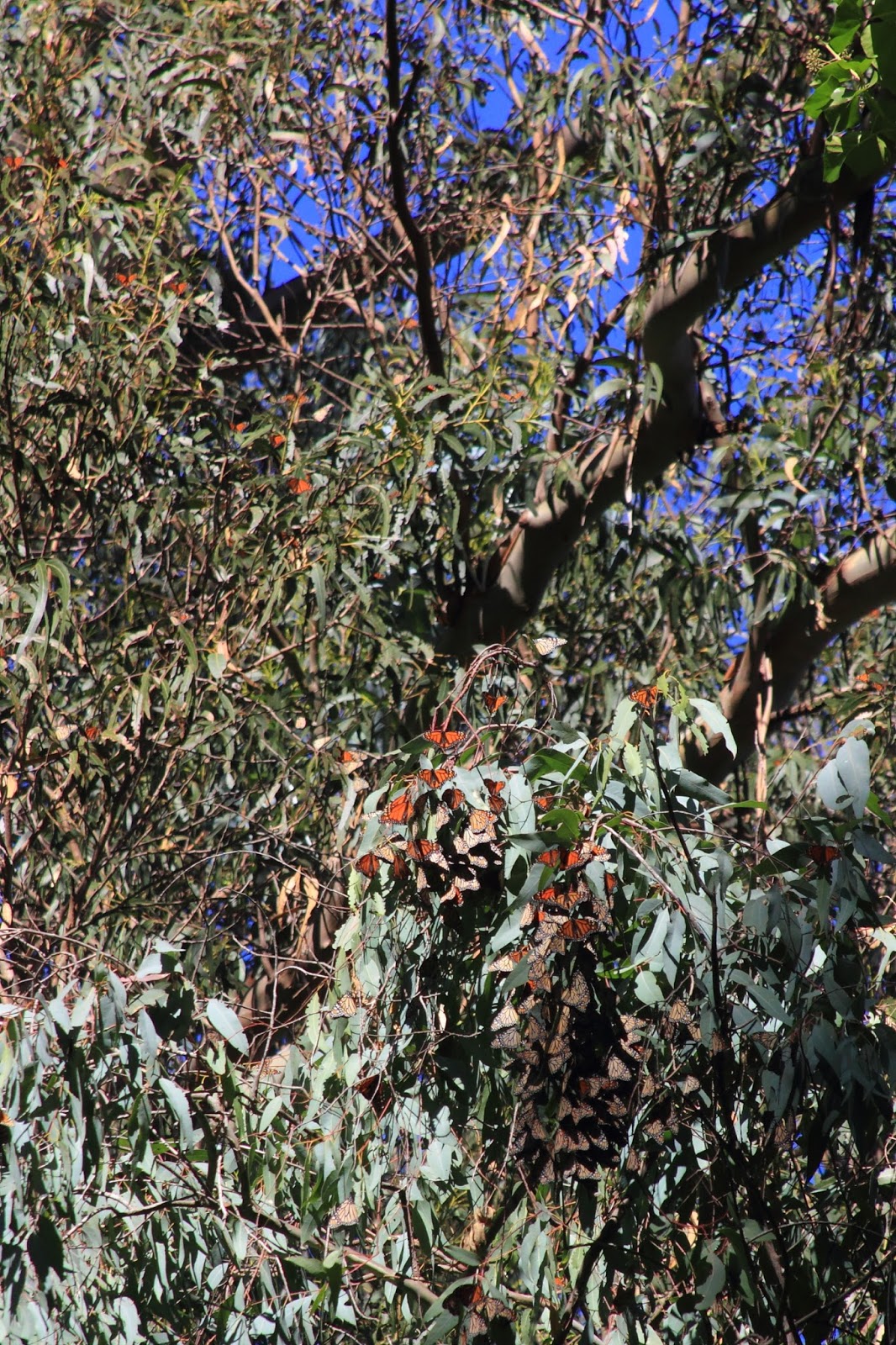 |
| These guys will burst into flight today, after three days of rain. |
The center of the low pressure has finally moved ashore and south of us. Some wrap around will send rain and snow to the interior. San Diego is getting a good rain right now. We will see intermittent showers in the morning, and will trend drier during the day. The air mass remains moist, and we could see showers pop up, even into the evening and night. Still, chances for that steadily drop through the day. Showers most likely this morning. Today will warm through the mid 50s. Some sun may break out. Friday morning will be the chilliest this week, especially if the sky clears. Low 40s, or cooler if there are stars. Tomorrow looks like a fine day to get out and explore a little. It should be dry in the morning. Waterfalls are flowing. The surf will still be pumping, but with easterly winds, should clean up nicely. Get it while it lasts, as the next storm in the train arrives late in the day and into the evening on Friday.
It will not pack a tremendous amount of rain with it. We are expecting about a half inch in town, and a bit more in the hills. A few inches of snow in the Sierra. Still, it is all adding up slowly. Rain should dissipate by mid day Saturday. Other than that, we are looking at a fair weekend ahead with dome decent (as compared to yesterday at least) surf conditions. And for those of you pining to get to the snow, this weekend should be decent, with a fresh few feet since the holiday hordes descended on Tahoe.
Tuesday, January 5, 2016
That was some water.
Approaching a two inch storm total here on the west side of Santa Cruz. Almost looks like I got more than that in my yard, but not in an actual gauge. My son and I decided we needed to get one soon. Paradise Park got just shy of two inches since midnight. Ben Lomond is reporting two and a half. The west side gauge I typically check is a bit east of here, and not on as much of a slope. It has recorded 1.48" since midnight and .49" from yesterday. A look at the sky, and at the radar, suggest more will come through in just a bit. The radar also suggests that points south, especially LA, are getting hammered right now. Bring it on. Wet us down. Our walls and drainage did their job this morning. That feels good. First real test is some time. But there is much more to come.
It looks like we will have more rain today. Perhaps another quarter inch by midnight. But over all, it will be slowing down locally, as the core moves south and east. Just what the southern end of the Sierra needs right now. Overnight will be our calmest weather. More winds move in through the early morning, with rain coming quick on its heels Wednesday. This storm looks like it will focus more inland, but we could be looking at another inch plus tomorrow. A half inch coming on Thursday. Highs remain in the 50s. Lows drop into the 40s.
EDIT: Since I wrote this earlier, some more rain fell. 1.51" More bands out the back. Enjoy.
Monday, January 4, 2016
A good overnight rain.
The best rains come over night and are gone by morning. It will not be quite like that with this storm, but not too far off. But first, Monday had a mildly wet morning with about two tenths of precipitation in town, falling mostly before 10AM. Felton was a good bit wetter tallying six tenths, and Boulder Creek got even more pushing three fourths of an inch. Nothing super exciting, but certainly a nice start to a wet week. Tonight we will see more rain filling in. We have already had a few showers since night fall in the area. A cold front will sweep in from the west after midnight, and will quickly drop some moderate totals. Basically, we will have some very heavy rain in the early morning hours, perhaps approaching an inch of by day break. Yup, and inch, mostly falling between 12AM and 6AM. So, expect some urban and small stream flooding. That is a big load, in a short period of time, for the earth to suck in. Especially after the light to moderate wetting it got today. Not really talking mudslide city here, but use caution when approaching those areas you know to typically flood.
Rain lightens considerably in the morning hours. It would not be crazy to see some cracks of blue in the afternoon. Cracks. Showery weather basically persists through Tuesday. It won't get too cold tonight, staying in the 50s. It won't get too warm tomorrow, staying in the 50s. Another round of rain expected to fill in early Wednesday. Lingering into Thursday. Then perhaps, kind of sort of a break by Friday. Actually, Friday looks like the best day for solar radiation this week.
Arriving shortly after the burst of rainfall tomorrow morning will be the arrival of a large, long period swell. This is not an off the hook, go grab your board type of thing, as local conditions will be brutal with gusty south westerly winds that will fill in tonight with the storm. Winds shift more south easterly during the day, but by then the damage will be done with the discordant south wind swell crossing up the building northwest event. Still, it will be fun to watch from a safe distance, as the fifteen foot at twenty second swell will be pushing waves into the twenty foot range. Could be fun victory at sea to watch. And maybe we will get lucky enough to see some select spots break well.
Rain just started to fall in the last ten minutes. Sounds consistent.
Sunday, January 3, 2016
Foiled.
I fell in line, and found myself foiled. Read my post from two days ago. It more accurately portrays today. Stiff SE wind, but not enough moisture tracking over head yet to bring rain. Instead it is a gorgeous winter day out there. Hoping to soon find myself tracking my son in Lighthouse Field. School starts up again tomorrow. Still look for rain filling in this afternoon. Watch the sky. You should get out there and enjoy it while it is here.
Saturday, January 2, 2016
Game On 2016.
2016 is about to bring it. Look at that sky. This storm is getting close and will soon over ride the area. The storm is still expected to break apart as it hits the displacing high pressure, but a more westerly track is looking to bring rain to our area on Sunday. GFS has come in line today. Confidence high for a wet day on Sunday. We could even see rain filling in before day break. This first round is on the lighter side, but just off shore decent totals are expected. That could mean an inch or more in the local mountains. It looks like the most continuous, and heaviest showers will occur in the afternoon and into the evening on Sunday. It will remain cool. My fantasy of 60F temps is being crushed as warm air never really gets a chance to fill in ahead of this thing. And even though it is under cutting the Rex Block, it is coming in fairly cold. Evenings are going to warm up a bit, into the low 40s after tonight. As for the rain, it should subside earlier in the day on Monday. We could still she showery weather, but it is likely to break up a bit into the afternoon hours. Don't worry though, as another system is going to arrive on Tuesday morning.
The storm on Tuesday looks like it will arrive early, and bring a bit more water. And a bit cooler temperatures. Daytime highs still in the upper 50s and night time lows still in the low 40s. Right now, there is a third wave forecast, which is the cold core of the Tuesday storm, coming ashore during the day on Wednesday. This could be a very cold and wet system. As it looks right now, the temperature will drop through the day, and precipitation continues into Thursday. This could bring some snow to the higher coastal peaks to our south. And with over four inches of SWE predicted, one may be able find some snow to play in nearby. Get your sleds ready. More on that as we get closer.
As it looks today, things should be clearing out on Friday, leaving behind a very crisp, and clear Saturday morning. We could be lucky enough to be enjoying snow capped hills across the bay. For those looking to get in the water the next week, expect a lot of changing wind conditions. You may be able to find the right place and time to get in, but the off shore high pressure flow is going on hold as of today. The snow, on the other hand, will be going off the hook. Ten inches by Monday, and a few feet by Friday. And it looks like each wave is colder than the prior, setting up a perfect snow pack.
Prepare for rain to arrive over night, but don't be surprised if it arrives later in the day tomorrow. Or before night fall tonight. Expect few breaks in rain this week. Be stoked if you get a full afternoon of sun. Someone in the water today said that it felt wintery. Yes it does. It does indeed.
 |
| Desolation sunrise. Those peaks are looking decently covered for the first time in years. Approach with caution. |
The storm on Tuesday looks like it will arrive early, and bring a bit more water. And a bit cooler temperatures. Daytime highs still in the upper 50s and night time lows still in the low 40s. Right now, there is a third wave forecast, which is the cold core of the Tuesday storm, coming ashore during the day on Wednesday. This could be a very cold and wet system. As it looks right now, the temperature will drop through the day, and precipitation continues into Thursday. This could bring some snow to the higher coastal peaks to our south. And with over four inches of SWE predicted, one may be able find some snow to play in nearby. Get your sleds ready. More on that as we get closer.
As it looks today, things should be clearing out on Friday, leaving behind a very crisp, and clear Saturday morning. We could be lucky enough to be enjoying snow capped hills across the bay. For those looking to get in the water the next week, expect a lot of changing wind conditions. You may be able to find the right place and time to get in, but the off shore high pressure flow is going on hold as of today. The snow, on the other hand, will be going off the hook. Ten inches by Monday, and a few feet by Friday. And it looks like each wave is colder than the prior, setting up a perfect snow pack.
Prepare for rain to arrive over night, but don't be surprised if it arrives later in the day tomorrow. Or before night fall tonight. Expect few breaks in rain this week. Be stoked if you get a full afternoon of sun. Someone in the water today said that it felt wintery. Yes it does. It does indeed.
Friday, January 1, 2016
And the year begins...
Almost felt like we would get some rain this afternoon. I know that it did rain on Wednesday over by Montebello, Mt Eden and Ridge. Or, so I was told. Saturday will be a cold one again. It was weird this morning. Temps had dropped to the low 30s by 4AM, but began to rise to near 40F around 6:30, only to drop back into the low 30s again by 7:30, slowly rising to 40F around 10AM. It was chilly out there. It never quite hit 53F today on the west side. Cold. More of the same tomorrow. The cloud cover does not help much during the day, but may keep low temps a few degrees warmer tomorrow morning. By tomorrow night we are seeing a chance of rain. NOAA is calling for 60% chance by Sunday, but looking at the models, I am not sure that I see that. What they might be referring to is wrap around precipitation ahead of the main cold front which should sweep through later in the day. Rain looks likely in the evening on Sunday, into Monday morning. It should be fairly light, except in coastal hills. This cold front could get a reinforcing wave of moisture later Monday morning. It will all depend on the track of the system as it breaks apart approaching the current high pressure. Areas south look likely to get more precipitation, as the low finally moved inland to our south. Wow.
So maybe not much of a rain maker. But round two arrive Tuesday night, with rain looking likely into Wednesday. Round three arrives sometime around Thursday. We are looking at several inches of rain next week, with some periods of heavy rain. Rain is in the forecast at least Sunday through Thursday. Perhaps longer. We will see three, four or even up to six inches of rain here along the coast by next Friday afternoon. Yes that is a lot. Get prepared. Waken from your holiday and egg nog induced slumber. Find that rain gear again. El Nino is coming by to pay us a visit.
Inclement weather could continue week 2 and into mid month. Time will tell. It will be worth getting organized tomorrow. I planted some lettuce, pea and carrot seeds today. I'll try to get my garlic in tomorrow. After that the ground is going to get wet and will be not worth working. Details coming as these systems approach. For now, I'd expect next Wednesday to be a hum dinger.
Subscribe to:
Posts (Atom)