This time of year is always interesting. Some days are hot, others warm, some cool and a few cold. Around this time last year we were at the beginning of a heat wave. In early May, Santa Cruz was experiencing mid 80s. Just like last weekend. One day it was hot, and then, just a few short days later everything changes. Clouds, cool breezes and some rain were the name of the story. In fact, a fair amount of rain. April is finishing out the way May started last year. The difference being, that after this little bought of wet weather, it looks like we will be going into a dry spell. It may even be the dry spell that marks the start of summer around here. Or, we could see more storms come out of the north. Time will tell.
This little system has finally moved into the area. And it is well positioned. Significant rain is falling to our north, as well as to our south. With some luck, we will only see light rain here in Santa Cruz, thanks in part to our south facing location, as well as to a split up storm. Really, two storms. One impacting the southern part of the state and one up on the OR border. Rain will be heavier over the coastal mountains and on the Sierra west slope. Showers will be the name of the game Thursday morning. And they still say a cold front is to come through, but it sure felt like that warm air got pumped in front of it today. Toasty, when the sun shone.
In short, the forecast has not changed. Sun by Friday and a nice weekend ahead. Maybe 70 on Sunday, and then a bit of cooling next week.
Wednesday, April 25, 2012
Tuesday, April 24, 2012
Toasted. Rain is a coming.
 |
| Palm Springs, California. Sitting at the pool at the Movie Colony Hotel. |
Showers on Wednesday and low 60s. Cold front moves through overnight and Thursday morning will start off in the mid 40s and top off around 60F. Showers continue. Again, that morning commute could be a doozy. Friday will still see a clearing and warm up. Back up into the upper 60s. The weekend is still on track for high 60s and plenty of sunshine. Next week looks like a continuation of this coming weekend.
Monday, April 23, 2012
Right on track.
Maybe it felt a little ahead of schedule yesterday when that cool damp marine layer decided to roll in and stick around through the entire day. Sure did not feel like it was int he mid to high 60s. In fact, it felt like it maybe just pushed up into the 60s but for a brief period. More of that continues today, as a decent sized, but weak low pressures slowly spins off the coast. This one is just a bit too close to pump in the hot dry air from the desert Southwest. Instead, we are are seeing moisture wrapping in from the south, being pulled off the Pacific and rammed into the coastal hills. You know what that means: Fog and cool air mass. And it looks to stick around for a few days. High of 50 in Santa Cruz today and a bit warmer on Tuesday.
By Wednesday, the storm to our west further weakens, and a second system gains strength in the Gulf of Alaska. As this storm builds and pushes south east, it will begin to absorb the souther system, and a push a wave of moisture over us, coming from the west. While today and tomorrow may see some fog drizzle (and thunderstorms in the interior and Sierra), we arn't expecting much rain. Not really even a steady shower. That changes by Wednesday evening, when showers and rain should begin to cross the entire Central Coast. Cooler air again moves through the area as cold front moves through overnight Wednesday. Rain continues through the morning hours Thursday. A reminder for the commuters: Give yourself extra time. As spring weather hits our zone, many drivers again forget how to drive in the rain. It must be in preparation for summer madness. Give space and be safe.
Thursday will be crisp in the morning, and cool throughout the day, maybe getting to 60F. We could see clearing by afternoon, and the sun will warm things up quickly. Could be a good afternoon to watch a sunset. May be the last storm clearing for the season. Up in the Sierra it will snow above 7500 feet on Wednesday. Maybe half a foot along the crest. Snow doubles on Thursday, with snow levels lowering to 6500. Overnight Thursday will get cold (for late April), with freezing temperatures dipping below 5000 feet. Santa Cruz will dip down into the low 40s, so put on a sweatshirt for Friday morning strolls. Which should be a nice morning, with increasing sun and high temperatures reaching back into the mid 60s by afternoon. And things just improve from there, with high 60s forecast, and maybe a chance of hitting 70F for Sunday. Like last Saturday? No way, but if that is what you are looking for, you best move else where. Still, plenty nice. And sunny.
So. M/T=Fog and Cool. W=Showers Late. Th=Rain, then clearing. F-S=The Goods. Enjoy.
 |
| Maybe this will warm you up. Desert wind field just west of Palm Springs, California. |
By Wednesday, the storm to our west further weakens, and a second system gains strength in the Gulf of Alaska. As this storm builds and pushes south east, it will begin to absorb the souther system, and a push a wave of moisture over us, coming from the west. While today and tomorrow may see some fog drizzle (and thunderstorms in the interior and Sierra), we arn't expecting much rain. Not really even a steady shower. That changes by Wednesday evening, when showers and rain should begin to cross the entire Central Coast. Cooler air again moves through the area as cold front moves through overnight Wednesday. Rain continues through the morning hours Thursday. A reminder for the commuters: Give yourself extra time. As spring weather hits our zone, many drivers again forget how to drive in the rain. It must be in preparation for summer madness. Give space and be safe.
 |
| Or this could help. Early evening on the links. 7PM and 95F. Palm Desert, California. |
Thursday will be crisp in the morning, and cool throughout the day, maybe getting to 60F. We could see clearing by afternoon, and the sun will warm things up quickly. Could be a good afternoon to watch a sunset. May be the last storm clearing for the season. Up in the Sierra it will snow above 7500 feet on Wednesday. Maybe half a foot along the crest. Snow doubles on Thursday, with snow levels lowering to 6500. Overnight Thursday will get cold (for late April), with freezing temperatures dipping below 5000 feet. Santa Cruz will dip down into the low 40s, so put on a sweatshirt for Friday morning strolls. Which should be a nice morning, with increasing sun and high temperatures reaching back into the mid 60s by afternoon. And things just improve from there, with high 60s forecast, and maybe a chance of hitting 70F for Sunday. Like last Saturday? No way, but if that is what you are looking for, you best move else where. Still, plenty nice. And sunny.
So. M/T=Fog and Cool. W=Showers Late. Th=Rain, then clearing. F-S=The Goods. Enjoy.
Saturday, April 21, 2012
Goodbye, fine, fine weather.
Just a quick update this evening to say good bye to the fine weather we had over the past few days. I'm not talking about the 100 degree heat my family experienced in the desert, but the low 80s here in Santa Cruz. When we got home this evening, the house was hot, and it felt more like summer in New England than the Central Coast. It was great. But it is headed on out. After a warm evening tonight, we will see a much cooler day on Sunday. Looking at high 60s. Almost 15 degrees cooler than today.
Follow that with some fog to start off the week and it will be feeling like summer around here. It may even get thick enough for some drizzle to form. Over night lows will slip back into the mid to high 40s and daytime highs will hang at just about 60F for Monday and a bit warmer toward the middle of the week. Just in time for some rain. Yup. Showers are likely to return Wednesday afternoon and into Thursday. High pressure looks to move back in Friday and for the weekend. More details and updates soon. Just need to unpack and return to normal life.
 |
| Rime formations at 10,000 feet near San Jacinto Mountain above Palm Springs, California. It was a beautiful day. |
Follow that with some fog to start off the week and it will be feeling like summer around here. It may even get thick enough for some drizzle to form. Over night lows will slip back into the mid to high 40s and daytime highs will hang at just about 60F for Monday and a bit warmer toward the middle of the week. Just in time for some rain. Yup. Showers are likely to return Wednesday afternoon and into Thursday. High pressure looks to move back in Friday and for the weekend. More details and updates soon. Just need to unpack and return to normal life.
Tuesday, April 17, 2012
Hello Heat.
There is some chatter out there about how winter is not over, and later this month, or even the next, we could see a return of a cold and wet pattern. But for now, it is best to focus on the reality on the ground. It is warm out there. Maybe not quite as warm as I thought it would be when I looked a week ago. The last of the cold was pushed out of the area on Saturday. As we drove south, we noticed cool air and increasing clouds, as we caught back up to the storm en route to Palm Desert. It was in the 50s in the foot hills of the San Bernardino and snow was falling in the higher peaks. Made for an interesting ski day atop Mt. San Jacinto 10,00 feet above the desert floor. More on that later.
Sunday, things began to warm up, but it has been a slow process. But don't fret, as we could break 80F by Friday in Santa Cruz. Lucky for us, we will still be in the desert. Can you say "hotness"? Even our usual cool nights will change, with our lows Friday and Saturday looking like last week's high temps. It could even stay up above 60F on friday night. Break out the t-shirts and shorts folks. And get on it early, as this deal won't last. As early as Sunday, things begin to cool off, and by next week at this time, we will be back down into the low to mid 60s. And about that return to winter, we could see some showers again before the end of the month. Stay tuned.
For now, it is nice. Warm today and warmer tomorrow. Some clouds out there keep it from getting too warm, but lets say 65 today, 70 tomorrow, low 70s on Thursday and low 80s for Friday and Saturday. Back down to about 70 for Sunday and mid 60s to start next week. You may want to think about getting some gardening done.
 |
| Palm Springs and the I-10 corridor, as seen from near Mt. Marion at 10,000 feet. |
Sunday, things began to warm up, but it has been a slow process. But don't fret, as we could break 80F by Friday in Santa Cruz. Lucky for us, we will still be in the desert. Can you say "hotness"? Even our usual cool nights will change, with our lows Friday and Saturday looking like last week's high temps. It could even stay up above 60F on friday night. Break out the t-shirts and shorts folks. And get on it early, as this deal won't last. As early as Sunday, things begin to cool off, and by next week at this time, we will be back down into the low to mid 60s. And about that return to winter, we could see some showers again before the end of the month. Stay tuned.
For now, it is nice. Warm today and warmer tomorrow. Some clouds out there keep it from getting too warm, but lets say 65 today, 70 tomorrow, low 70s on Thursday and low 80s for Friday and Saturday. Back down to about 70 for Sunday and mid 60s to start next week. You may want to think about getting some gardening done.
Wednesday, April 11, 2012
Bit and pieces.
A good few bits came through yesterday with a solid piece earlier this morning. As of midday, the sun is in charge, or at least trying to claim the title. The heavy rain of earlier has abated, and a few breaks exist in the cloud cover. When everything lines up correctly, it lights up pretty nicely outside. Could be a good afternoon for photography, with diffused light and rain drops on flower petals and all. But your window is slim, so get on it if you can. Best bet if for a lunch break jog, but after work hours should be good enough for most Bay Area peeps. Up north, they could begin to see the start of the next stage of this thing.
Rain still looks likely tomorrow. In fact, it looks to be pretty heavy and of a good duration. We are looking at over an inch of rain in the area over the next few days. The coastal mountains will get hit the hardest. Well, unless you consider the Sierra where the bullseye calls for over 3 1/2 inches of water. And with the seasonally cold temperatures expected, that is well over 30 inches. We could be looking almost four feet along the crest. Sure, that is a big number, and a more conservative guy might not talk so big, but sometimes you just get a feeling about something trending in a certain way. The powder day looks like Friday, with storm riding on Thursday. Don't worry weekend warrior, as cold air and showers should continue through Friday afternoon, making Saturday morning looking pretty nice. With a little bit of luck, you could be looking at free refills to start off the day. But get on it early as that post Easter sun and warm air temperatures are going to bake into into mank by afternoon. Try to stay in the shade.
For those of you who don't care about April powder, Friday should clear up by afternoon along the coast. This storm will push another sizable swell right to our door steps. It will take a day or so for things to clean up in town. The open coast won't be so lucky, as the typical spring NW gradient will build strong behind the storm. Lucky you, kite boarders. And for those who want nothing to do with H20, Saturday will shape up nicely. We move back into the 60s, with a slight chance for 70F some time between Sunday and mid next week. We will move past this storm and into a warming period. Might be the last big system of the winter.
 |
| Moss Landing Power Plant on a crisp clear day on Monterey Bay. |
Rain still looks likely tomorrow. In fact, it looks to be pretty heavy and of a good duration. We are looking at over an inch of rain in the area over the next few days. The coastal mountains will get hit the hardest. Well, unless you consider the Sierra where the bullseye calls for over 3 1/2 inches of water. And with the seasonally cold temperatures expected, that is well over 30 inches. We could be looking almost four feet along the crest. Sure, that is a big number, and a more conservative guy might not talk so big, but sometimes you just get a feeling about something trending in a certain way. The powder day looks like Friday, with storm riding on Thursday. Don't worry weekend warrior, as cold air and showers should continue through Friday afternoon, making Saturday morning looking pretty nice. With a little bit of luck, you could be looking at free refills to start off the day. But get on it early as that post Easter sun and warm air temperatures are going to bake into into mank by afternoon. Try to stay in the shade.
For those of you who don't care about April powder, Friday should clear up by afternoon along the coast. This storm will push another sizable swell right to our door steps. It will take a day or so for things to clean up in town. The open coast won't be so lucky, as the typical spring NW gradient will build strong behind the storm. Lucky you, kite boarders. And for those who want nothing to do with H20, Saturday will shape up nicely. We move back into the 60s, with a slight chance for 70F some time between Sunday and mid next week. We will move past this storm and into a warming period. Might be the last big system of the winter.
Monday, April 9, 2012
The last hoorah.
Well, kind of. But first, what a weekend! Up in the Sierra it was prime spring skiing. Cold nights, warm days, a clear sky and a slight breeze kept the corn in perfect condition. The upper elevations were prime with some hidden powder stashes from the storms of last week. I even got out for two runs with the little guy. He was the youngest schusser on the hill, without a doubt. And he loved it. What a fantastic weekend to be out on the snow. And today should be just as nice.
In fact, down here, ocean side, we are looking at a pretty fine day. Santa Cruz will struggle to hit 70F, but in our sunny and protected zones (read West Side) it will get pretty darn close. And with that April sun getting higher in the sky, it will be toasty when it is shinning down upon you. If you want to be sure to score heat, head just a bit inland to Scotts Valley, or over the hill to the Saratoga - Los Gatos zone. Yup, it will be 70 plus in them parts. The Central Valley will be even warmer. It was 76F yesterday at about 4PM in Clements and near Stockton. Ah, Spring has sprung. But don't expect that to continue for long.
Rain by Tuesday. And much cooler air. The storm that has sat off shore, just to our west, for the last few days (and pumping in that warm air) will move in later tonight. We should awake to showers on Tuesday and high temperatures about 10 degrees cooler than today. It will feel pretty wintery for sure. And it is going to stick around for a while. The rest of the work week looks wet. As we look at the week more closely, we have pretty good chances for showers through the day on Tuesday. It does look like this first system is fairly week and dispersed, so expect sporadic showery weather. Don't get me wrong, the precipitation will be moderate, and not light. It just won't likely be a solid rain spell. More off and on. A few inches of snow for the Sierra.
Wednesday looks cooler, as in mid 50s. At least the rain will be lighter. Lets call it light showers. Off and on through the day, lightest late in the day as we see a brief break between storms. The real water maker shows up late morning on Thursday and sticks around over night. Cold temps continue. But this thing will be moving through swiftly. Look for a foot and half of snow in the mountains. Freezing levels down below 5000 feet in the strongest squalls. Things should start to break up on Friday, but plan for continue cold and showery weather. You will need to wait for the weekend for some real sun. But don't expect too much of a warm up until the following week. Say around 62F for the weekend highs.
So. Sun and warmth continue today. Moderate showers and cooler Tuesday. Cold and light showers for Wednesday. Rain and cold on Thursday. Friday showers and cold. Clearing late. Sun and cool for the coming weekend. Chance of warming trend the following week.
In fact, down here, ocean side, we are looking at a pretty fine day. Santa Cruz will struggle to hit 70F, but in our sunny and protected zones (read West Side) it will get pretty darn close. And with that April sun getting higher in the sky, it will be toasty when it is shinning down upon you. If you want to be sure to score heat, head just a bit inland to Scotts Valley, or over the hill to the Saratoga - Los Gatos zone. Yup, it will be 70 plus in them parts. The Central Valley will be even warmer. It was 76F yesterday at about 4PM in Clements and near Stockton. Ah, Spring has sprung. But don't expect that to continue for long.
 |
| Clouds clear after a week of snowy weather at Kirkwood. After a brief period of warmth, snow returns this week. |
Rain by Tuesday. And much cooler air. The storm that has sat off shore, just to our west, for the last few days (and pumping in that warm air) will move in later tonight. We should awake to showers on Tuesday and high temperatures about 10 degrees cooler than today. It will feel pretty wintery for sure. And it is going to stick around for a while. The rest of the work week looks wet. As we look at the week more closely, we have pretty good chances for showers through the day on Tuesday. It does look like this first system is fairly week and dispersed, so expect sporadic showery weather. Don't get me wrong, the precipitation will be moderate, and not light. It just won't likely be a solid rain spell. More off and on. A few inches of snow for the Sierra.
Wednesday looks cooler, as in mid 50s. At least the rain will be lighter. Lets call it light showers. Off and on through the day, lightest late in the day as we see a brief break between storms. The real water maker shows up late morning on Thursday and sticks around over night. Cold temps continue. But this thing will be moving through swiftly. Look for a foot and half of snow in the mountains. Freezing levels down below 5000 feet in the strongest squalls. Things should start to break up on Friday, but plan for continue cold and showery weather. You will need to wait for the weekend for some real sun. But don't expect too much of a warm up until the following week. Say around 62F for the weekend highs.
So. Sun and warmth continue today. Moderate showers and cooler Tuesday. Cold and light showers for Wednesday. Rain and cold on Thursday. Friday showers and cold. Clearing late. Sun and cool for the coming weekend. Chance of warming trend the following week.
Friday, April 6, 2012
Warming Trend
Getting ready for a few days of fun in the sun. After a cold, breezy and very spring like Thursday, things will start to turn the corner today. Topping out at 60F is not in the forecast for the weekend. Hard to believe it will be warm today with the early morning low 30s here in Santa Cruz and below freezing temps in Scotts Valley. Brrrr. But as we start to see a medium low pressure system drop out of the Gulf of Alaska, set up off shore of us and grow in size, the heat pump is getting turned on.
Low 60s today. High 60s for the weekend. Pushing toward 70F for Monday. But this will of course, all come at a cost. Remember the low pressure system sitting and growing off the coast to our west. That thing that is pumping warm air from our south and giving us some superb spring days ahead. Well, sooner or later, it needs some where to go. And in general, at our latitude, things tend to move toward the east. And this one is a slow mover. Looks like we could even see a small squall move through as early as Sunday evening. Doubtful though. And it won't ruin our coming Monday (which is looking prett sick). But come Tuesday and Wednesday we start seeing that thing edge closer, and maybe even swinging some bands through. And as that storms moves closer, the pump shuts down and cool air from the north will be upon us. 60F on Tuesday and cooler the rest of the week. By Thursday, chances for rain increase. We could see a wt 24-36 hours. Maybe an inch, with over a foot in the Sierra by Friday evening. Maybe another good weekend beyond that.
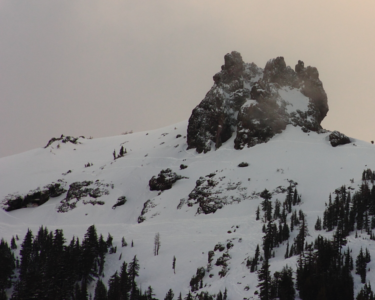 |
| Glove Rock looking majestic at the end of a spring powder day. |
Low 60s today. High 60s for the weekend. Pushing toward 70F for Monday. But this will of course, all come at a cost. Remember the low pressure system sitting and growing off the coast to our west. That thing that is pumping warm air from our south and giving us some superb spring days ahead. Well, sooner or later, it needs some where to go. And in general, at our latitude, things tend to move toward the east. And this one is a slow mover. Looks like we could even see a small squall move through as early as Sunday evening. Doubtful though. And it won't ruin our coming Monday (which is looking prett sick). But come Tuesday and Wednesday we start seeing that thing edge closer, and maybe even swinging some bands through. And as that storms moves closer, the pump shuts down and cool air from the north will be upon us. 60F on Tuesday and cooler the rest of the week. By Thursday, chances for rain increase. We could see a wt 24-36 hours. Maybe an inch, with over a foot in the Sierra by Friday evening. Maybe another good weekend beyond that.
Tuesday, April 3, 2012
Toasty. Then cooler. Then toasty. Might see a sprinkle.
 |
| Nom, nom. More to come soon at PowderHappy. Vailwood delivers. |
But, about the weather. Good stuff on tap. Tonight and tomorrow see the passage of a weak system. At least weak down here. The PNW continues to get pounded. Low air temps and a few more clouds seem likely. Highs will drop down into the high 50s and and just about there through Friday. We could see a few inches in the mountains, and a slight chance of light showers down here on the coast. This evening and tomorrow see the greatest chance of precipitation around here. More likely as you move north and east out of Monterey Bay. We will likely be stay dry here. Pay attention if you have any seedlings going. If they look good today, this could be a great week for them. If we don't get more rain tonight, just remember to monitor your soil and keep it moist. Because, by Saturday things begin to warm back up. Mid 60s to start the weekend, and by Monday we could seeing ow 70s, thanks to an off shore through that will be slow to move east. Expect to be seeing that thing move over us in another 8 days or so. I'll let you know how that develops as it develops.
For now, get ready for spring. This is the week. After a wet and cool March, we are about to get a week of the goods. Hell, if we had not had such a stormy March, we would probably not even notice this week after the winter of wonderful we had. But thank you storms! No we have snow and water and we re about to bake some corn. And the beach weather will be fine for those of you who prefer a bathing suit to a hard shell.
Subscribe to:
Posts (Atom)