Thursday, February 28, 2019

Crazy Pattern.

Well, we have more rain on the way.  I'll be not going out on a limb and suggesting we saw records for the month of February across much of the region.  Perhaps we can take a look at that tomorrow.  For now, get out there on Friday and enjoy the sun in the morning.  Should be a nice day.  Starts off cool, in the low 40s.  Might even break 60F across most of town.  Upper 50s to low 60s were recorded as highs on the west side today. Those higher readings are spot that were getting sunshine in the middle of the day. Just over a third inch of rain was recorded with this storm.  That is a lot less than the one plus inch I forecasted here, and way way less than what NOAA was calling for (up to three) or NPR (3-5" in town and 6-10" in the Santa Cruz Mountains).  Needless to say, this system way under performed.  And that worked out just fine with us.  More time for the earth to absorb, drain and heal.  Plenty of areas in the state are flooding right now.  The road into Pescardero would be an example.

Chocking on powder.  Kirkwood.  February 2019.


Light winds, moderate swell and sunshine in Friday make for some decent surf early. Late in the day the winds shift south, and by evening we could see the first drops of rain.  It looks like a decent night of rain, with a half inch likely overnight, with temps in the mid 40s..  Rain backs off quickly on Saturday morning, and it should be just sporadic showers by afternoon.  We see a slight chance of showers into Sunday, but I doubt we get more than a sprinkle after Saturday morning.  This system is fairly warm, and overnight lows move into the low 50s by Saturday night.  Afternoon highs in the upper 50s over the weekend.

Monday looks like another nice day, with some sunshine, and warming temps.  More storms are set to run through middle of next week. As of now it looks like a decent storm Tuesday night, with showers into Thursday. What is really interesting is we have a storm on the charts every few days over the next 16 days.  Yes, much of that is fantasy charts, but interesting none the less.  This aligns with a trough forecast along the west coast through the period, so yes, we could be in for a long run of moderately wet weather.

Vail just announced they will keep their Tahoe resorts open one extra week due to the deep snow pack.  Cool.  Squaw and Mammoth will be open until 4th of July, so there is really no contest there.  This will be a great year to enjoy some late spring skiing, as the snow pack in excellent shape, and over ten feet deep. That means there will be a lot of it around until the summer.  In my opinion, it is some of the best snow sliding of the year.  Just remember that sunblock.

Wednesday, February 27, 2019

We Didn't Need It.

Right?  Rain never really showed.  About a third of an inch last night, and I can see breaks in the clouds already this morning.  Main moisture stream is now well south of us, after spending much of yesterday and last night well north of us.  We just got a passing hit.  That is fine.  We are good on water right now, and perhaps this respite will help keep our mountains from liquidating.  I was out walking around Butano SP on Sunday and there are a ton of downed trees in the canyons.  But we are not out of the woods yet.  We still have several more weeks of winter and few more of the rainy season.  Chance of showers continues through tonight, with up to a half inch forecasted by NOAA.  Looking at radar, satellite and out my window, I'm thinking we end up with quite a bit less than that.  Still, carry an umbrella and/or raincoat around with you today.  High of 58F today.

When you learn your friends left the back door open for you.


Tonight stays warm, in the 50F, with light showers.  Thursday begins cloudy, with some afternoon sunshine and a high in the upper 50s.  A clear sky allows radiational cooling, and we see temps drop to about 40F by Friday morning, ahead of another rain system.  The rain for the coming weekend is now looking a little warmer and little lighter.  Saturday looks like the rain day, with clearer weather for Sunday into Monday.  We are looking at the chance for more rain as early as Tuesday.

Overnight lows warm a bit through the period into the mid 40s.  Daytime highs remain in the upper 50s.  We remain in a wet trend through the following weekend.  There is some suggestion that we could see some high pressure set up after that, but that has been the name of the game since New Years.  We will need to watch it as we get closer.  We are now looking at three weeks of kicking the sunshine can down the road.

Tuesday, February 26, 2019

Afternoon Deluge.

Pretty much on track so far.  No measurable rain just yet.  We did have a few moments of mistiness yesterday morning, and dark clouds, that made me think things moved in early.  Then, nothing.  Well, except some light rain last night in the Santa Cruz Mountains.  If you look on the radar you can see there is a ton of rain just to our north.  It will be just a few hours now before rain begins to fall locally.  Light at first, then heavy.  We should see about an inch and a half of rain fall from this mid afternoon through 3AM, then some lighter rain into the morning hours.  But not too light.  We could see up to another half inch by noon Wednesday, but I'm betting on juts a quarter.  After that, the rain subsides a bit, before another wave, weaker than the first, pushes through in the evening.  Temperatures remain fairly steady through the period.  Currently it is 53F, and we will likely stay in the 50s today, tonight and maybe Wednesday (we could hit 60F, whoop whoop).

Snow in the Santa Lucia.  This will all wash away tonight, with freezing levels between 5000 and 6000 feet.


Tahoe is already getting hit.  That cold smoke of the last three weeks is now under several inches to a foot of cement.  They are expecting 3-6 feet more snow this week.  Snow will back off on Thursday, and they will be digging out again, trying to prep for the weekend, and more snow.  Insane winter up there.  The resorts are all sitting at 400-500 inches of snow so far this season, with really no end in sight.  It is going to be such a great spring.  Too bad Vail thinks ski season should stop in early April, as Squaw will be running lifts into June this year and are aiming for July 4th.  So is Mammoth. Instead of chasing the snow through these storms, consider spending your money in April and May, when we are more likely to have fine weather and great tail gating in helot at the end of the day.

That second wave coming through Wednesday evening is nothing like the first.  More like sustained showers than a deluge.  We are looking at an additional few tenths of an inch by Thursday morning.  Then some clearing in the day time, with sunshine in the afternoon.  Look for a killer sunset. Winds shifts from the strong south westerlies we see all week, to a moderate north wind.  Might even get a chance for the surf to clean up a bit.  Friday looks fair, with clouds filling back in through the day. Daytime temps remain in the upper 50s, but with some cooler air and a clearer sky, night time lows drop back down to the low 40s.  Next system up stream arrives late Friday night.

This storm can be seen on the satellite spinning offshore.  It has a good amount of moisture with it, but its main plug is expected to be just to our north. Again.  Not far enough north to hit the drought areas hard, but far just a hair north to spare us.  As it sits now.  Looks like the rain will begin in the early morning hours Saturday and rain pretty heavy through the afternoon, before shifting east.  This one looks swift, so we may not see big accumulations from it.  About a half inch by Sunday mid day.

We could see another storm as early as next Tuesday night and lasting through the middle of next week.  And another next weekend, and another the following week.  Word on the street is we are now officially in weak El Nino, so there is that.

Sunday, February 24, 2019

Cranking Up.

Forecast models come to agreement that we are going to get walloped.  GFS is calling for five to seven inches of rain over the next week.  That is a lot, and everyone should prepare for some more flooding, downed trees and power lines, along with issues on the commute.  Wednesday morning looks like the roughest drive of the week, but things will be rough Tuesday through Thursday.  Here is the nitty gritty as I see it now.  Monday will be cloudy and cool in the morning, with some light rain likely by afternoon.  We are only looking at about a tenth of an inch by night fall, so not too much.  The temperature is likely to stay steady in the mid 50s in the evening, as rain becomes more likely. Southerly winds increase through the day, with gusts to about 30mph by dark, and to 45mph overnight.  There is an AR stream just to our north during this period, so it is hard to tell when it will begin to hit us directly.  Until it does, we will remain warmish, and less wet.  It looks like it will begin to take aim at us Tuesday.

Mike used up some frequent flyer miles to get this hang time.  Dog Leg, Kirkwood.


Temps remain in the 50s, rising to near 60F mid day.  Rainfall rates increase through the day. Possibly as light as showers at sunrise, but likely a moderate to heavy rainfall by afternoon.  Winds lighten during the day, but pick up overnight again.  Strong and southerly through the period.  We likely will see an inch from Monday sunset through Tuesday sunset.  An additional 1.5 inches by Wednesday sunset.  The heaviest rains are expected overnight on Tuesday.  Wednesday morning will be in the low 50s, as the rain subsided through the morning.  With luck, the Farmer's Market will not be too wet.  Temps rise into the low 60s.  Showers continue into the evening.

Thursday might give us some sun and some warmth.  Showers could persist though.  All in all, we are looking at two to four inches of rain in town during this period, with perhaps more than that in the local mountains.  We are moving into the record breaking territory for the month of February.  The CA Drought Monitor now has 67% of the state completely out of drought, with 29% Abnormally Dry.  These are areas in the north, and San Diego to Arizona, south of the Salton Sea, along with a credence around the southern rim of the Sierra.  That leaves 2.4% and 1.4%, along the northern border, in Moderate and Severe Drought.  We are moving in the right direction.

More wet weather for the weekend, and possibly next week.  It seems we are in the opposite pattern as the drought.  It keeps on looking like we will have a dry period ten days out, but as we get closer, things get wetter.

Saturday, February 23, 2019

And Keeps On Giving.

Cold weather through the middle of next week.  Storms likely stay north through then as well.  I did not post much last week as I was in the Sierra sampling the snowpack.  I can attest it is deep and has a great surface for schussing.  From what I hear, plenty of other people were out today sampling that same snow pack.  I prefer doing it during the week, and during the storms.  Kirkwood was a ghost town much of last week.  Wednesday was especially quiet, with a nice southwest flow, and fresh fluff falling.  One of those days that just gets better with every lift.  And it was cold.  In the teens.  Still is chilly, as it was down here.  We were in the upper 50s much of today, but with that cold breeze, it did feel a bit cooler.  Temps are in the upper 40s now and will drop to about 40F overnight.  Sunday should be chilly, in the upper 50s, with cloud cover developing through late morning.

Corey Lochan and Deadwood Peak, caked in cold snow.  We have water.  More is coming. 


Then things get interesting.  And here is where I back track just a bit.  See, there is a storm coming.  Perhaps even an Atmospheric River. When and where is not exactly certain.  But I'll walk you through the 18Z GFS.  Tomorrow the rain will be well to our north; enough so that we don't have any chance of it falling here.  By Monday, the stream of moisture coming off the Pacific will be in the northern portion of California.  We could see some light rain here late in the day, but at this point, that is not looking likely.  It will remain chilly, in the 50s, on Monday. Monday night and Tuesday, we continue to see the rain system move south, but we are still expected to be on the southern fringe. Maybe we are looking at a half inch of rain by Tuesday dusk.  Of course, this could increase with a sight southerly shift.  It will be raining hard just to our north.  An inch or two every twelve hours.  It will be a bit warmer Tuesday, as SW flow ushers in warmer air.

Tuesday night is when we get hit.  About an inch of rain over night, and almost as much on Wednesday.  It will be another heavy rainfall. While it will be over a week since the last rainfall, this one will add a lot of water to a still saturated ground.  Plan of some commuting delays Wednesday.  The air will continue to warm, and we will be in the low 60s. Things settle down over night, and by Thursday we will be in the wake of the storm.  It will be the warmest day of the week, in the ow 60s. It may also me one of the nicest, and just a short break before another system arrives for the weekend.  This one looks colder, but not as cold as the last three weeks.  Update  on that as we get closer.

For now, enjoy the fine weather this weekend and maybe early Monday.  Storm arrives by Tuesday, and rages into Wednesday morning.  A break Thursday and more rain possible for next weekend.

Tuesday, February 19, 2019

Winter is Cold.

Up in the Sierra there is 14 to 23 feet of new snow in the last two and half weeks.  It is currently cold, with highs in the 20s.  This is as good as it gets in Tahoe.  For those of you not enjoying the winter wonderland that is out there, think spring.  We will have mountains stacked with snow through June this year, even if it were to stop snowing now. But that is not quite going to happen.  The next few storms look really light with just a few inches, but continued cold through months end.

Santa Cruz is a bit warmer, with highs in the mid 50s and lows in the mid 40s.  Not much change in that this week. An inside slider tomorrow could bring light rain, but the storm is mostly east of Santa Cruz.  It will reenforce cod air, and there is an outside chance of snow in town Wednesday night.  Get up early to enjoy the outing on Thursday.  Sun returns for Friday, but another storm to our east brings cold winds and a slight chance of showers this coming weekend.

The following week currently looks sunny, with high pressure.  Still, we are seeing the suggestion of a storm under cutting the high and getting to us the middle of next week.  There is even a stronger suggestion that we could see storms return by the first weekend of March. So much for fair weather.  At least we are getting our water.  More to come.

Friday, February 15, 2019

Cooler and Calmer.

Winds are down from last night.  Temps are also down.  Mid 40s out there at 6:30 this evening.  The heaviest rain is behind us, but we did see a pretty strong squall this afternoon around 4PM.  Rains were heavy at times, but accumulation was less than the original forecast.  NOAA pulled way back on their forecast Wednesday afternoon, and form there it looked pretty accurate.  Almost a half inch fell today, and a little more than a half inch fell yesterday.  All in, we are looking at about 2.5 inches storm total so far.  We could see some more showers, and even a short squall.  A half inch by Monday, at most, and most of that tonight and Saturday night.  And then we get two days of mostly sunshine. Good news.  We need that sun now.  Water, not so much.

A third of the state is completely out of drought, and another 50% just Abnormally Dry.  Less than 10% is designated as Moderate, and about 1% Severe.  The northern boarder and San Diego are basically it.  As of reports released yesterday.  With the rain today and this weekend, we should see continued improvements.  Not to mention the systems expected for the middle of next week and maybe the following weekend. I promise, beyond that, we will see a high pressure.  I hope,  As much as I always say we need water, right now, we need to dry out.  Trees are falling across the highway, and crushing houses.  Mud slides are beginning to become a real concern, and that will last for weeks, even with no more rain.

Cold for the week ahead.  This morning was the warmest it will get.  Lows in the low 40s tonight, high on Saturday in the low 50s.  Lows dip into the upper, and then mid 30s.  Highs will climb to the mid 50s next week, and will especially feel warm on the sunny days.

Rain tonight, chance of showers Saturday.  Rain Saturday night, chance of showers Sunday.  Clearing Sunday night, sunny Monday and Tuesday.  Clouds on Wednesday, with a chance for more showers into Thursday.  More on that as we get closer.  Just want to note we are not out of the weeds yet.

Be careful out there folks as you drive over the mountain.  Or on the back roads. Or if you venture near the ocean.  A large long period swell arrive today.  Reading 18.5 feet at 17 seconds as of now. While a lot of that height is likely wind swell stacked on top, that is pretty hefty.  Breakers will sweep well up the rocks and cliffs at the coast.  Use plenty of caution.  And you are thinking of charging this weekend, please be careful.  It is going to take several days for the ocean to settle and calming make for good riding conditions.  If you can wait, Monday and Tuesday look much better, if a bit smaller.

Wednesday, February 13, 2019

Warm, Wet and Wild.

Mid 40s this morning on the west side.  That is balmy.  Almost two inches of rain since this started last night at 9PM.  It has been a steady pounding all night, and we are already seeing some urban flooding.  The roads are very wet.  Slow your roll and be cautious.  As of 7:30, the rain has subsided, but the winds are still raging out of the south.  38mph out at sea and 19mph at the Marine Lab.  Rain is expected to continue today and tonight, so this respite is short.  We still have a forecast of 1.75-2.5 inches of more rain by late Thursday.  That is a ton, on top of the two we have already seen (and blew away our forecast).  Expect doom downed trees and power line, especially in the mountains, by this evening.  We are in the midst of a Pineapple Express fighting an Arctic Low.  It will be quite the storm show for us to enjoy.

We remain mild for the next two days.  Not too warm endnote too cold.  In fact, the high today is expected to be around 57F, and the low tonight around 54F.  By Thursday evening a cold front should pass through, dropping the temperature several degrees.  Lows return to the mid 40s Thursday, low 40s for the weekend and upper 30s early next week.  Showers continue through Saturday or Sunday.  More on this later.  Got to get the kiddo off to school.  For now, wear a rain coat.


Edit & Update:  This morning I was looking at a Bonny Noon gauge when I said almost two inches.  Here on the west side we were about one inch of rain as of 7:30 this morning and now sitting at about 1.6 inches.  Looking at the radar, the main AR is still aimed at us, or even a touch north.  It will stay at about this trajectory through this evening and then move south.  We should continue to see some heavy rain over the next 24 hours, but are currently sitting in a shadow.  Hoping we are still in the shadow when I hit up the market this afternoon.

Tuesday, February 12, 2019

Cold Smoke

We went up to Kirkwood to enjoy the storm these past three days.  Wow.  Cold, dry, deep powder was the name of the game. Even our sled runs were deep.  The best dove under a tree branch and then banked a turn, all three feet below the snow surface. It felt like sledding down through a tunnel. Good times.  The mountain is skiing very good, and the snowpack is now at mid-high tide.  The small cliff bands are now just roll overs and the big stuff is starting to come into play.  If you have you heart set on Heart Chute, this may be the season.

Here in Santa Cruz, it is continued cold in the mornings.  Upper 30s at 6AM on the west side, but it was down in the ow 30s a few hours ago.  Tie Gulch in reading in the upper 20s.  It is cold out there.  Yesterday warmed into the mid 50s, and today we are expecting more of the same. Mild and sunny.  Good thing we got the last few days, as the rain returns tonight, and in earnest. Like up to a half inch by Wednesday morning, and that is just the start of it.  This storm is a little different than the last two.  First, it is the collision of two systems.  A Kona Low, generating an Atmospheric River, aimed just to our south, and a cold northern hemisphere low pressure moving south out of Canada. It will be the war of warm versus cold.

On Wednesday, that warm AR will be winning, driving right over us, giving us copious rain, and temperatures staying in the 50s overnight.  We are forecast to see almost two inches of rain here intern from 3AM Wednesday  to 3AM Thursday.  That is a good deal of rain for 24 hours, especially seeing we could have another quarter  inch in the six hours preceding the heavy rain, and a god deal in the day after.  This is a heavy rain event folks, and we will likely see some urban and creek flooding.  Remember, it was raining just a few days ago. And a few days before that.  And a few days before that.  The ground is still super saturated, and that leads to mud slides.  Please give your selves ample time on the Wednesday commute.  Both ways.

On Thursday, the the cold low pushes south, and the AR moves south with it.  Temperatures will drop with the cold front, and the rain will become much less heavy.  Daytime high will be in the mid 50s (down form that balmy upper 50s forecast for Wednesday), but night time lows will make a bigger dip.  First into he upper 40s, then lower 40s by the weekend. The cold low will provide much lower rain fall rates, but could continue moving rain bands over the region into the weekend.  Thursday we are expecting up to a quarter inch of rain, the showery and cool weather into the weekend.

Good news is that sunshine is on the horizon. As we move into President's week, we will be in a cool pattern, with storms moving out of the north, main to our east.  We might see some light precipitation from a passing system, but mostly expecting fair weather.  The following week, the trough is supposed to move further west, giving us a break in storms, and setting up a high pressure for the last week of the month.  It could become gorgeous out there.  And speaking of gorgeous, that sunrise going off right now is just that.

Friday, February 8, 2019

More Rain And Local Snow.

Yesterday was pretty damn nice.  Crisp, for the most part, but that sun sure felt warm after another morning with lows around 32F.  This morning is a touch warmer, as the next system is bringing in warmer air in front of it.  About 40F just before sunrise.  We wake to a mostly cloudy sky.  There was a short drizzle last night, but it looks like the rain will hold off for at least a few hours today.  GFS still suggesting rain will hold off until evening, but NOAA, which uses the GFS for their forecast, suggest rain before noon.  I think we could see some showery weather today, but the rain storm comes around sunset.  It could moderate to heavy at times this evening, and then returning to showers by sunrise Saturday.  Looking at about 3/4" of rain by then, and a low of around 42F, which puts the freezing level just above 3000 feet.

This weekend looks slightly wet.  Showers could persist through the entire weekend, as a second storm dives down from the north, just barely to our east.  That will increase precipitation rates Saturday night, into Sunday morning.  Showers back off Sunday afternoon, with a slight chance for light rain Sunday night.  Freezing levels are expected to drop back down to about 1200' on Sunday night, so another dusting of the local peaks is likely for viewing on Monday morning.

If you look at our mid endlong range forecast, it is pretty damn wet.  Chance of rain or showers every day for the next ten days.  The big news here is that a storm dropping from the north, bringing cold air, might interact with a subtropical, and warm moisture feed coming off the Pacific around the middle of next week.  The GFS the last few runs have suggested Armageddon.  It backed off from that a good deal with the 06z run today, but we could see a lot of rain middle to end of next week.  Check back here and other sources to stay prepared.  Travel in the local mountains could be quite treacherous at times. Getting to the Sierra could be seriously delayed.

Wednesday, February 6, 2019

Cold and Snowy.

Yup, here in Santa Cruz it is freezing.  Temps across town are in the low 30s.  King and Van Ness, along with many other locations are registering 32F.  Right out on West Cliff, and on the Wharf, resigns are 35F.  That is chilly folks.  Low 30s and upper 20s in the Santa Cruz Mountains.  And there is snow up there above 1500 feet.  If you did not so yesterday, get down to the water and have a look around the bay.  There are snow caped mountains all around us.  My Ununhum, at just under 3600 feet is caked with snow.  We never had a view of Junipero Serra in good light, but at almost 6000 feet must have gotten a good sparkling of snow on its top half.  It is game on for skiing with views of the Pacific, if you don't mind a bunch of bushwhacking.

Today will be mostly clear and crisp. A touch warmer than yesterday which barely climbed to 50F.  Looks like another cold night ahead of us.  Repeat on Thursday, and then on Friday, we see another cold storm moving in from the north.  This really feels like winter.  Snow levels will be a bit higher than the end of this last storm; more like Sunday night, at about 3000 feet.  That would mean some more snow for the higher peaks in our region.  As it looks now, we should see just clouds moving in Friday morning, with rain holding off until later in the afternoon.  This is not a big rain maker, maybe a quarter inch overnight.  Saturday also looks wet, as does the weekend.  Showers both days, with moderate rain expected to return Sunday evening.  About an inch total of rain through mid day Monday.  There is a lot of changing in the models from run to run, but it looks like we should see a break next week, for at least a few days, before more rain moves in.  This is turning out to be an excellent February for water and snow.  DeLaveaga is currently at 3.77 inches just 5 days into the month; nearly half as much that we received in all of the previous month.  And more is on the way.

In the Sierra, five to nine feet snow was recorded at the resorts.  They are digging out.  Much of that snow fell at very low temperatures and is super low density.  With the continued cold this week and weekend, we can expect for some of the best riding of the season.  Today should be gangbusters with resorts getting more terrain open.  It may take until tomorrow to get all the roads, passes and ski lifts in Tahoe open, up and running.  This was a massive storm up there.  With snow coming for the weekend, please be prepared if you plan to drive in the Sierra.  As it stands now, Sunday could be another stormy day, with pass closures by afternoon.  Plan accordingly.

And finally, surf has been cleaning up front he storms.  We have a bunch of wind swell out there, and a bit of ground swell.  While it might not actually get organized until later in the week, with more storms coming, there is a short window to get out there.  Town is looking fairly lined up this morning, but swamped with the higher tide.  Still, the view should be great out there, with snow capped peaks looking down on you.  Get out there and get some.

Monday, February 4, 2019

Last of the Big Waves

About a half inch fell overnight on the westside.  Almost another quarter inch since sunrise.  Rain has been steady for the last hour, but there is not a whole lot of solid rainfall west of us.  This might be the last of the heavy bands.  That doesn't mean we won't see another half inch before tomorrow.  But the sky is the brightest it has been in days.  So there is that.  Chilly out there today and it will remain so for the next week or so. Overnight lows will drop into the mid to upper 30s the next few nights.  Freezing level is about 3000 feet right now, and there is wet snow falling at Castle Rock State Park.  Could be a good day for a snowy hike tomorrow.  Should be in the low 50s on the coast and upper 30s at the summit.  Otherwise, not much of a change in forecast.

Freezing levels drop below 2000 feet overnight.  They may even get as low as 800 feet, which is just above Scotts Valley.  The roads could be very slick Tuesday morning, especially over the summit.  We could even see some road closures, but I'm not really expecting that.  The next few days will be chilly.  Sun comes out Tuesday and sticks around for a few days.  Next system upstream could arrive as early as Tuesday, and may put some more snow on the ground below 6000 feet.  It sure is winter.

Drought conditions have improved.  Almost a quarter of the state is completely out of drought and just a little over fifty percent is listed as Abnormally Dry.  That only leaves about 22% listed in Moderate Drought and less than 2% Severe Drought.  Three years since end of the period of really dry winters and we still have a ways to go.  Still, we have made more back than we have lost.  And these reports are from a week ago, so the last three and half inches here on the coast have not even been counted.  And there looks like we will get more later this week, especially in the north where conditions are driest.  So we are in pretty good shape.

Last of the Big Bands.

About a half inch fell overnight on the westside.  Almost another quarter inch since sunrise.  Rain has been steady for the last hour, but there is not a whole lot of solid rainfall west of us.  This might be the last of the heavy bands.  That doesn't mean we won't see another half inch before tomorrow.  But the sky is the brightest it has been in days.  So there is that.  Chilly out there today and it will remain so for the next week or so. Overnight lows will drop into the mid to upper 30s the next few nights.  Freezing level is about 3000 feet right now, and there is wet snow falling at Castle Rock State Park.  Could be a good day for a snowy hike tomorrow.  Should be in the low 50s on the coast and upper 30s at the summit.  Otherwise, not much of a change in forecast.

Freezing levels drop below 2000 feet overnight.  They may even get as low as 800 feet, which is just above Scotts Valley.  The roads could be very slick Tuesday morning, especially over the summit.  We could even see some road closures, but I'm not really expecting that.  The next few days will be chilly.  Sun comes out Tuesday and sticks around for a few days.  Next system upstream could arrive as early as Tuesday, and may put some more snow on the ground below 6000 feet.  It sure is winter.

Drought conditions have improved.  Almost a quarter of the state is completely out of drought and just a little over fifty percent is listed as Abnormally Dry.  That only leaves about 22% listed in Moderate Drought and less than 2% Severe Drought.  Three years since end of the period of really dry winters and we still have a ways to go.  Still, we have made more back than we have lost.  And these reports are from a week ago, so the last three and half inches here on the coast have not even been counted.  And there looks like we will get more later this week, especially in the north where conditions are driest.  So we are in pretty good shape.

Saturday, February 2, 2019

Big Change Since Last Night.

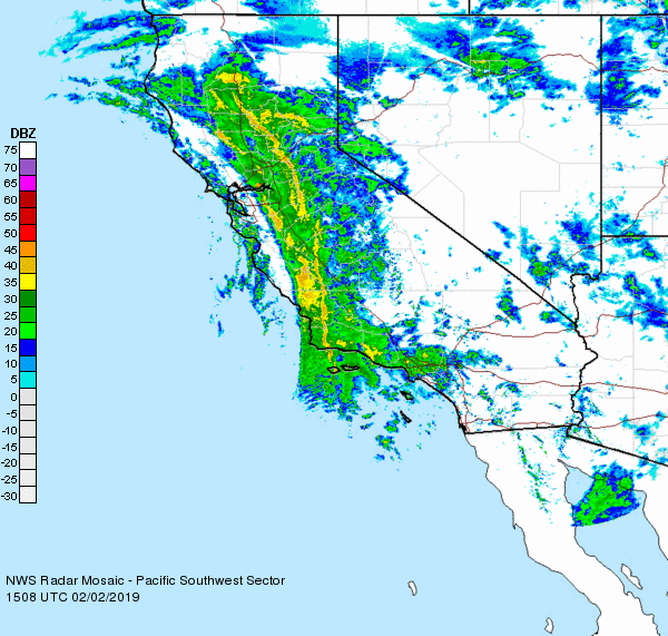
That storm pushed onshore a lot faster than expected.  That has both shifted when we get the heaviest rain and hit much we will get.  In short, the first, and strongest, band of rain has already moved to our east.  It is pretty impressive and currently effecting the Central Valley in an arc from Point Mendocino to Point Conception.  A secondary, and much milder, band is is setting up along our coast.

Impressive band of moisture arcing across the state.


This by no means is to suggest the rain is over for today, just that it will be much lighter than forecast.  With the storm moving through so quickly, a lot rain fell last night.  A little over an inch here on the westside and and inch and a half in the hills above town.  And while we had a break for a few hours just now that rain just started up again.  I'd expect bands of precipitation to move through until mid day, and maybe we get a little more showery weather by this afternoon.  That is good news for those of us who like to get out and hike in this weather. And my son's afternoon swim school class.

It is currently 50F out there and not expected to get much warmer than that over the next few days.  In fact, the big news is the colder air filtering in with each new wave of storms.  By Wednesday morning, we could be looking at morning temperatures in the mid to low 30s.  Freezing levels are expected to drop down to between 2000 and 1000 feet above sea level.  That would mean we would see snow on the top of Route 17.  And on the top of the mountains around the Bay.  Anyone want to hike for some turns or a snowball fight?  Tuesday and Wednesday are the days.

This storm is just now reaching the Sierra.  A few inches on the ground already, but a lot more to come in the next 24 hours.  And then, sort of a break Sunday morning to mid day, then colder air and lot more snow. Forecast models last night were calling for up to 6 feet at lake level with a to more at the peaks.  Like u to 10 feet, with localized amounts of 13 feet.  This is a Tahoe storm.

A grey sky and winds are the name of the game today.  Rain this morning, with showers by afternoon, and maybe a big enough break to get out for a hike.

Friday, February 1, 2019

Wet Start to February.

Pretty spot on with the rain starting at 4PM, with a chance of showers earlier.  We saw some light rain from 1:20 this afternoon until just before 2PM, but then a break until just about 4PM.  Only a few hundredths of an inch so far.  Winds are gusty from the south.  25mph on the Monterey Buoy and 34mph on the outer buoy.  That is strong.  13mph at the yacht harbor.  Rain is light right now, but the storm is just offshore and will pour onshore in the next few hours.  In fact, rain is falling on the Humboldt, Marin, San Mateo and Santa Barbara coastlines.  It looks like we will see some light rain and showers, develop into moderate to heavy rain around midnight.  The heaviest rain falls between just before sunrise into the early afternoon on Saturday.  By sunset Saturday it looks like we will see about an inch and a half of rain.  We should be expecting some minor creek and urban flooding tomorrow.

The ground is still very wet from the past week's rain.  The coastal bluffs are bogged out after all that water has finally run off the hills.  Adding more to the drainages is going to have a big impact.  There is not a lot of room in the soil for more water.  King street, around Van Ness and Laurel will likely have some deep water spots by afternoon.  The trails will have water running in them in the Pogonip. Luckily the next few waves of storms do not look quite as severe.  By evening this first storm will be mainly east of us, effect Sierra.  Big Sur could continue to see heavy rains.  About an additional half inch over night by Sunday morning.

Rain and south winds continue into Sunday.  The storm will be backing off Sunday morning, but ramping back up Sunday night.  We will likely see a decent break in the storm during the daytime hours, as it looks now.  Still, we could see a quarter inch or more of rain during the daylight hours.  From Sunday night through Monday afternoon, more rain.  Wind looks like it will be setting uo north westerly, but the storm won't be behind us.  Perhaps another inch plus of rain during this period.  The rain backs off again in the evening Monday, but showers sick around into Tuesday.  Wednesday even.  Another quarter inch or more.  Kind of feeling tough to count. GFS says four plus inches intern and five to seven in the Santa Cruz Mountains.  That is a lot.

With winds blowing tonight into Monday, and saturated grounds, it might be a good idea to check on the batteries in the flash lights.  And cozy down snacks are stocked in the pantry.  Could be a wet and wild weekend for sure, and you want to save up your energy for what is sure to be a crazy Monday morning commute.

Speaking of flooding, we are going to get another moderate long period swell filling tonight, along with strong southerly winds, heavy rain fall , and a very high tide for Saturday morning, expect to see some coastal flooding tomorrow morning.

If you are planning on driving up to Tahoe this weekend, be prepared for long car rides. Carry chains,  extra food, water and warm clothing to blankets.  You may find yourself stuck on Sunday. If you plan to get home to the Bay Area on Sunday, watch the storm and roads closely.  They will start hutting at some point and it will take a while for them to reopen.  I fully expect 80 to shut down due to accidents on Sunday, and we could see the Spur on 88 close down before then, shuttling everyone in Tahoe over 50.  It will be a cluster for sure.